This item has been sold, but you can get on the Waitlist to be notified if another example becomes available, or purchase a digital scan.
1857 Rogers and Johnston Map of the Nebraska Territory at its largest
TerritoryNebraska-rogers-1857$550.00

Title
Territory of Nebraska.
1857 (dated) 14 x 17.5 in (35.56 x 44.45 cm) 1 : 3450000
1857 (dated) 14 x 17.5 in (35.56 x 44.45 cm) 1 : 3450000
Description
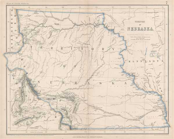
This is a rare 1857 Henry Darwin Rogers map of the ephemeral Nebraska Territory at its fullest, extending from Kansas to the Canadian border. Few maps illustrate Nebraska in this form, and most of those only as part of a larger map. The presently offered map is the only published commercial map to specifically focus on this early configuration of Nebraska territory. Cartographically the map is derived from a larger wall map also issued by Rogers and Johnston.
The territory of Nebraska was organized and incorporated on May 30, 1854. It was then a sprawling region occupying much of the American Midwest, extending from the Rocky Mountains and Washington, Oregon, and Utah to Minnesota and Iowa and from the 49th Parallel, or the border between Canada and the United States, to the Nebraska-Kansas border at the 40th Parallel, including part, or the entirety of, modern-day Montana, Wyoming, South Dakota, North Dakota, Nebraska, and Colorado.
When this map was issued, this vast territory was mostly unknown, the province of American Indian nations, with few towns or cities of note. Officially Nebraska territory lasted until 1867, when Nebraska became a state, but in fact, pieces of the territory began to be peeled off as early as 1861, when Colorado and Dakota Territory were formed. In 1863 Idaho Territory also peeled off.
Several towns and villages throughout the territory, although mostly along the rivers. Omaha City, which is now known simply as Omaha, Bellevue, Brownsville, Plattsmouth, Weeping Water, and Tekamah are all labeled along the Missouri River, while Grand Island, Fort Kearney, and Fort Laramie are labeled along the Platte River. Chimney Rock, Courthouse Rock, and Scott's Bluff, waypoints along the Oregon Trail, are also labeled. The proposed routes of the Pacific Railroad are also noted, illustrated here with purple lines. Numerous rivers and streams meander their way across the territory, including the Niobrara River, the Yellowstone River, the Republican River, and the Loup Fork. Mountain passes, peaks, lakes, buttes, and other physical features are labeled throughout.
This map was produced by Henry Darwin Rogers and engraved by Alexander Keith Johnston in 1857. It was published by John Murray in London and included in the Atlas of the United States.
CartographerS
Henry Darwin Rogers (August 1, 1808 - May 26, 1866) was one of the first professional geologists in the United States. Born in Philadelphia, Pennsylvania, Rogers was given his middle name in honor of Erasmus Darwin, who penned the poem 'The Botanic Garden', of which Roger's father was a great admirer. In 1813 the Rogers family moved to Baltimore, Maryland, where Henry attended public school, and in 1819 they moved to Williamsburg, Virginia. In Williamsburg, his father served as a professor of natural history and mathematics at the College of William and Mary from 1819 to 1828. Henry also attended William and Mary for a short time. After attending William and Mary, H. D. Rogers administered a school in Windsor, Maryland with his brother William Barton Rogers. After the school closed in 1828, Rogers began teaching at the Maryland Institute, where his brother already held a position. The following year, Rogers was selected for a post as professor of chemistry and natural philosophy at Dickinson College, Pennsylvania. He resigned the position in 1831 due to intellectual differences and began working on behalf of the Owenites (the followers of Robert Dale Owen). On their suggestion he traveled to England where he studied chemistry in the laboratory of Edward Turner and attended a number of other scientific lectures. In the summer of 1833 he returned to Philadelphia and gave a series of lectures on geology in the hall of the Franklin Institute that winter. Upon completion of a Master of Arts degree from the University of Pennsylvania in 1834, Rogers was elected professor of geology and mineralogy at that institution in 1835, a post which he retained until his resignation in 1846. Also in 1835, Rogers was chosen to make a geological and mineralogical survey of New Jersey, which, in addition to a preliminary report in 1836, he published as Description of the Geology of the State of New Jersey in 1840. A similar geological survey of the state of Pennsylvania was organized in 1836 and Rogers was appointed geologist in charge. He engaged in active field work for this survey until 1841, when the funding was cut off. During this ten ensuing years, his services as an expert were retained by various coal companies. It was during this period, in 1846, that Rogers moved to Boston, and the field work for the survey of Pennsylvania resumed n 1851 and continued until 1854. Six annual reports were published between 1836 and 1842, and the preparation of the final report was confided to him in 1855. Rogers moved to Edinburgh in around this time, finding that the work on the survey could be completed much less expensively abroad. The book The Geology of Pennsylvania, a Government Survey was published by W. Blackwood and Sons and J. B. Lippincott and Company in 1858. Rogers was appointed Regius Professor of Natural History and Geology at Glasgow University in 1857 and was also appointed as keeper of the Hunterian Museum and clerk to the trustees that same year. In 1842, Rogers and his brother William presented their conclusions on the physical structure of the Appalachian Mountains to the Association of American Geologists and Naturalists. Rogers saw great folds of sedimentary rock in these mountains, and believed that an interpretation of these folds would lead to an understanding of the dynamic processes that had shaped the earth. These observations soon became the first uniquely American theory of mountain elevation, an accomplishment Rogers believed to be his most significant achievement. Rogers died in Glasgow in 1866 as a result of a combination of overwork, a weak constitution and the effect of the Glasgow climate. More by this mapmaker...
Alexander Keith Johnston (December 28, 1804 - July 9, 1871) was a Scottish cartographer and map publisher active in the middle portion of the 19th century. Johnson was born at Kirkhill, near Edinburgh, Scotland. He studied at the University of Edinburgh where he apprenticed as an engraver. Around 1826, in partnership with his brother William, he founded a cartographic printing and engraving firm with the imprint "W. and A. K. Johnston." Johnston made a name for himself in educational geography, publishing numerous maps for use in schools. His brother, William Johnston, eventually left the firm to pursue a career in politics, eventually becoming the Lord Provost of Edinburgh. Alexander's son, who would bear the same name, became a geographer and explorer, suffering an untimely death on the Royal Geographical Society's 1879 expedition to Lake Nyasa. Learn More...
John Murray I (1737 - 1793) founded the British publishing firm John Murray (1768 - present) in London. Born in Edinburgh, Murray served as an officer in the Royal Marines and built a list of authors that included Isaac D’Israeli and published the English Review. Murray the elder also was one of the founding sponsors of the London evening newspaper The Star in 1788. John Murray II (November 27 1778 - June 27, 1843) continued the family publishing business and developed it into one of the most important and influential publishing houses in Britain. The list of authors published by the firm grew to include Jane Austen, Sir Walter Scott, Washington Irving, George Crabbe, and Lord Byron under his tenure. Murray II also moved the business to 50 Albermarle Street in Mayfair, which became famous for Murray’s tradition of ‘four o’clock friends’, which was afternoon tea with his writers. John Murray III (1808 - 1892) continued to grow the business, and the firm published the first English translation of Goethe’s Theory of Colours, David Livingstone’s Missionary Travels and Charles Darwin’s Origin of Species during his tenure. Murray also published Herman Melville’s first two books. The firm began publishing Murray Handbooks in 1836, an ancestor of all modern travel guides. Sir John Murray IV (1851 - 1928) was publisher to Queen Victoria. Three successive Murray’s after Murray IV led the business until it was purchased by Hodder Headline in 2002, which was acquired by the French conglomerate Lagardère Group in 2004. Today, Murray is an imprint of Lagardère under the imprint Hachette UK. Learn More...
Source
Rogers, H.D. and A. K. Johnston, Atlas of the United States of North America, Canada, New Brunswick, Nova Scotia, Newfoundland, Mexico, Central America, Cuba, and Jamaica. (London) 1857.
The Atlas of the United States of North America, Canada, New Brunswick, Nova Scotia, Newfoundland, Mexico, Central America, Cuba, and Jamaica was a collaboration between a Scot (Alexander Keith Johnston), an American (Henry Darwin Rogers), and an Englishman (Stanford). The maps are all of a uniform scale and are derived from the large Map of the United States, British and Central America by Rogers and Johnston, published in 1857. Johnston drew and engraved the maps and these maps are perhaps the best examples of highly detailed Scottish mapmaking applies to the western territories and states during the pre-Civil War period.
Condition
Very good. Toning along original centerfold. Blank on verso.