
1966 Mike Roberts Pictorial Map of Thailand During the Vietnam War


This item has been sold.
Thailand.
Haven of peace and beauty during the Vietnam War.
Haven of peace and beauty during the Vietnam War.
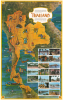
This is a 1966 Mike Roberts pictorial map of Thailand, published near the height of the Vietnam War (1955 - 1975), when Americans had a growing interest in Southeast Asia. Throughout the war, the U.S. Air Force and Navy used Thai bases, and American servicemen became enamored of the beautiful country as a destination for Rest and Recreation.A Closer Look
Thailand, highlighted in a warm gold, lifts off the page. Vignette illustrations include temples, elephants, water buffalo, a tiger, fishermen, a spirit, and traditional dancers. More ominously, a black-clad Viet Cong soldier with a bayonet appears near Nakhon Phanom, the border with Laos. Key cities and towns are labeled, including Bangkok and Phuket, connected by the regional road network. Rivers and canals in Bangkok stand out in blue. Photographs in the lower right capture street scenes, temples, and elephants, reinforcing the exoticism that entranced Roberts' American audience. A short text in the cartouche praises the peaceful and artistic temperament of the Thai people.Publication History and Census
This map was published in 1966 by Mike Roberts Color Productions. Roberts made similar maps of the Philippines and South Vietnam - both locations that would have resonated with American servicemen during the Vietnam War. Of the present map, this is the only known example.
Cartographer
Mike Roberts (19xx - 1989) was an American photographer and publisher, and was known as 'America's Postcard King'. Roberts left home at sixteen with twenty-five dollars, a box camera, and his Harley. Roberts arrived in the Bay Area in 1934 and began working as a photographer in Berkeley. By 1941 he was a partner in the Litho Screen Company in Oakland, which was also likely his first venture into the printing trade. Robert's first traceable postcard is postmarked June 12, 1945, and bears one of his photographs of the Yosemite Valley. Roberts used a handful of different publishers before he founded 'Mike Roberts Color Productions' in 1949, which marks his move into the world of commercial postcard production. Over the course of his career, Roberts used numerous different logos and his postcards were published by several different publishers. Roberts died in 1989 and his company continued operating until 1998. Further Details...
Condition
Very good. Light wear along original fold lines.