This item has been sold, but you can get on the Waitlist to be notified if another example becomes available, or purchase a digital scan.
1900 Deasy Map of Tibet and Xinjiang, China
TibetSinChiang-deasy-1900$187.50

Title
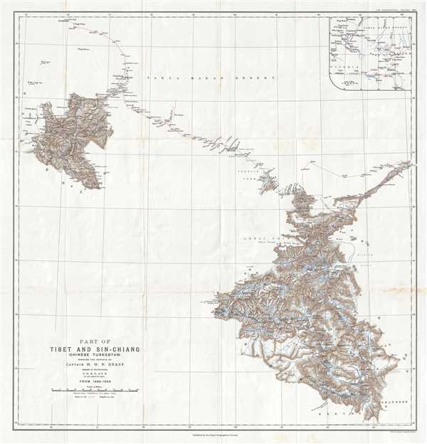
Part of Tibet and Sin-Chiang (Chinese Turkestan) Showing the Surveys of Captain H. H. P. Deasy.
1900 (dated) 23.75 x 22.25 in (60.325 x 56.515 cm) 1 : 1500000
1900 (dated) 23.75 x 22.25 in (60.325 x 56.515 cm) 1 : 1500000
Description
This is a 1900 Henry Hugh Peter Deasy map of Tibet and Xinjian (Sin-Chiang), China illustrating Deasy's exploration in the region. The map depicts the region from the Taghdumbash Pamir to the Tolan Khoja River and from Kashgar, China to the Yarkand Valley. Upon retiring from the British army in India, Deasy spent three years exploring this part of Asia and surveying the territory. By 1899, when he finished his wanderings, he had surveyed over 40,000 square miles of new territory. Illustrated by a red line, Deasy surveyed some of the harshest, most mountainous terrain on the planet, and did so in a professional manner. For his work he was recognized with the Founder's Medal by the Royal Geographical Society.
This map was produced by Henry Hugh Peter Deasy and published by the Royal Geographical Society in November 1900.
This map was produced by Henry Hugh Peter Deasy and published by the Royal Geographical Society in November 1900.
CartographerS
Henry Hugh Peter Deasy (1866 - February 1947) was an Irish army officer, amateur explorer, writer, and founder of the Deasy Motor Car Company. Born in Dublin, Deasy served as a British Army Captain, mostly in India, from 1888 until 1897. After retiring from the army, he became one of the first westerners to write a detailed account of Tibet, detailing his travels between 1897 and 1899. He was awarded the Royal Geographical Society’s Founder’s Medal in 1900 in recognition of his work surveying nearly 40,000 square miles of the Himalayas. In 1901 he published a book about these travels entitled In Tibet and Chinese Turkestan: Being the record of three years Exploration. Following his exploits in Asia, his interest turned to motor cars. In 1903, he drove a car from London to Glasgow to promote the Rochet-Schneider Company and is also remembered for driving a Martini car up a mountain rock railway near Montreaux, Switzerland. He founded H. H. P. Easy and Company around 1903 to import both Rochet-Schneider and Martini cars into the U.K., and in 1906 he formed the Deasy Motor Company. Deasy left the company in 1908 due to frequent clashes with the chief designer. He married Delores Hickie and had three children. More by this mapmaker...
Royal Geographical Society (fl. 1830 - present) is a British Society established in 1830 to promote geographical science and exploration. Originally titled the "Geographical Society of London", the RGS received its royal charter from Queen Victoria in 1859 shortly after absorbing several similar but more regional societies including the African Association, the Raleigh Club and the Palestine Association. The RGS sponsored many of the most important and exciting voyages of exploration ever undertaken, including the exploration of Charles Darwin, David Livingstone, Robert Falcon Scott, Richard F. Burton, John Speke, George Hayward, H. M Stanley, Ernest Shackleton and Sir Edmond Hillary. Today, the RGS remains a leading global sponsor of geographical and scientific studies. The Society is based in Lowther Lodge, South Kensington, London. Learn More...
Alexander Keith Johnston (December 28, 1804 - July 9, 1871) was a Scottish cartographer and map publisher active in the middle portion of the 19th century. Johnson was born at Kirkhill, near Edinburgh, Scotland. He studied at the University of Edinburgh where he apprenticed as an engraver. Around 1826, in partnership with his brother William, he founded a cartographic printing and engraving firm with the imprint "W. and A. K. Johnston." Johnston made a name for himself in educational geography, publishing numerous maps for use in schools. His brother, William Johnston, eventually left the firm to pursue a career in politics, eventually becoming the Lord Provost of Edinburgh. Alexander's son, who would bear the same name, became a geographer and explorer, suffering an untimely death on the Royal Geographical Society's 1879 expedition to Lake Nyasa. Learn More...
Source
The Geographical Journal Vol. XVI, No. 5, November 1900.
Condition
Very good. Wear along original fold lines. Foxing. Blank on verso.
References
OCLC 144627200.