1544 / 1552 Sebastian Münster Map of Transylvania, after Honter
Transylvania-munster-1552$850.00

Title
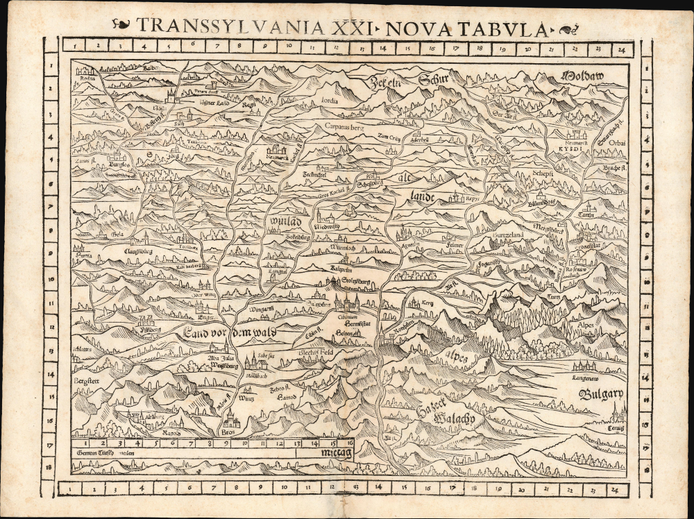
Transsylvania XXI. Nova Tabula.
1552 (undated) 11.5 x 14.75 in (29.21 x 37.465 cm) 1 : 680000
1552 (undated) 11.5 x 14.75 in (29.21 x 37.465 cm) 1 : 680000
Description
This is a superb example of Sebastian Münster's modern map of Transylvania (part of modern-day Romania) in the desirable 1552 Geographia edition, the only one to include distinctive coordinate borders. It is the earliest acquirable derivative of Johannes Honter's foundational 1532 map of his homeland, Chorographia Transylvaniae. Sybembürgen. Honter's work, a woodcut printed on two sheets, was the first printed map of Transylvania, but Honter was dissatisfied with his work and suppressed it, resulting in the survival of only a single example. Münster's single-sheet copy of Honter's map, first appearing in the 1544 edition of Cosmographia, is thus the earliest acquirable iteration of the first map of this region.
This map appeared first in the 1544 debut edition of Münster's Cosmographia, remaining in that work until 1548. Oddly, it was not included in the 1550 overhaul of the opus, and did not reappear in that work until the 1569 edition, long after the author's death. It would, however, appear as a tabula moderna in both the 1545 and 1552 editions of Geographia; the present example hails from the latter, exhibiting the added coordinate bars characteristic of that edition. Its absence from so many editions of Cosmographia results in this being one of Münster's scarcer maps.
A Closer Look
Münster's woodcut map, oriented to the north, is evocative of Transylvania's densely forested Carpathian terrain. Cities and towns are shown pictorially. The map spans from Bulgaria in the east, and remains within the borders of modern-day Romania in the west. Münster here names the Carpathians as Transylvania's 'Alpes.' The cities of Cluj-Napoca (Clausenburg), Hermannstadt (Sibiu), Corona (Kronstadt/Brasov), and Țara Bârsei (Burtzeland) are identified, among others.Earliest Glimpse of Transylvania
Münster's Geographia and Cosmographia provided literate Europeans with their only glimpses of the world for many years, and these two works contained several maps with previously unseen, contemporaneous knowledge. For Münster's readership, this map was the first depiction of Transylvania to be published. Honter's original, despite its long-term influence, was seen by almost nobody during its author's lifetime. Waldseemüller's 1513 Tabula Moderna Sarmatiae Eur. Sive Hungariae Poloniae Russie Prussie et Walachie is the first modern map to name Transylvania. Transylvania was likewise named on Münster's 1540 map of Poland and Hungary, which was based on Bernard Wapowski's lost 1526 map; however, these were extremely broad works and contained virtually no detail of Transylvania specifically. Honter both lived in the region he mapped and also had access to locally produced manuscript maps, so not only was his cartography more detailed than anything printed prior, but it was also more credible.This map appeared first in the 1544 debut edition of Münster's Cosmographia, remaining in that work until 1548. Oddly, it was not included in the 1550 overhaul of the opus, and did not reappear in that work until the 1569 edition, long after the author's death. It would, however, appear as a tabula moderna in both the 1545 and 1552 editions of Geographia; the present example hails from the latter, exhibiting the added coordinate bars characteristic of that edition. Its absence from so many editions of Cosmographia results in this being one of Münster's scarcer maps.
Publication History and Census
Cut by an anonymous formschneider, this map was prepared for inclusion in the first edition of Münster's Cosmographia in 1544. The present example is distinguished by the coordinate bars at the margins, conforming typographically to the 1552 Geographia edition. This edition of Geographia Universalis is catalogued in 27 institutional collections. We see four examples of this edition of the separate map in OCLC, although it appears on the market from time to time.CartographerS
Sebastian Münster (January 20, 1488 - May 26, 1552), was a German cartographer, cosmographer, Hebrew scholar and humanist. He was born at Ingelheim near Mainz, the son of Andreas Munster. He completed his studies at the Eberhard-Karls-Universität Tübingen in 1518, after which he was appointed to the University of Basel in 1527. As Professor of Hebrew, he edited the Hebrew Bible, accompanied by a Latin translation. In 1540 he published a Latin edition of Ptolemy's Geographia, which presented the ancient cartographer's 2nd century geographical data supplemented systematically with maps of the modern world. This was followed by what can be considered his principal work, the Cosmographia. First issued in 1544, this was the earliest German description of the modern world. It would become the go-to book for any literate layperson who wished to know about anywhere that was further than a day's journey from home. In preparation for his work on Cosmographia, Münster reached out to humanists around Europe and especially within the Holy Roman Empire, enlisting colleagues to provide him with up-to-date maps and views of their countries and cities, with the result that the book contains a disproportionate number of maps providing the first modern depictions of the areas they depict. Münster, as a religious man, was not producing a travel guide. Just as his work in ancient languages was intended to provide his students with as direct a connection as possible to scriptural revelation, his object in producing Cosmographia was to provide the reader with a description of all of creation: a further means of gaining revelation. The book, unsurprisingly, proved popular and was reissued in numerous editions and languages including Latin, French, Italian, and Czech. The last German edition was published in 1628, long after Münster's death of the plague in 1552. Cosmographia was one of the most successful and popular books of the 16th century, passing through 24 editions between 1544 and 1628. This success was due in part to its fascinating woodcuts (some by Hans Holbein the Younger, Urs Graf, Hans Rudolph Manuel Deutsch, and David Kandel). Münster's work was highly influential in reviving classical geography in 16th century Europe, and providing the intellectual foundations for the production of later compilations of cartographic work, such as Ortelius' Theatrum Orbis Terrarum Münster's output includes a small format 1536 map of Europe; the 1532 Grynaeus map of the world is also attributed to him. His non-geographical output includes Dictionarium trilingue in Latin, Greek, and Hebrew, and his 1537 Hebrew Gospel of Matthew. Most of Munster's work was published by his stepson, Heinrich Petri (Henricus Petrus), and his son Sebastian Henric Petri. More by this mapmaker...
Johannes Honter (1498-1549) was a Transylvanian cartographer, born in Kronstadt (now Brasov, Romania.) Nothing is known of his youth, but he was sufficiently educated to enroll in the university of Vienna in 1515, and receive his bachelor's degree in 1517 and his master's in 1525. The university was rich in humanists and cosmographers; he was a classmate of Peter Apian. It is just as well he was there: in the 1520s Transylvania under assault by the Turkish Army, and the Hungarian army was knocked back on its heels. He eventually had to flee Vienna in the face of the 1529 Turkish siege of the city. The next year would find him at the University of Krakow; while there he published a grammar and his cosmography, Ioannis Honter Coronensis Rudimentorum cosmographiae... In 1531 he traveled to Basel, to work as a proofreader. While there, he met Simon Grynaeus and publisher Heinrich Petri, as well as Sebastian Münster. He appears to have worked as a formschneider in Basel as well. His first full size map was his 1532 Chorographia Transylvaniae, Sybembürgen, the first printed map of that region. But he was unsatisfied with the work and prevented it from being broadly distributed. Only a single copy of the map survives, although a copy appears to have reached at least Joahannes Sambucus, whose Transylvania map copied Honter's. It also constituted the basis for Sebastian Münster's map of the place. Ortelius' maps of Transylvania, though credited to Sambucus, can be recognized as containing Honter's cartography. He would return to Kronstadt in 1533, where he would become involved in public affairs, and would work to establish Lutheranism in his homeland. To this end he started a school and a printing press. He did not neglect cosmography: he published a verse cosmography in 1542 which contained thirteen woodcut maps, which he executed himself. Learn More...
Heinrich Petri (1508 - 1579) and his son Sebastian Henric Petri (1545 – 1627) were printers based in Basel, Switzerland. Heinrich was the son of the printer Adam Petri and Anna Selber. After Adam died in 1527, Anna married the humanist and geographer Sebastian Münster - one of Adam's collaborators. Sebastian contracted his stepson, Henricus Petri (Petrus), to print editions of his wildly popular Cosmographia. Later Petri, brought his son, Sebastian Henric Petri, into the family business. Their firm was known as the Officina Henricpetrina. In addition to the Cosmographia, they also published a number of other seminal works including the 1566 second edition of Nicolaus Copernicus's De Revolutionibus Orbium Coelestium and Georg Joachim Rheticus's Narratio. Learn More...
Source
Münster, Sebastian, Geographia Universalis, (Basel: Petri) 1552.
Following in the footsteps of Martin Waldseemuller and Lorent Fries before him, Sebastian Munster edited and published a modernized version of Claudius Ptolemy's Geographia. This appeared in six Latin editions in 1540, 1541, 1542, 1545, 1551 and 1552. According to Karrow, Munster based the text on the Latin translation of Willibald Pirkheimer, but he carefully collated it with previous editions, adding notes of his own. The first three editions contained 48 maps, consisting of 27 based on Ptolemy's ancient geography, and 21 maps based on modern geographical knowledge. The latter three editions contained 54 maps, comprised of the same ancient works but with six of the modern maps discarded, and twelve new ones added. For the collector, the modern maps are of sharpest interest. Some were based on Waldseemuller's geography, but many were based on Munster's own surveys and those of other European geographers whose assistance Munster had been able to enlist. Most of these would be reprised in Munster's magnum opus, Cosmographia Universalis. A disproportionate number of Munster's modern maps show contemporary geographical knowledge of the their respective areas for the very first time: The first map to show the continents of the Western Hemisphere; the first map to focus on the continent of Asia; the first modern map to name the Pacific Ocean. Even in cases where earlier maps exist, Munster's works very often remain the earliest such acquirable by the collector.
Condition
Very good. Minor mend to bottom centerfold, else excellent.
References
OCLC 165596070. Karrow, R., Mapmakers in the Sixteenth Century, 58/126.