1879 Atkinson / Survey of India 'Great Game' Map of Central Asia
Turkestan-atkinson-1879$1,800.00

Title
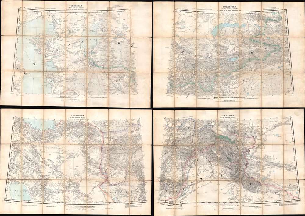
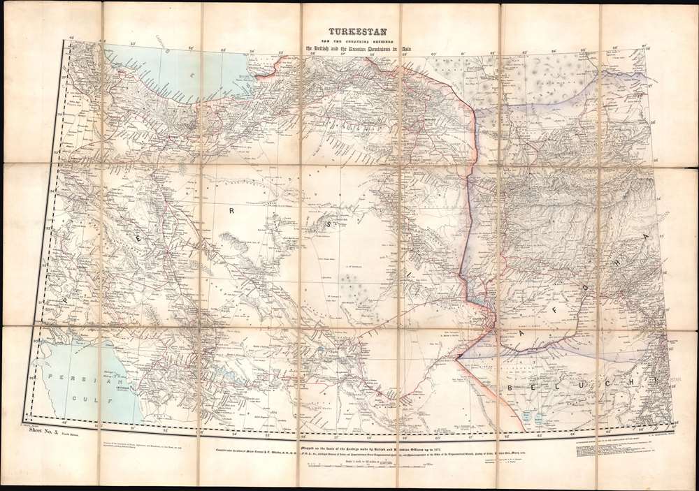
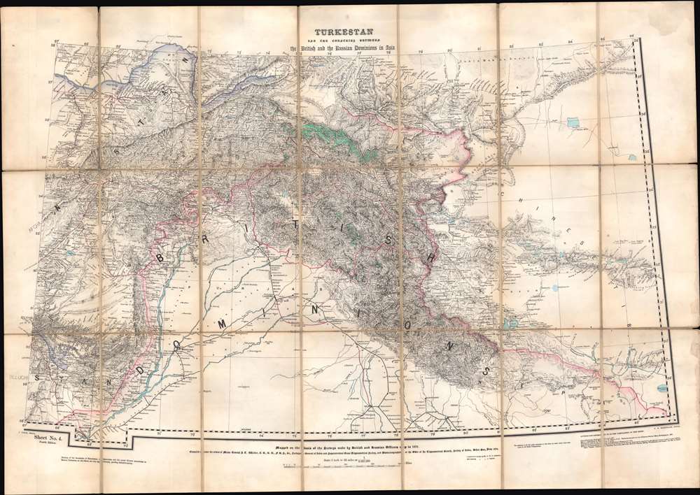
Turkestan and the countries between the British and the Russian Dominions in Asia.
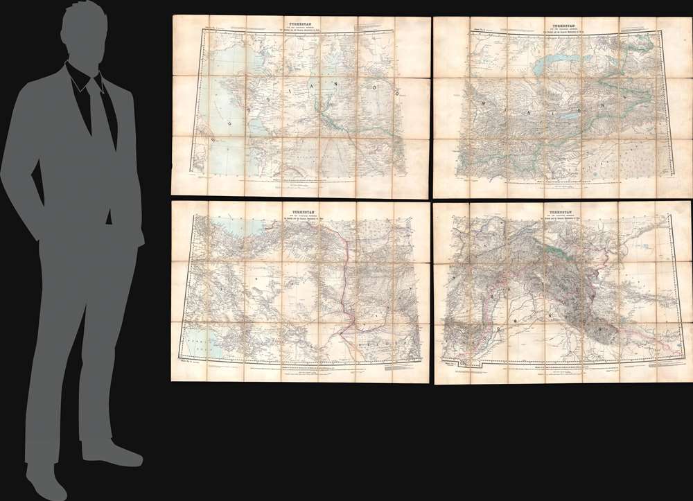
1879 (undated) 59 x 80 in (149.86 x 203.2 cm) 1 : 2027520
1879 (undated) 59 x 80 in (149.86 x 203.2 cm) 1 : 2027520
Description
This is a fascinating 1879 map of Central Asia, divided into four large folding sheets, produced by G.W.E. Atkinson, a British Survey of India expert on Tibet, the Himalayas, and Central Asia. It was produced at the height of the 'Great Game' and intended for use by the government and military of British India. This map provides unique insight into the collaborative process of Russian and British surveyors operating in Central Asia despite ongoing political conflict.
Using the latest military, communication, and transportation technology, the Russian Empire focused intently in the mid-19th century on subjugating Central Asia. Although the region had lost some of its wealth and luster from the height of the Silk Road, it was still home to powerful states that held their own in skirmishes with neighboring empires in the 18th and early 19th centuries. The Russians encountered difficulties controlling the region, starting with a disastrous 1839 attack on Khiva. (Khiva was eventually conquered in 1873). Rather than military strategy or technology, the main obstacle for the Russians was supplying troops so far from the Russian heartland in a region with minimal infrastructure. Getting supplies to the main staging area at Orenburg was difficult enough, but then they needed to be moved across vast distances through desert and steppe. What could not be moved up rivers had to be carried over land, usually by caravans of horses, oxen, and camels, which required their own food and water.
Thus, Russian progress into Central Asia was slow but consistent and ultimately aided by tensions between independent states. It was only in the final stage of the Russian conquest that railways reached deep into Central Asia, greatly facilitating the regional control and the arrival of Russian colonists.
The impact of the Russian conquest on these areas was tremendous. Previously, the region was tied together by trade and religious networks (particularly Sufi orders) stretching from the Ottoman Empire to Qing China. The Russians brought notions of modern ethnic and national identity and imposed complex cultural identities that defied easy categorization. (There was a great deal of uncertainty on the part of the Russians over the exact differences between 'Tatars,' 'Turks,' 'Kazakhs,' 'Kirghiz,' and other groups.) This project carried over into the Soviet era, when the contrived, externally imposed ethnic identities were emphasized, and the Central Asian Soviet Socialist Republics were arranged in a way to prevent pan-Islamic and pan-Turkic movements from gaining ground.
A Closer Look
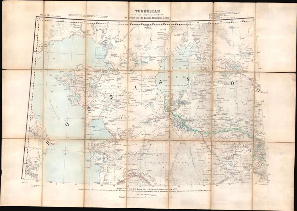
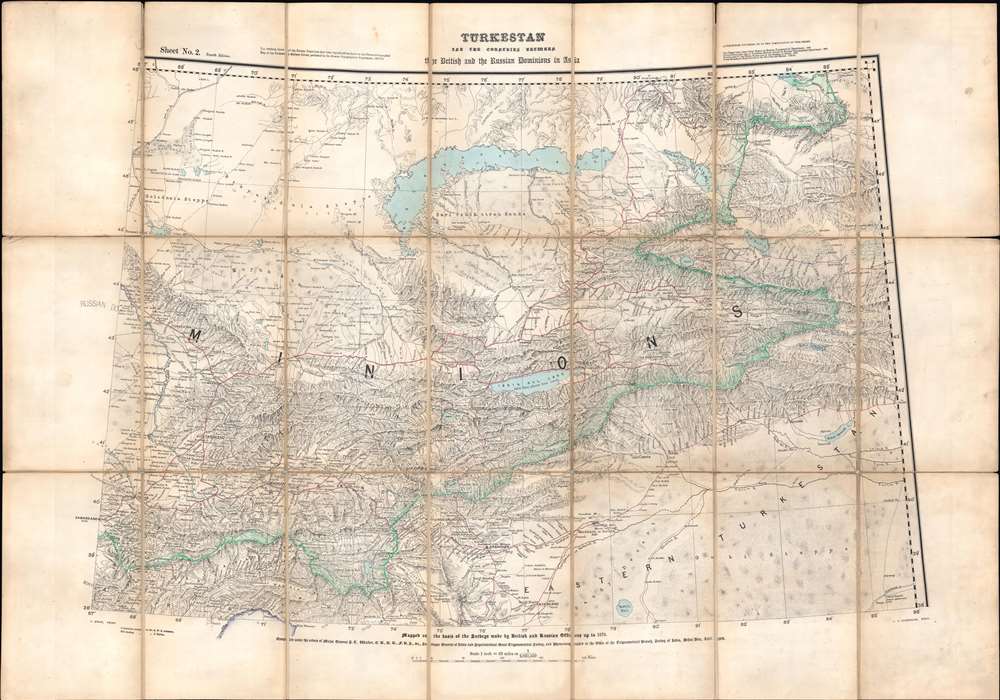
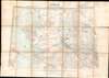
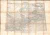
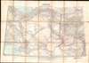
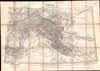
The map is divided into four sheets, each roughly 29 x 40 inches: the first (top-left) includes the Caspian and Aral Seas and takes in Khiva, Bukhara, and Samarkand in the western part of modern Kazakhstan and Uzbekistan; the second (top-right) includes Lake Balkhash, the Tianshan mountains, and the western part of Eastern Turkestan (also known as Chinese Turkestan or Xinjiang), taking in Turkestan (Turkistan), Kuldja (Ghulja), Jizzakh, and the settlements in the western parts of the Tarim Basin (Kashgar, Yarkand, Aksu, and Kuchar); the third (bottom-left) covers much of Persia and the western half of Afghanistan as well as part of Baluchistan; and the fourth (bottom-right) ranges from the eastern half of Afghanistan, through the northern portion of British India, the Hindu Kush and Pamir Mountains, and to the western part of the Himalayas and Tibet.Sources - An Imperial Exchange
The number of sources drawn on attest to the importance of the accuracy of this map. In particular, the Survey of India used Russian [Army] Topographical Department maps to compile their own maps, and the Russians likewise used British maps to improve theirs. In fact, despite the competition between the imperial superpowers, cartographers and explorers from both sides were quite ready to exchange information, motivated by a shared interest in improving geographical knowledge. Accurate geographical knowledge was an important factor in preventing a wider conflict. A series of agreements between the Russians and British beginning in 1873 defined the region's borders and helped develop a buffer zone between British and Russian spheres.But - Back to Conflict
Still, Russian expansion and British finagling of local rulers made for rapid territorial changes. Also, at this time, Qing China had just reconquered Eastern Turkestan (Xinjiang) after a series of large revolts, and in the following decades, would seek to dissuade British and Russian adventurism in Xinjiang and Tibet.Russia's Conquest of Central Asia
Russian contacts with Central Asia predated this map by many centuries, and Russian national identity is largely rooted in the relationship with the steppe and interaction (trade, warfare, etc.) with steppe-dwelling peoples. In the 17th and 18th centuries, the Russian Empire established a series of border forts that roughly followed the edge of the forested land before reaching the steppe, concurrent with the present-day border between the Russian Federation and Kazakhstan. Occasional forays into the steppes were attempted, but conquering those territories in any meaningful sense remained elusive.Using the latest military, communication, and transportation technology, the Russian Empire focused intently in the mid-19th century on subjugating Central Asia. Although the region had lost some of its wealth and luster from the height of the Silk Road, it was still home to powerful states that held their own in skirmishes with neighboring empires in the 18th and early 19th centuries. The Russians encountered difficulties controlling the region, starting with a disastrous 1839 attack on Khiva. (Khiva was eventually conquered in 1873). Rather than military strategy or technology, the main obstacle for the Russians was supplying troops so far from the Russian heartland in a region with minimal infrastructure. Getting supplies to the main staging area at Orenburg was difficult enough, but then they needed to be moved across vast distances through desert and steppe. What could not be moved up rivers had to be carried over land, usually by caravans of horses, oxen, and camels, which required their own food and water.
Thus, Russian progress into Central Asia was slow but consistent and ultimately aided by tensions between independent states. It was only in the final stage of the Russian conquest that railways reached deep into Central Asia, greatly facilitating the regional control and the arrival of Russian colonists.
The impact of the Russian conquest on these areas was tremendous. Previously, the region was tied together by trade and religious networks (particularly Sufi orders) stretching from the Ottoman Empire to Qing China. The Russians brought notions of modern ethnic and national identity and imposed complex cultural identities that defied easy categorization. (There was a great deal of uncertainty on the part of the Russians over the exact differences between 'Tatars,' 'Turks,' 'Kazakhs,' 'Kirghiz,' and other groups.) This project carried over into the Soviet era, when the contrived, externally imposed ethnic identities were emphasized, and the Central Asian Soviet Socialist Republics were arranged in a way to prevent pan-Islamic and pan-Turkic movements from gaining ground.
The Great Game
This map was made in the context of the height of the 'Great Game,' a diplomatic confrontation between the British and Russian Empires over territories in Central and Southern Asia. The conflict revolved around Afghanistan, which, while lacking significant resources of its own, was strategically situated. Russia feared Britain was making commercial and military inroads into Central Asia, an area long within the sphere of influence of St. Petersburg. Britain, conversely, feared Russia making gains in India, 'the jewel in the crown' of British Asia. The escalating tensions led to several wars and proxy wars in India and Afghanistan, were connected with the Russian annexations of Khiva, Bukhara, and Kokand, and tied to wider geopolitical tensions between Russia and Britain, evident in the Crimean War and elsewhere.The Great Trigonometrical Survey
The Great Trigonometrical Survey was a massive and ambitious undertaking to map the Indian subcontinent, which started as an independent project but was folded into the preexisting Survey of India under the leadership of Sir George Everest (namesake for the mountain). As much of the Indian subcontinent had been thoroughly mapped by the mid-19th century, the Great Trigonometrical Survey focused more on the Himalayas and areas beyond British control. As the British and Russian Empires drew closer to each other in Inner Asia in the 19th century, the challenge of mapping out the intermediate regions was of critical importance in trying to gain an advantage. In the end, these surveys led to important scientific advances (in geography, cartography, and navigation) that were driven by geopolitical competition akin to the space race of the 1950s - 1960s.Publication History and Census
This map was compiled by G. W. E Atkinson under the orders of Gen. J. T. Walker, the Surveyor General of India. Other employees of the Survey of India were responsible for the shading of hills (J. Peyton) and photozincography (C. Dyson and C. G. Ollenbach). Although undated, from context, it can be inferred that this is the 1879 edition of the map, which was first published in 1875 and subsequently published in 1879, 1881, 1883, and 1885 (the last edition being a reprint of the 1875 edition in Washington D.C. by the Office of the Chief of Engineers, U.S. Army). The only known institutional holdings of the present edition are part of the collections at the Boston Public Library, the National Library of Wales, and Victoria University of Wellington.CartographerS
G.W.E. Atkinson (fl. c. 1859 – 1898) was a British military surveyor and expert on Tibet, the Himalayas, and Central Asia who worked with the Survey of India in the late 19th century. He first joined the Survey in 1859 and worked his way up the ranks, eventually becoming a Surveyor of the First Grade in the Drawing Office in Simla and later Assistant Superintendent of the same office in 1894, retiring in October 1898 and eventually receiving the rank of Esquire in 1901 in recognition of his services. He was considered an expert on 'transfrontier geographical mapping' and published several accounts of Indian and Tibetan pundits who had explored Tibet and neighboring regions for the British (most notably Narrative Account of Rinzin Nimgyl's Explorations in Sikkim , Bhutan and Tibet , in 1885-86). He also produced important maps on Kashmir (Map of Kashmir, 1873), Central Asia (Turkestan: and the countries between the British and the Russian dominions in Asia, first edition 1875), and a series of gazetteer maps. More by this mapmaker...
Survey of India (1767 - Present) is India's central engineering agency in charge of mapping and surveying the country. It was founded in 1767 by Major James Rennell, who took the post of first Surveyor General, with the mission to map and consolidate the territories of the British East India Company. The Survey undertook the Great Trigonometrical Survey between 1802 and 1852 in an attempt to accurately measure the Indian Subcontinent - considered one of the greatest feats of mapping of all time. It also sponsored clandestine surveys, at times disguised as Buddhist pilgrims, to infiltrate and map Tibet, then a closed country. With India's independence in 1947, the Survey was folded into the new Indian government, which it remains part of to this day. Learn More...
James Thomas Walker CB FRS (December 1, 1826 – February 16, 1896) was an Anglo-Indian Surveyor General of India. He was born at Cannanore, the son of John Walker of the Madras civil service and educated in Wales and at the military college of the East India Company. He was commissioned as a second lieutenant in the Bombay Engineers and served in a number of campaigns in the Second Anglo-Sikh War. From 1849 to 1853 he took part in a reconnaissance of the frontier of Peshawar, and served as field-engineer during the Indian mutiny in 1857, during which his exploits (destroying the gates of a fortress, setting off gunpowder charges with his musket, for example) earned him his promotion to captain. Following the mutiny he resumed work on the Indus survey, before being appointed to the Great Trigonometrical Survey in 1860. In March 1861 he would become superintendent of the Survey, completing his surveys with astounding accuracy, and undertaking revisions of earlier surveys to increase precision. In 1878 he became Surveyor General of India, retiring at the rank of lieutenant-general in 1883. Among his achievements as Surveyor General was his remarkable openness to the trade of geographical data with the Russians, at the height of Britain's 'Great Game' rivalry with that empire. As a token of this cooperation, Walker - already a fellow of the Royal Geographical Society since 1859 - would be made a member of the Russian Geographical Society in 1868. Learn More...
Condition
Good. Some wear and loss along fold lines and at fold intersections.
References
OCLC 1118069314.