1795 Carey / Barker Map of Ottoman Europe (the Balkans, Greece) and Hungary
TurkeyHungary-carey-1795$400.00

Title
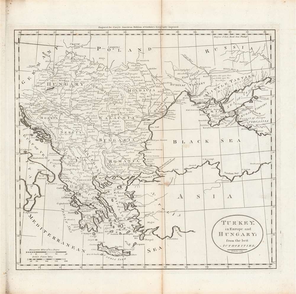
Turkey in Europe and Hungary; from the best authorities.
1795 (undated) 12.5 x 14 in (31.75 x 35.56 cm) 1 : 6336000
1795 (undated) 12.5 x 14 in (31.75 x 35.56 cm) 1 : 6336000
Description
This is Matthew Carey and William Barker's c. 1795 map of Ottoman Europe, Hungary, and nearby territories in southeastern Europe, made for Carey's General Atlas. It depicts the region as it was just prior to a major rearrangement that would see Ottoman rule over the European portion of its empire collapse.
A Closer Look
Coverage includes Hungary, the Balkans, Greece, and territories that today compose Bulgaria, Romania, Moldova, and Ukraine. Waterways, mountains, cities, administrative borders, and regions appear in extensive detail. Scales are provided in Hungarian miles and British statute miles. Bulgaria and Romania are reversed from their actual locations, a curious error which remained in later editions.The Decline of Ottoman Europe
Often remembered as the 'sick man of Europe,' the Ottoman Empire went through a long period of unrest and dissolution from the late 18th through the early 20th century. In fact, there were several important reform efforts that might have forestalled the empire's disintegration, but they were hindered by opposition from entrenched interests. The Ottoman's main problem was dealing with an increasingly powerful Russia to its north while also managing potential threats from Austria and other nearby powers, especially as Russia and Austria were allied for much of the 18th century. Although on the defensive, the Ottomans were able to do so for the first half of the 18th century, but the disastrous Russo-Turkish War of 1768 - 1774 led to the loss of Crimea, and another war against Russia from 1787 until 1792 led to further losses along the Black Sea. The Ottomans also had to contend with rising discontent among subject populations, including a 1769 - 1772 revolt in Egypt and periodic Greek uprisings, harbingers of greater troubles to come. By the 1830s, Ottoman rule over most of the territory seen here would be seriously threatened or eliminated entirely.Publication History and Census
This map was engraved by William Barker for the 1795 or 1796 edition of Carey's General Atlas (sometimes subtitled American Edition of Guthrie's Geography improved). Its distribution is difficult to firmly establish, both due to uncertainty over its date and because the OCLC catalog listing includes digitized copies along with physical examples. The map is listed among the holdings of the American Antiquarian Society, while the entire atlas is held by a handful of universities and research institutions in the United States and Europe.CartographerS
Matthew Carey (January 28, 1760 - September 16, 1839) was a Dublin born publisher who established himself in Philadelphia in the late 18th and early 19th century. A young man of socially progressive views, Carey's first known publication, produced when he was but 17 years old, was a pamphlet criticizing dueling. Another pamphlet, issued in the same year, attacked the Irish penal code. Shortly afterwards, in 1779, legal issues, possibly arising from his liberal political activism, forced Carey to flee to Paris. In Paris, Carey had the good fortune to befriend the visiting American diplomat and founding father, Benjamin Franklin (1706 - 1790). As an Irishman chafing under the rule of England, Carey sympathized with and admired the American revolutionary. The liberally minded pair struck up a lifelong friendship and Carey was hired to work at Franklin's press in Passy, France. A year later, Carey returned to Ireland and resumed his politically provocative publishing career with The Freemans's Journal and The Volunteer's Journal. It didn't take long for political pressure to once again force Carey from Ireland - this time to America (1784). Although largely without funds, Carey convinced Gilbert du Motier, Marquis de Lafayette (1757 - 1834), who he knew from Franklin's Paris circle, to lend him funds to establish a new publishing concern in Philadelphia. Despite this loan, Carey's firm remained under financed and opened on a shoestring budget. It was most likely his limited budget that led Carey to some of his most important publishing innovations. At the time cartographic publishing was dominated by large printing houses in London and Paris where most, if not all, of the work was completed in house. Without the finances to emulate this large publishing houses, Carey was forced to outsource much of his publishing work. This set the stage for subsequent American publishers who, in order to compete effectively with European firms, relied on an often bewildering network of alliances and collaborations. Carey was also a master of republishing many of his own maps in multiple different atlases and formats to maximize their profitability. His most important work is without a doubt the 1795 issue of the American Atlas the first atlas to be published in America. Carey died in 1839 but was succeeded by his son Henry Charles Carey (1793 - 1879) who, in partnership with his brother-in-law Isaac Lea (1792 - 1886), published numerous important maps and atlases under the Carey and Lea, Lea Brothers, and Lea and Blanchard imprints. More by this mapmaker...
William Barker (June 29, 1770 - April 19, 1805) was an engraver active in Philadelphia un the late 18th and early 19th centuries. Barker was born in Philadelphia, the son of Elihu Barker (17?? - 1792). Both father and son worked for the firm of Mathew Carey (1760 - 1839) and engraved maps for Carey's American Atlas, considered the first general atlas published in America. He appears in Philadelphia directories for 1795 - 1796 and 1800 - 1809. His business may have been carried on by a son of the same name, but it is unclear. Learn More...
William Guthrie (1708 - March 9, 1770) was a Scottish historian, journalist, and writer. Born in Brechin, he studied at Aberdeen University with the idea of becoming a parochial schoolmaster. Instead, in 1730, he elected to settle in London and try his hand at literature. He covered parliamentary debates f or the Gentleman's Magazine and soon earned a reputation for being a political writer. He published several scholarly works, including a History of England from the Invasion of Julius Caesar to 1688 in four volumes, and, most notably, his Geographical Historical, and Commercial Grammar. Learn More...
Source
Carey, M., Carey's General Atlas, (Philadelphia: Carey) 1796.
Condition
Good. Discoloration along the centerfold. Wear along the centerfold at margins. Slight foxing at upper-left margin.
References
Rumsey 2862.014 (1796 edition). OCLC 793032211, 53047069.