1684 Cantelli / De Rossi Map of Ukraine and Crimea
UkraineCaucasus-cantellirossi-1684$1,200.00
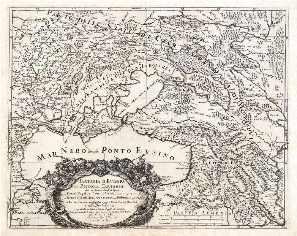

Title
Tartaria d'Europa o vero Piccola Tartaria divisa da Giacomo Cantelli da Vignola ne Tartari Nogai e del Crim, o di Precop Soggetti al proprio Kam ne Tartari di Budziack, d'Oczackow, e di Dobruss, soggetti al Turco, ne Tartari Circassi, e di Mordua Soggetti al Gran Duca di Moscovia e nelle Due Uckraine...
1684 (dated) 17.5 x 22 in (44.45 x 55.88 cm) 1 : 4500000
1684 (dated) 17.5 x 22 in (44.45 x 55.88 cm) 1 : 4500000
Description
This is a 1684 Cantelli da Vignola map of the Caucasus, the lands of the Circassian and Crimean Tartars, Georgia, and Ukraine. The region - peopled by an array of Tatar and Cossack tribes - was largely under the domination of the Crimean Khanate and the Nogai Horde, but represented a borderland contested by the Grand Duchy of Muscovy and the Turkish Empire.
Ukraine
The region surrounding the lower Dnieper River is here identified as Ukraina ó Paese de Cosacchi di Zaporowa, that is to say the country of the Zaporozhian Cossacks. As recently as the end of the 16yth century, these were considered subjects of the Polish-Lithuanian Commonwealth, at least to the extent that they chose to raid the Ottoman Empire, as Tatars subject to the Ottomans raided the Commonwealth. Indeed, in 1615 and 1625 the Cossacks were burning Constantinople's suburbs, forcing the Sultan to flee. Following the Polish-Ottoman War of the 1670s, the famed intransigence of the Zaporozhian Cossacks were immortalized in the justifiably long-lived, hilarious literary forgery of the Correspondence between the Ottoman Sultan and the Cossacks.The Russian Frontier
The map captures the region during the dual regency of Peter (the Great) and his elder brother Ivan, with power in the hands of their half-sister Sophia Alekseyevna (1657 - 1704). She wrested the regency from Peter's mother in a temporarily successful bid to prevent Peter from bypassing his brother and inheriting the throne. Between 1682 and 1689, Sophia ruled as an autocrat behind her puppet brothers. Despite her canny political sense, and the support of the Streltsy, her reign was marked and weakened by unsuccessful efforts to defeat the Crimean Khanate, who raided southern Russia with impunity. It was not until the 1690s that Peter, as Tsar, captured the fortress of Azov from the Crimean Khan Tatars and the Ottoman Sultan, thus taking control of the Don River. On Cantelli's map, Azov is marked with the symbol of the crescent, signifying its allegiance to the Turkish Empire.A Much-Updated Work
Cantelli is notable for his efforts to reconcile conflicting modern and classical information. According to Chikobava, (2006) the place names employed in the vicinity of Georgia, particularly the Principalities of Odishi and Guria, indicate that Cantelli's map reflected the conquest of Guria by Georgian leader Levan II Dadiani (1611 - 1657). Thus, despite many map features being drawn from antique sources, Cantelli also updated his work with recent data. This would have been significant, as the region's primary characteristic is one of turmoil: the allegiances, territorial holdings, and borders were in constant flux.Sevastopol?
The place name Sevastopol appears in two different forms on this map, and in two separate locations. Sixteenth and seventeenth century maps show a Black Sea port of Savatopolis in the vicinity of modern-day Sukhumi (also named Dioscurias by the Greeks; Ortelius' Pontus Euxinus uses both Savatopolis and the Greek term; Cantelli's map places Savatopoli). Both Ortelius and Cantelli apply the name Sebastopoli to the city of Faso at the mouth of the Rioni river. Modern day Sevastopol did not exist at the time this map was produced - it was not founded for another century, following Russia's annexation of the Crimean Khanate. In 1784, Catherine the Great ordered the construction of a fortress there, and named it Sevastopol to emphasize the Russian Empire's role as the Third Rome, and successor to the Byzantine Empire.The Engraving
Cantelli’s maps, notably their cartouches, were some of the most attractively engraved of the later 17th century. The present map is no exception. A superbly executed copperplate engraving, it is the work of engraver Vincenzo Marietti, whose imprint appears in the lower left. The map's multiplicity of place names are distinctly lettered in a variety of neatly-executed fonts, and the pictorial representations of mountains, forests, and wetlands are clear and evocative. The cartouche sets the tone for the content of the map: it is surmounted with a confused swarm of Cossacks, Tartars, and Turks, fighting and dying in battle with no clear victors, heroes, or villains.Publication History and Census
This map was drawn by Giacomo Cantelli, engraved in Rome by Vincenzo Mariotti, and printed by Giacomo De Rossi for inclusion in his 1684 atlas. The map is separately listed only in the Bibliothèque Nationale de France, the Biblioteca Nacional de Espana, and the University of Alberta.CartographerS
Giovanni Giacomo de Rossi (1627 - 1691) was an Italian engraver and printer, active in Rome during the second half of the 17th century. His father, Giuseppe de Rossi (1570 - 1639), was the founder of the most important and active printing press of the 17th century in Rome. The printing press was begun in 1633, by Giuseppe de Rossi, and it passed firstly to Giovanni Giacomo and to his brother Giandomenico (1619 - 1653), and then later to Lorenzo Filippo (1682-?), then Domenico de Rossi (1659 - 1730). Giovanni Giacomo de Rossi was most active between 1638 and 1691 and was to take the company to the height of its success. The artists that he printed the etchings for included Giovanni Benedetto Castiglione (1609 - 1665), Pietro Testa (1612-1650), and Giovan Francesco Grimaldi (1606 – 1680). Cartographically he is best known for producing the maps of Giacomo Cantelli da Vignola and publishing them in his c. 1683 Mercurio Geografico. In 1738 the firm became the Calcografia Camerale, from 1870 until 1945 the Regia Calcografica, and today it is known as the Calcografia Nazionale. The Calcografia Nazionale holds is one of the finest collections of early printing plates and prints in the world. More by this mapmaker...
Giacomo Cantelli da Vignola (February 22, 1643 - November 30, 1695) was an important Italian cartographer and engraver active in 17th century Italy. Cantelli was born in Montorsello, near Vignola, Italy to a prominent local family. After studying literature at the University of Bologna, Cantelli took a position as secretary to the Marquis Obizzi de Ferrara. Eventually Cantelli relocated to Venice where he developed an interest in cartography. He later traveled to Paris in the company of the French ambassador where became acquainted with the French cartographer Guillaume Sanson, as well as his contemporaries Jacques-Andre Duval and Michel-Antoin Baudrand. It was most likely the influence of these innovative French cartographers that inspired Cantelli's careful and meticulous approach, in which he based his cartography not just on earlier maps, but also very much in the French style upon accounts written by travelers and merchants regarding actual travel to foreign lands. Back in Italy, Cantelli took service with Count Rinieri Marescotti, with whom he traveled extensively throughout Italy, becoming in the process acquainted with the Italian publisher Giovanni Giacomo de Rossi. It is with Rossi that Cantelli began officially publishing his maps. The earliest maps to bear the Cantelli-Rossi imprint date to 1672 and detail the Holy Land, Persia, and the Ottoman Empire. Around 1680 the duo also began to publish the Mercurio Geografico, a large format atlas illustrating all parts of the world in a splendid Italian baroque detail defined by elaborate finely engraved cartouche work, high quality paper, bold Roman lettering, and dark rich inks. Some have compared his style go that of Giovanni Antonio Magini, another Italian cartographer of the previous generation. Cantelli da Vignola in fact pioneered the Italian style of fine bold engraving that would eventually be embraced and expanded upon by Vincenzo Coronelli. His work drew the attention of Pope Innocent XI and Reggio Francesco II d'Este, the Duke of Modena, both of whom offered him a position as court geographer. Cantelli chose to work with the Duke of Modena, in the service of whom he produced numerous maps and well as two large globes. He died in Modena in November 1695. Learn More...
Giorgio Widman (fl. 1672 to 1682) was a celebrated map and lettering engraver, who worked primarily with the De Rossi publishing house. He is perhaps best known for having executed the lettering of Giovanni Battista Falda's superb 1675 map of Rome. Learn More...
Source
Rossi, G. G., Mercurio Geografico, (Rome) 1688.
Condition
Very good. Marginal mend at bottom centerfold not impacting printed image. Minor stain at right in 'Astrachan.' Else excellent with a bold strike and original outline color.
References
Rumsey 11438.017. OCLC 847161244.