This item has been sold, but you can get on the Waitlist to be notified if another example becomes available, or purchase a digital scan.
1855 Atwood Wall Map of the United States and Mexico
UnitedStates-atwood-1855$1,125.00

Title
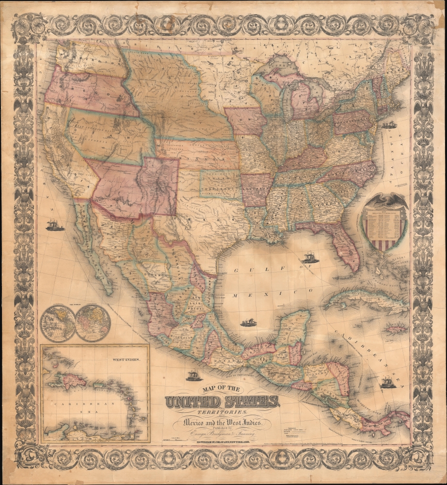
Map of the United States, with its Territories; also Mexico and the West Indies.
1855 (dated) 38.5 x 34.5 in (97.79 x 87.63 cm) 1 : 6336000
1855 (dated) 38.5 x 34.5 in (97.79 x 87.63 cm) 1 : 6336000
Description
A scarce American wall map of the United States and Mexico issued by Ensign, Bridgeman and Fanning in 1856. As the title suggests, the map covers all of the United States as well as Mexico, Cuba, and Central America as far as Panama. Inset maps in the lower left illustrate the world and the Lesser Antilles. The focus of the map is westward expansion in the United States. Updates accordingly focused on administrative changes west of the Mississippi. Here, Texas conforms to the Compromise of 1850 borders, and the Gadsden Purchase has added new territory to New Mexico. The borders of Kansas and Nebraska follow the Kansas-Nebraska Act of May 30, 1854, in which Nebraska stretches to the Canadian border. The gold region in the Sacramento Valley is highlighted in California. The map notes emigrant and exploration routes to the west, including Fremont's Route, the Oregon Trail, and the Santa Fe Caravan route. American Indian lands are rigorously identified throughout as if to remind emigrants that the land is not completely free and uninhabited.
Publication History and Census
This map was first published in 1849 by Horace Thayer and Edward Hooker Ensign, who had it engraved by John M. Atwood. The imprint varied over the years, with the 1851 edition also attributed to 'Ensign and Thayer', an 1853 edition attributed solely to Horace Thayer, and editions from at least 1855 attributed to 'Ensign, Bridgeman, and Fanning', like the present example. The map proved popular due to its more manageable size and was updated annually through at least 1857. While we have not seen another 1856 edition, editions occasionally appear on the market.CartographerS
John M. Atwood (1817 - October 12, 1884) was an American engraver based in Philadelphia and New York City during the middle part of the 19th century. Atwood was born in Georgetown, near Washington D.C. Little is known of Atwood's life but most of his work was completed in conjunction with the publishing firms of Horace Thayer and J. H. Colton. A review of Atwood's work suggests that he was a highly accomplished, stylistically distinct, and detail oriented engraver. Colton seems to have turned to Atwood to engrave some of his most important as well as decorative maps. His most influential map is most likely the 1856 De Cordova pocket map of Texas, however, he also engraved the Colton's well known and highly decorative Thirty Three Miles Around New York and Colton's important 1849 Map of the United States. More by this mapmaker...
Horace Thayer (June 29, 1811 - March 15, 1875) was a New York based publisher and lithographer active in New York City and Buffalo, New York, during the middle part of the 19th century. Thayer's publications focused on travel guides, wall, and pocket maps - many of which were based on the works of other American cartographers including J. H. Colton and S. A. Mitchell. In the 1840s, he partnered with the Hartford, Connecticut publisher Timothy Ensign (1795 - 1849) and later his son, Edward Hooker Ensign (1818 - 1871). According to map historian Walter Ristow, J. H. Colton's older son, George Washington Colton, partnered with Thayer in the late 1850s and early 1860s, possibly in order to learn Thayer's lithography techniques. Certainly a number of maps emerged bearing a 'Thayer and Colton' imprint. At various points Thayer also published with other prominent publishers and printmakers, publishing as Kelloggs and Thayer (1846 - 1847), Ensigns and Thayer (1848), Ensign and Thayer (1849 - 1850), and Ensign, Thayer, and Company (1850 - 1851), Phelps and Watson (1859), and Thayer and Colton (1859-186?). Thayer seems to have moved frequently and had offices at 50 Ann Street, 156 William Street, and at 18 Beekman Street, all in New York City. Learn More...
Edward Hooker Ensign (August 18, 1818 - July 10, 1871) was an American map and print publisher based in New York during the middle part of the 19th century. Edward was born in West Hartland, Connecticut. Little is known of Ensign's training but he may have inherited his business from his father, Timothy Ensign (1795 - 1859), who was a map publisher active in New York. Ensign seems to have had a flair for partnerships and variously published with Humphrey Phelps (1799 - 1875), Horace Thayer, Thomas C. Fanning (1805 - 1873) and Erastus C. Bridgman (1817 - 1870), among others. His various imprints include 'Phelps and Ensign' (1841-1844), 'T. and E. H. Ensign' (1844-1848), 'Ensign and Thayer' (1849), 'Ensign, Thayer, and Company' (1850-1851), 'Horace Thayer and Company' (1852), and 'Ensign, Bridgman and Fanning' (1854-1863). It appears that father and son worked together for some time as well, publishing as either 'T. and E. H. Ensign' or 'Ensigns'. At least some of these companies maintained offices in both Buffalo and New York City. Learn More...
Erastus Clark Bridgman (October 31, 1817 - August 25, 1870) was a New York City based map publisher active in the middle of the 19th century. Bridgman was born in Westhampton, Massachusetts. He was in South Carolina in 1849, where his first child was born, but moved to New York City by 1850. Bridgman was in partnership with Edward H. Ensign (1818 - 1871) and Horace Thayer from 1850 - 1852, publishing under the imprint of 'Ensign, Thayer, and Co.' Later, from 1854 - 1863, the partnership changed to Edward H. Ensign, Thomas C. Fanning (1805 - 1873), and Bridgman, publishing as 'Ensign, Bridgman and Fanning.' After his death, the Bridgman firm was taken over by his son Edward Clark Bridgman (1849 - 19??). Learn More...
Condition
Very good. Restored. Blacked on fresh linen. Clean edging.
References
OCLC 78377921, 883714390.