
This item below is out of stock, but another example (left) is available. To view the available item, click "Details."
Details
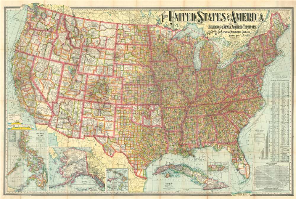
1902 National Publishing Map of the United States and Territories
1901 (dated) $550.00
1902 National Publishing Map of the United States and its Territories
UnitedStates-nationalpublishing-1902-2$275.00

Title
The United States of America Including All Its Newly Acquired Territory.
1902 (dated) 37 x 56 in (93.98 x 142.24 cm) 1 : 3294720
1902 (dated) 37 x 56 in (93.98 x 142.24 cm) 1 : 3294720
Description
This is a 1902 National Publishing Company map of the United States with a typographically elaborate title. The map depicts the continental United States from the Pacific Ocean to the Atlantic Ocean and the Bahamas and from Canada to Mexico and the Gulf of Mexico. Each of the states and territories are divided into counties, with myriad cities, towns, and villages labeled. The distinction between the developing western states, with enormous scarcely populated counties and the eastern states is made stark by the map's rich coloring. The road network spreads across the country like a web, with major cities functioning as hubs. Shipping lanes are noted in the Atlantic and Pacific, with their destination and the company which operates on that route provided. Several inset maps are situated along the lower border, including Puerto Rico, Cuba, Hawaii, Wake Island, Guam, Samoa, Tutuila Island, Howland Island and Baker Island, Alaska (with a smaller inset of the western portion of the Aleutian Islands), and the Philippines.
Publication History and Census
This map was published by The National Publishing Company of Boston, Massachusetts, in 1902. It was first issued in 1901, the present example being the second edition. In the year this map was issued, the National Publishing Company merged with its sister company, the Scarborough Company. The Scarborough Company subsequently split this large map into separately published eastern and western sheets.Cartographer
National Publishing Company (1897 - 1902) was an American map publishing firm founded in Portland, Maine in 1897. The founders, brothers Walter C. Scarborough (June 4, 1862 - May 9, 1904) and Howard G. Scarborough (December 23, 1867 - June 10, 1905), were also proprietors of the Scarborough Company and the Dominion Publishing Company. The National Publishing Company was intended to be managed by Howard, with Walter serving as treasurer. By 1901, the firm had relocated to Boston, where it published and sold large scale brilliantly printed road maps. In 1902, the Scarborough brothers merged their three concerns into the Boston based Scarborough Company and opened an office in Indianapolis, Indiana. Walter and Howard died in 1904 and 1905, both from tuberculous, but the Scarborough Company continued, transferring its offices to Indianapolis. In 1913 it became the Scarborough Motor Guide Company (c. 1913 - c. 1933). It does not appear to be related to the more prominent general publisher of the same name based out of Philadelphia. More by this mapmaker...
Condition
Very good. Wear along original fold lines, especially at old fold intersections, where in places there is archival verso reinforcement. Attached to original boards.
References
OCLC 24424003.