
1860 Colton / Phelps and Watson Wall Map of the United States, Eve of the Civil War

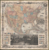

Phelps and Watson's New Map of the United States.
Ephemeral Territories in the American West.
- Digital Map Information
- Suitable for large format printing
- Full resolution TIFF file
- ICC color profile embedded
- Delivered instantly via download link
Ephemeral Territories in the American West.
This is a rare 1860 wall map of the United States published by Phelps and Watson. It presents the territorial configuration of U.S. states and territories on the eve of the U.S. Civil War (1861 - 1865), which would drastically reshape the map.A Closer Look
This sheet consists of two main parts: a map which occupies the top two-thirds of the sheet and a series of illustrations in the bottom third. The map depicts the Continental United States and much of Mexico, along with a portion of Canada, recording states and territories, mountains, waterways, settlements, and infrastructure. It is notable for including large and ephemeral western territories (discussed below), as well as other transient or incomplete elements of the American West.The routes of planned and proposed railroads are traced in bold red lines, while the Pony Express Route and southern Overland Mail Route are traced in blue. Also traced but not colored are routes of military officers and early American explorers of the West, including Fremont, Stansbury, and Mullan. Forts, mountain passes, post offices, and mining settlements are recorded throughout the American West, as well as mention of some of the larger Indian nations (in all caps), a reflection of their ongoing displacement. In the eastern United States, the density of railways and canals reflects the growing interconnection and infrastructural development in those states.
An elaborate and distinctive decorative border surrounds the map, interspersed with scenes representing regions of the newly transcontinental nation. Among them is a proposed but never-built Washington Monument intended for Hamilton Square, a planned public space in today's Lenox Hill between Third and Fifth Avenues and 66th and 69th Streets. Although its cornerstone was laid in 1847, funding shortages and disputes over the design prevented construction. The city later repurposed the site, partly for the Normal College, now Hunter College.
The illustration of the Capitol Building in Washington, D.C., at bottom-right, is also noteworthy. The dome was under construction at the time of publication (it was mostly completed in 1863 and finally completed in 1866), and its design had to be modified several times after construction had begun, which is why the illustration here looks unusual. The bottom border also includes depictions of cattle wrangling in Mexico and Mexico City's Metropolitan Cathedral, emphasizing the extensive coverage of Mexico in addition to the U.S.
The bottom portion of the sheet also includes the seals of the individual U.S. states and territories. The large engraving representing the signing of the Declaration of Independence was done by (Benson J.) Lossing and (William) Barritt and is based on John Trumbull's famous 1817 painting of the same. A smaller 'key' with portraits of the signers of the Declaration and facsimiles of their signatures is also based on an early 19th-century Trumbull work.
Historical Context
In the tense years leading up to the U.S. Civil War, the territorial landscape of the American West was fluid and rapidly changing due to increased settlement and tensions over slavery. A massive Nebraska Territory, established in 1854, stretched from the 40th parallel north to the Canadian border, encompassing present-day Nebraska along with portions of North and South Dakota, Wyoming, Montana, and northeastern Colorado. To its east is the unofficial territory of Dakota, the unorganized territory that was left over when Minnesota became a state in 1858, taking in lands east of the Red River. Further west, when Oregon attained statehood in 1859, its unincluded eastern lands were absorbed into an expanded Washington Territory covering much of today's Idaho along with portions of western Montana and Wyoming. Meanwhile, the Southwest saw short-lived, ephemeral arrangements that reflected both regional settlement patterns and pre-war geopolitics, including a large Utah Territory containing today's Utah, Nevada, and much of Colorado.By the end of the U.S. Civil War, the map of the West would look completely different, with the Dakota Territory (1861), Idaho Territory (1863), and Montana Territory (1864) reducing the huge Nebraska Territory and enlarged Washington Territories. The Colorado and Nevada Territories (both 1861) likewise cut down the large Utah Territory to something like its present size and shape (Nevada's eastern border was shifted one degree of longitude eastwards in 1866 to include newly discovered gold deposits).
'Horizontal' Arizona
Undoubtedly the most unusual feature of this map is the 'horizontal' configuration of the Arizona and New Mexico Territories. Following the Gadsden Purchase, the New Mexico Territory spanned the entire expanse between Texas and California. With only a small population and minimal political influence, the southern region of the territory was largely ignored by the New Mexico territorial government in Santa Fe. Disaffected citizens in the south held conventions throughout 1860. They applied several times to be granted independent territorial status for an east-west strip of land lying south of the 34th parallel called Arizona (sometimes as 'Arrizona'). However, its low population caused the request to be repeatedly denied.At the outbreak of the Civil War, the southern 'Arizonans' recognized an opportunity to appeal to an alternate body for the region's political needs and threw in their lot with the secessionist southern states. Around this time, the Union began to withdraw troops from the region due to fears that Santa Fe would be attacked by Confederate soldiers operating out of Texas. In Texas itself, the Confederate Colonel John Robert Baylor, recognizing a strategic opportunity, led his troops into Southern Arizona and won some early victories against Union troops. Shortly thereafter, Baylor declared himself Territorial Governor of the Confederate Territory of Arizona. However, the Union side regrouped and counterattacked, and the Confederate Territory of Arizona ultimately lasted less than a year. It was seized by the Union Army and dismantled in favor of the current configuration, with the Arizona-New Mexico border situated along a north-south axis. This longitudinal border allowed both territories to be enriched by the proposed Southern Pacific Railroad route seen here, which otherwise might have only passed through Arizona. This is one of the few maps issued during this short and politically volatile period to specifically depict the 'horizontal' Territory of Arizona.
Publication History and Census
The map portion of the sheet was prepared by the stalwart Colton firm, then managed by George Woolworth Colton, son of founder Joseph Hutchins Colton. The map was engraved by John M. Atwood, with the border drawn and engraved by W. S. Barnard. The entire sheet was printed by Lang and Liang and published by Phelps and Watson in New York in 1860. It is the descendant of earlier wall maps issued by complex configurations of New York City publishers including Phelps, Fanning, Bridgeman, and Ensign (see, for comparison, our UnitedStates-ensignbridgemanfanning-1855). However, the present map is quite rare, only being cataloged at the University of Southern Maine's Osher Map Library, while the Boston Public Library holds an 1861 edition.Cartographers
Humphrey Phelps (1799 - 1875) was an American map, broadside, and book publisher based in New York City. Phelps was born in 1799 in Hebron, Connecticut. Phelps' earliest work seems to be a plan of New York City for his Stranger's Guide, dating to about 1830. Between 183- and 1837 he published with Bela Scovil Squire (1786 - 1861) under the imprint of Phelps and Squire. The New York map publishing circle seems to have been quite close and Phelps commonly partnered with various other New York publishers and printers including Edward H. Ensign (1818 - 1871), Horace Thayer, Erastus Clark Bridgman (1817 - 1870), Thomas C. Fanning (1805 - 1873), Hooker, Peabody, Charles Magnus, Gaylord Watson, and George Walker, among others. The natural consequence of his rampant partnering is a vast and varied corpus of work including many scarce items with low print runs. Phelps is best known for his emigrant and tourist guides. Further Details...
Gaylord Watson (September 23, 1833 - October 10, 1896) was an American map publisher and engraver based in New York City. Watson briefly partnered with his uncle Humphrey Phelps as Phelps and Watson (1859 - January 1, 1865) with offices at 16 Beekman Street, New York. After 1864 he established his own imprint, now at 61 Beekman. Watson focused on highly decorative emigrant guides, wall maps, and railroad maps. Around 1871 Watson established a branch office in Chicago under the management of D. Needham at no. 66 Lake Street. In 1881 a fire destroyed Watson's offices at 61 Beekman Street, pushing him into deep financial stress. A notice appearing in Publisher's Weekly, 1893, reads, 'Gaylord Watson, map publisher, has been sold out by the sheriff. The sale realized about $800', suggesting that Watson had either died or fallen into bankruptcy. Watson lived in Queens, then Brooklyn, and in 1894, shortly before his death, Omaha, Nebraska. Further Details...
Joseph Hutchins Colton (July 5, 1800 - July 29, 1893), often publishing as J. H. Colton, was an important American map and atlas publisher active from 1833 to 1897. Colton's firm arose from humble beginnings when he moved to New York in 1831 and befriended the established engraver, Samuel Stiles. He worked under Stiles as the 'Co.' in Stiles and Co. from 1833 to 1836. Colton quickly recognized an emerging market in railroad maps and immigrant guides. Not a cartographer or engraver himself, Colton's initial business practice mostly involved purchasing the copyrights of other cartographers, most notably David H. Burr, and reissuing them with updated engraving and border work. His first maps, produced in 1833, were based on earlier Burr maps and depicted New York State and New York City. Between 1833 and 1855, Colton proceeded to publish a large corpus of guidebooks and railroad maps, which proved popular. In the early 1850s, Colton brought his two sons, George Woolworth Colton (1827 - 1901) and Charles B. Colton (1832 - 1916), into the map business. G. W. Colton, trained as a cartographer and engraver, was particularly inspired by the idea of creating a large and detailed world atlas to compete with established European firms for the U.S. market. In 1855, G.W. Colton issued volume one of the impressive two-volume Colton's Atlas of the World. Volume two followed a year later. Possibly because of the expense of purchasing a two-volume atlas set, the sales of the Atlas of the World did not meet Colton's expectations, and so, in 1856, the firm also issued the atlas as a single volume. The maps contained in this superb work were all original engravings, and most bear an 1855 copyright. All of the maps were surrounded by an attractive spiral motif border that would become a hallmark of Colton's atlas maps well into the 1880s. In 1857, the slightly smaller Colton's General Atlas replaced the Atlas of the World. Most early editions of the General Atlas published from 1857 to 1859 do not have the trademark Colton spiral border, which was removed to allow the maps to fit into a smaller format volume. Their customers must have missed the border because it was reinstated in 1860 and remained in all subsequent publications of the atlas. There were also darker times ahead; in 1858, Colton was commissioned at a sum of 25,000 USD by the government of Bolivia to produce and deliver 10,000 copies of a large format map of that country. Although Colton completed the contract in good faith, delivering the maps at his own expense, he was never paid by Bolivia, which was at the time in the midst of a series of national revolutions. Colton would spend the remainder of his days fighting with the Bolivian and Peruvian governments over this payment, and in the end, after a congressional intervention, he received as much as 100,000 USD in compensation. Nonetheless, at the time, it was a disastrous blow. J. H. Colton and Company is listed as one of New York's failed companies in the postal record of 1859. This led Colton into the arms of Alvin Jewett Johnson and Ross C. Browning. The 1859 edition of Colton's General Atlas lists Johnson and Browning as the 'Successor's to J. H. Colton' suggesting an outright buyout, but given that both companies continued to publish separately, the reality is likely more complex. Whatever the case may have been, this arrangement gave Johnson and Browning access to many of Colton's map plates and gave birth to Johnson's New Illustrated (Steel Plate) Family Atlas. The Johnson's Atlas was published parallel to Colton's atlases well into the 1880s. The Colton firm itself subsequently published several other atlases including an Atlas of America, the Illustrated Cabinet Atlas, the Octavo Atlas of the Union, and Colton's Quarto Atlas of the World. They also published a large corpus of wall maps, pocket maps, and guides. The last known publications of the Colton firm date to 1897 and include a map and a view, both issued in association with the Merchant's Association of New York. Alice M. Colton married August R. Ohman (May 3, 1859 - April 22, 1934) on January 5, 1897. In 1898, Ohman joined the Colton firm, which continued to publish as Colton, Ohman & Co. until 1901. Further Details...
Lang and Laing (fl. 1861 – August 16, 1862) were New York City based publishers and lithographers active in the middle part of the 19th century. The firm was founded by founded by William Lang and Joseph Laing and maintained offices at 117 Fulton Street, New York City. They specialized in transferring copper and steel plates to lithographic stone for more economical printing. Their most significant cartographic work is the Jacob de Cordova and Robert Creuzbaur map of Texas. The firm was dissolved in August of 1862. Lang went on to partered with Henry Pooley Cooper, and continued to publish under the Lang and Cooper imprint until 1864. Further Details...
John M. Atwood (1817 - October 12, 1884) was an American engraver based in Philadelphia and New York City during the middle part of the 19th century. Atwood was born in Georgetown, near Washington D.C. Little is known of Atwood's life but most of his work was completed in conjunction with the publishing firms of Horace Thayer and J. H. Colton. A review of Atwood's work suggests that he was a highly accomplished, stylistically distinct, and detail oriented engraver. Colton seems to have turned to Atwood to engrave some of his most important as well as decorative maps. His most influential map is most likely the 1856 De Cordova pocket map of Texas, however, he also engraved the Colton's well known and highly decorative Thirty Three Miles Around New York and Colton's important 1849 Map of the United States. Further Details...
Condition
Very good. Full professional restoration. Mounted on fresh linen. Areas of loss and infill.
References
Boston Public Library, Leventhal Map and Education Center G3700 1861.C65x (1861 ed.).