This item has been sold, but you can get on the Waitlist to be notified if another example becomes available, or purchase a digital scan.
1792 Purcell Map of the United States w/ State of Franklinia
UnitedStates-purcell-1792$850.00

Title
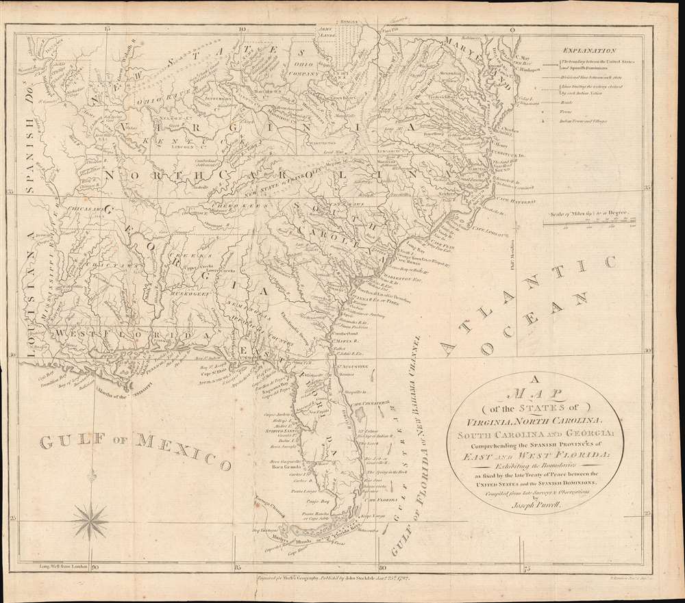
A Map of the States of Virginia, North Carolina, South Carolina and Georgia; Comprehending the Spanish Provinces of East and West Florida: Exhibiting the Boundaries as fixed by the late Treaty of Peace between the United States and the Spanish Dominions.
1792 (dated) 13 x 15 in (33.02 x 38.1 cm) 1 : 6000000
1792 (dated) 13 x 15 in (33.02 x 38.1 cm) 1 : 6000000
Description
This 1792 Joseph Purcell map of the United States recording post-Revolutionary War westward expansion. This is one of the earliest maps to identify the ephemeral pseudo-state of Franklinia, the claims of the Ohio Company of Associates, the lands of the New Jersey and Wabash Companies, the Cumberland Settlement, and the Moravian Settlement. It is moreover, one of the best maps of the American Indian nations in the southeast - benefiting from Purcell's firsthand reconnaissance. Significantly, this is also the first maps of the United States by a southern cartographer.
As an aside, the Ohio Company presented here was the second organization known by that name, the first being an English-Virginian company operating from roughly 1748 - 1776. Those lands were generally to the south of the Ohio River.
The State of Franklin
The map's most intriguing aspect is its inclusion of the State of Franklin. Also known as the Frankland or Franklinia, Franklin was a pseudo-state named after Benjamin Franklin and founded by settlers in what was then western North Carolina. It is unique in that it originated in both a cession and secession. Franklin emerged from land in western North Carolina ceded to the federal government to pay war debts. The region was remote, and settlers rightly complained that their interests were sidelined by both North Carolina and the federal government. In hope of greater representation, the Franklinites, as they became known, seceded from North Carolina in 1784 and applied for independent statehood. Despite two attempts with Congress, Franklin was never recognized. For a time, still at odds with North Carolina over taxation, protection, and other issues, Franklin began operating as a de facto independent republic. After four years of turmoil, indecision, increasing debt, and dismissal by Congress, the area was reabsorbed by North Carolina in 1788. Shortly thereafter it become a part of Tennessee, which itself became a state in 1796.First Nations Mapped
The map benefits from Purcell's years of experience mapping American Indian lands in what is today Georgia and Alabama. It offers a wealth of American Indian information relating to the Cherokee, Chickasaw, Choctaw, Creek, Muscogee, and Seminole, particularly in the western parts of Georgia. In Florida this is one of the few maps to name the Upper Creek settlement of New Eufaula, in central Florida, established in 1767 by Creek refugees from Eufaula, a major Creek settlement located in what is today Alabama.The Ohio Company of Associates
This is one of the few maps to illustrate the claims of the Ohio Company of Associates, commonly known as the Ohio Company. The Ohio Company of Associates (OCA) represented here was a Post-Revolutionary War (1775 - 1783) organization founded in 1786 by a cadre of American land-speculators. OCA land claims were exclusively north of the Ohio River, consisting of lands Congress intended to incorporate into the Northwest Ordnance. The OCA's goals were to foster the sale and settlement of most of modern-day Ohio, but initially focused on the north bank of the Ohio River, as here. To this end, the company acquired vast tracts of land from Congress and immediately set to promoting the region. They founded the city of Marietta, and began developing homesteads and trade networks throughout the region. Conflicts with American Indian tribes began almost immediately, leading to the Northwest Indian War (1786 - 1795) and the Big Bottom Massacre (1791). To avoid further conflict, the Federal Government donated an additional 100,000 acres to the north of the initial purchase to act as a buffer zone. Ultimately, the OCA was unable to make its second payment to Congress, and thus forfeited nearly half of their initial claim. Other land companies and settlement schemes followed, including the Connecticut Reserve, the Seven Ranges, and the Scioto Company.As an aside, the Ohio Company presented here was the second organization known by that name, the first being an English-Virginian company operating from roughly 1748 - 1776. Those lands were generally to the south of the Ohio River.
New Jersey and Wabash Companies
The New Jersey and Wabash Companies were private joint stock ventures predating the American Revolutionary War that were formed to purchase and settle American Indian lands. Despite collecting considerable investment and purchasing vast tracts of territory both companies were based upon an illegal premise. Before the Revolution, the Royal Proclamation of 1763 forbade private purchase of Native American lands, so Great Britain refused to recognize these transactions. Following the outbreak of the American Revolutionary War, officials of the merged Illinois-Wabash Company appealed to both Virginia (which claimed the Illinois Country) and to the United States to recognize their land purchases, but were unsuccessful. After the United States bought the land in question from Native Americans and resold it, the matter eventually went to the Supreme Court of the United States. In Johnson v. M'Intosh (1823), the Court ruled that the U.S. government, following earlier British precedent, would not recognize private purchases of native lands, and that New Jersey and Wabash Company's purchases were therefore invalid.The Cumberland Settlements
It what is today western Tennessee, northeast of Nashville, Purcell notes the Cumberland Settlements. The Cumberland Settlements consisted of a vast tract of land between the Kentucky and Cumberland rivers from the Cherokee in March of 1775 by the Transylvania Company in what became known as the Transylvania Purchase. Some 256 pioneering settlers moved into the area and, in 1780, drafted the Cumberland Compact. The compact, which survives in a single example, was a founding document that later contributed to the Tennessee Constitution.Publication History and Census
This map was drawn by Joseph Purcell and engraved by John Stockdale in Ireland for Jedediah Morse's American Universal Geography. There are three editions, this being the second. The first bears a 1788 Amos Doolittle of New Haven imprint and appeared in both American Universal Geography and the August 1788 edition of the American Magazine. The second, as here, bears the 'John Stockdale Jan. 25th, 1792' imprint. Stockdale was a superior engraver and had access to better paper and printing tools, making the second edition far more visually appealing. We are aware of an unattributed 3rd edition possibly published in New York.CartographerS
Joseph Purcell (1750 - 1807) was an Irish-American surveyor active in South Carolina in the late 18th and early 19th centuries. He emigrated to the United States around 1765 when he was 15 years old to apprentice under William Gerard De Brahm (1718 - 1799). His earliest work under De Brahm's tutelage include manuscript maps of Georgia and Florida. Completing his apprenticeship, Purcell took a position in Charleston under John Stuart (1718 - 1779), who headed the southern district of the British Indian Department. Under Stuart, Purcell completed a multi-sheet manuscript map illustrating south-eastern American Indian Lands - the so-called Stuart-Purcell map. Despite being an active surveyor, only one of Purcell's maps was ever printed, a post-Revolutionary war map of the southern United States compiled for Jedediah Morse's American Universal Geography. Most of his other work consisted of legal surveys, many of which survive, but none of which were published. There is some indication that he became involved in the slave trade. He will, written in March of 1806, was composed while. He was about to undertake a dangerous voyage on the Congo River. A prescient choice, as he died there in 1807. Back in Charleston, his substantial estate was auctioned, including 'one sextant, one level, and a complete set of surveyor’s instruments'. More by this mapmaker...
John Stockdale (March 25, 1750 - June 21, 1814) was an English book and map publisher active in London in the late 18th and early 19th centuries. Stockdale, born in Caldbeck, England, was trained by his father in the family trade of blacksmithing. Blacksmithing must not have been his cup of tea, for as soon as he was able, he left this trade in favor of a number of minor service positions, working at various times as a porter and a valet. One such position put him in the service of the bookseller John Almon. Having learnt the book trade by observing Almon, Stockdale opened his own bookshop and began publishing various historic and scientific works. Fellow publishers, perhaps reacting to his social status at birth, wrote of him, "being a man of natural parts, he soon became conspicuous in business in spite of much eccentricity of conduct and great coarseness of manners." Never quite accepted in the trade, Stockdale's fellow London publishers derogatorily referred to him as "The Bookselling Blacksmith". Nonetheless, Stockdale had a number of important works to his name, including several geographies, most notably the 1794American Geography 1794 and, with John Cary, the 1805 New British Atlas. Learn More...
Jedidiah Morse (August 23, 1761 – June 9, 1826) was an American geographer and minister active in Connecticut during the late 18th and early 19th centuries. Morse wan born in Woodstock, Connecticut and studied at Yale University, earning a M. A. in 1786. He advocated for better education for young women and founded a school to this end in New Haven in 1783. Morse was active in religious circles and often railed against the 'assaults of Unitarianism.' Nonetheless, it was as an advocate for women's education that Morse contributed the most to cartography. Recognizing a need for better textbooks, he published a series of geographies including Geography Made Easy (1784), American Geography (1789), and the Universal Geography of the United States (1797). His work with geographical textbooks earned him the informal title 'Father of American Geography.' He married Elizabeth Ann Finley Breese sometime after 1789, when he became a pastor in Charlestown, Boston, with whom he had several children. His eldest son, Samuel Finley Breese Morse (April 27, 1791 – April 2, 1872), was a noted painter and telegraphy pioneer (also a co-developer of Morse code). Some of his other children were Sidney Edwards Morse (February 7, 1794 - December 24, 1871), a noted geographer and inventor, and Richard Cary Morse (1795 - 1868), who helped his father with his geographical work and founded the New York Observer with his brother Sidney. Learn More...
Source
Morse, J., The American Geography; Or, A View of the Present Situation of the United States of America, ( London: John Stockdale) 1794.
Condition
Very good. Slight wear on old fold lines.
References
OCLC 51847142. Rumsey 0632.014. Baynton-Williams (TMC-72) p. 15, #4. Sellers, John R. and Van Ee, Patricia, Maps and Charts of North America, #1410. Wheat, J.C., and Brun, C. F., Maps and Charts Published in America before 1800; a Bibliography, #491. Sabin, J., A Dictionary of Books Relating to America: from its Discovery to the Present Time, 50924. Wooldridge, W., Mapping Virginia: From the Age of Exploration to the Civil War, #145.