This item has been sold, but you can get on the Waitlist to be notified if another example becomes available, or purchase a digital scan.
1819 Thomson Map of the United States [Franklinia]
UnitedStates-thomson-1819-2$500.00

Title
United States.
1819 (undated) 12.25 x 9.75 in (31.115 x 24.765 cm) 1 : 9500000
1819 (undated) 12.25 x 9.75 in (31.115 x 24.765 cm) 1 : 9500000
Description
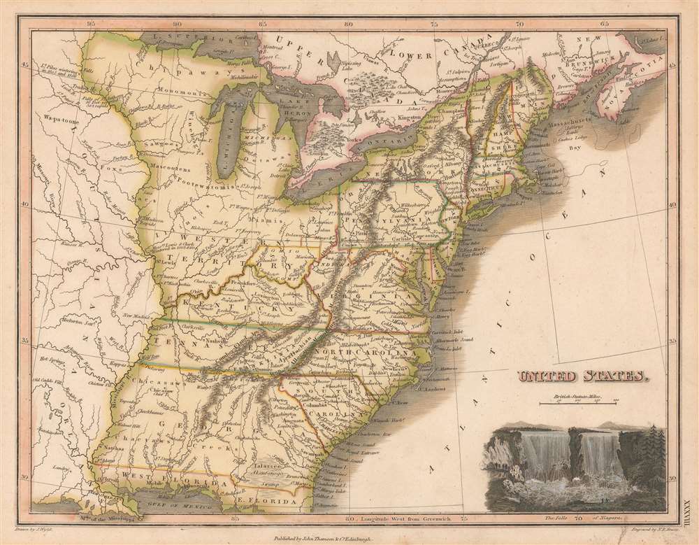
This 1819 Thomson / Wyld map of the United States, one of the last and few maps to identify the ephemeral pseudo-state of Franklinia, as well as the land claims of the Ohio Company of Associates. Coverage extends from the Missouri River to the Atlantic and from the Great Lakes to the Gulf of Mexico. A vignette view of the Niagara Falls sets in the lower right.
As an aside, the Ohio Company presented here was the second organization known by that name, the first being an English-Virginian company operating from roughly 1748 - 1776. Those lands were generally to the south of the Ohio River.
The State of Franklin
The map's most intriguing aspect is its inclusion of the State of Franklin. Also known as the Frankland or Franklinia, Franklin was a pseudo-state named after Benjamin Franklin and founded by settlers in what was then western North Carolina. It is unique in that it originated in both a cession and secession. Franklin emerged from land in western North Carolina ceded to the federal government to pay war debts. The region was remote, and settlers rightly complained that their interests were sidelined by both North Carolina and the federal government. In hope of greater representation, the Franklinites, as they became known, seceded from North Carolina in 1784 and applied for independent statehood. Despite two attempts with Congress, Franklin was never recognized. For a time, still at odds with North Carolina over taxation, protection, and other issues, Franklin began operating as a de facto independent republic. After four years of turmoil, indecision, increasing debt, and dismissal by Congress, the area was reabsorbed by North Carolina in 1788. Shortly thereafter it become a part of Tennessee, which itself became a state in 1796.The Ohio Company of Associates
This is one of the few maps to illustrates the claims of the Ohio Company of Associates, commonly known as the Ohio Company. The Ohio Company of Associates (OCA) represented here was a Post-Revolutionary War (1775 - 1783) organization founded in 1786 by a cadre of American land-speculators. OCA land claims were exclusively north of the Ohio River, consisting of lands Congress intended to incorporate into the Northwest Ordnance. The OCA's goals were to foster the sale and settlement of most of modern-day Ohio, but initially focused on the north bank of the Ohio River, as here. To this end, the company acquired vast tracts of land from Congress and immediately set to promoting the region. They founded the city of Marietta, and began developing homesteads and trade networks throughout the region. Conflicts with American Indian tribes began almost immediately, leading to the Northwest Indian War (1786 - 1795) and the Big Bottom Massacre (1791). To avoid further conflict, the Federal Government donated an additional 100,000 acres to the north of the initial purchase (outlined here in orange) to act as a buffer zone. Ultimately, the OCA was unable to make its second payment to Congress, and thus forfeited nearly half of their initial claim. Other land companies and settlement schemes followed, including the Connecticut Reserve, the Seven Ranges, and the Scioto Company.As an aside, the Ohio Company presented here was the second organization known by that name, the first being an English-Virginian company operating from roughly 1748 - 1776. Those lands were generally to the south of the Ohio River.
Publication History and Census
This map was published in the first edition of James Wyld and John Thomson's 1819 General Atlas. It was drawn by James Wyld and engraved by Nathaniel Rogers Hewitt. Well represented institutionally, but scarce to the market.CartographerS
Wyld (1823 - 1893) was a British publishing firm active throughout the 19th century. It was operated by James Wyld I (1790 - 1836) and his son James Wyld II (November 20, 1812 - 1887) were the principles of an English mapmaking dynasty active in London during much of the 19th century. The elder Wyld was a map publisher under William Faden (1749 - 1836) and did considerable work on the Ordinance Survey. On Faden's retirement in 1823, Wyld took over Faden's workshop, acquiring many of his plates. Wyld's work can often be distinguished from his son's maps through his imprint, which he signed as 'Successor to Faden'. Following in his father's footsteps, the younger Wyld joined the Royal Geographical Society in 1830 at the tender age of 18. When his father died in 1836, James Wyld II was prepared to fully take over and expand his father's considerable cartographic enterprise. Like his father and Faden, Wyld II held the title of official Geographer to the Crown, in this case, Queen Victoria. In 1852, he moved operations from William Faden's old office at Charing Cross East (1837 - 1852) to a new, larger space at 475 Strand. Wyld II also chose to remove Faden's name from all of his updated map plates. Wyld II continued to update and republish both his father's work and the work of William Faden well into the late 1880s. One of Wyld's most eccentric and notable achievements is his 1851 construction of a globe 19 meters (60 feet) in diameter in the heart of Leicester Square, London. In the 1840s, Wyld also embarked upon a political career, being elected to parliament in 1847 and again in 1857. He died in 1887 following a prolific and distinguished career. After Wyld II's death, the family business was briefly taken over by James John Cooper Wyld (1844 - 1907), his son, who ran it from 1887 to 1893 before selling the business to Edward Stanford. All three Wylds are notable for producing, in addition to their atlas maps, short-run maps expounding upon important historical events - illustrating history as it was happening - among them are maps related to the California Gold Rush, the New South Wales Gold Rush, the Scramble for Africa, the Oregon Question, and more. More by this mapmaker...
John Thomson (1777 - c. 1841) was a Scottish cartographer, publisher, and bookbinder active in Edinburgh during the early part of the 19th century. Thomson apprenticed under Edinburgh bookbinder Robert Alison. After his apprenticeship, he briefly went into business with Abraham Thomson. Later, the two parted ways, John Thomson segueing into maps and Abraham Thomson taking over the bookbinding portion of the business. Thomson is generally one of the leading publishers in the Edinburgh school of cartography, which flourished from roughly 1800 to 1830. Thomson and his contemporaries (Pinkerton and Cary) redefined European cartography by abandoning typical 18th-century decorative elements such as elaborate title cartouches and fantastic beasts in favor of detail and accuracy. Thomson's principle works include Thomson's New General Atlas, published from 1814 to 1821, the New Classical and Historical Atlas of 1829, and his 1830 Atlas of Scotland. The Atlas of Scotland, a work of groundbreaking detail and dedication, would eventually bankrupt the Thomson firm in 1830, at which time their plates were sequestered by the court. The firm partially recovered in the subsequent year, allowing Thomson to reclaim his printing plates in 1831, but filed again for bankruptcy in 1835, at which time most of his printing plates were sold to A. K. Johnston and Company. There is some suggestion that he continued to work as a bookbinder until 1841. Today, Thomson maps are becoming increasingly rare as they are highly admired for their impressive size, vivid hand coloration, and superb detail. Learn More...
Nathaniel Rogers Hewitt (July 19, 1783 - 1841) was a British engraver active in London during the first half of the 19th century. Hewitt was born in London on the 19th of July 1785. His map engraving work appears as early as 1804, although it is most commonly associated with the 1812 - 1817 atlas maps of publisher John Thomson. Hewitt also worked with James Wyld, Samuel William Fores, and other map publishers of the period. In 1824, Hewitt announced plans to independently publish a series of Parish maps by subscription, and a beautifully engraved map of St. Giles in the Fields followed. The map series must not have been able to attract many followers, as Hewitt declared bankruptcy shortly after in 1826. Learn More...
Source
Wyld, J., A General Atlas, Containing Maps illustrating some important periods in Ancient History; and distinct Maps of the several Empires, Kingdoms and States In The World, (Edinburgh: John Thomson) 1819.
Condition
Very good.
References
Rumsey 2713.060. The Map Collector, 72, Baynton-Williams, A., p.12, map 17.