
This item below is out of stock, but another example (left) is available. To view the available item, click "Details."
Details
1849 Colton Map of United States (Texas at Fullest) (First Edition) (Gold Rush)
1849 (dated) $10,000.00
1855 Colton Wall Map of the United States
UnitedStatesAmr-colton-1855$1,400.00

Title
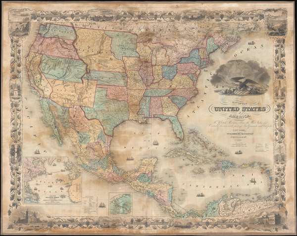
Map of the United States of America, the British Provinces, Mexico, the West Indies, and Central America: with part of New Granada and Venezuela.
1855 (dated) 33 x 40 in (83.82 x 101.6 cm) 1 : 4800000
1855 (dated) 33 x 40 in (83.82 x 101.6 cm) 1 : 4800000
Description
An exceptionally beautiful map of considerable historic importance, this is J. H. Colton's 1855 map of the United States. The map's coverage extends from Canada to Colombia, inclusive of all of the United States, Mexico, Central America, and the West Indies. It is surrounded by an elaborate grape vine themed decorative border engraved by Bernard. The map itself was engraved by Atwood, and is full of fascinating detail relating to the westward migration and early territorial development of the Transmississippi.
An inset has been added to the lower left quadrant detailing the Atlantic Ocean and several trans-Atlantic shipping routes. These include the New York - Boston - Halifax - Liverpool route. Various other routes run from the Havana to Madeira and spider-web throughout the West Indies. No fewer than 15 decorative ships, including both tall ships and steam vessels, decorate the seas. The dramatic cartouche image includes a large Bald Eagle sitting astride a stars and stripes armorial shield and various trade goods. A bustling port scene appears in the background.
The present examples is the 6th edition. The present edition is laid down on linen in wall map format and is accompanied by its original rollers.
Early Territorial Configuration of the Transmississippi
The map is most interesting for its ephemeral delineation of the lands to the west of the Mississippi Valley, where vast new territories acquired at the end of the Mexican American War were rapidly being consolidated into the United States. The publication of this map immediately follows the 1854 Kansas-Nebraska Act, which defined the Kansas Territory and created a new Nebraska Territory extending to border with British America (Canada). Although California, enriched by the 1849 Gold Rush, was already a state, the lands between California and the Rocky Mountains are presented along territorial boundaries. Neither Nevada nor Arizona were yet conceived of. Utah extends from California to Kansas and has its capitol at Fillmore City, although this would soon change to Mormon capital at Salt Lake City. Similarly, Washington and Oregon incorporate vast swaths of land extending form the Pacific to Nebraska.Emigrant Routes
Colton has also notes several routes related to the American Westward Migration. These include the Oregon Trail, with distance notations from Westport Landing, Missouri. The Santa Fe Route, also running from Westport Landing, appears further south. In addition to migrant routes, the map also details military routes, including those taken by General Kearney in 1846, John C. Fremont, and General Wool, among others. Throughout land granted to indigenous American Indian Nations are meticulously noted.An inset has been added to the lower left quadrant detailing the Atlantic Ocean and several trans-Atlantic shipping routes. These include the New York - Boston - Halifax - Liverpool route. Various other routes run from the Havana to Madeira and spider-web throughout the West Indies. No fewer than 15 decorative ships, including both tall ships and steam vessels, decorate the seas. The dramatic cartouche image includes a large Bald Eagle sitting astride a stars and stripes armorial shield and various trade goods. A bustling port scene appears in the background.
Atwood and Barnard's Fine Decorative Engraving
The map is highly decorative and evocative of John M. Atwood's personal style. Although Atwood himself engraved only the map proper, with the border design and pictorial engraving being the work of W. S. Barnard, the whole is so indicative of Atwood's style we can only image that he supervised the full engraving process. The map is surrounded by an elaborate grape vine border with numerous pictorial vignettes. The four primary vignettes illustrate, clockwise from top left: salmon fishing at Willamette Falls, Oregon; the valley of the Connecticut River as seen from Mount Holyoke; the Capitol Building, as yet incomplete, in Washington D.C.; and the cathedral of Mexico City. Lesser vignettes at the top and bottom of the map illustrate John Jacob Astor's fur trading outpost in Astoria, Oregon; Lake Saratoga in New York; Mexican's catching wild cattle; and ships entering a port. To the right and left of the map are illustrations of the Pulaski Monument in Savanna, Georgia; the Battle Monument of Baltimore, Maryland; the Bunker Hill Monument in Boston, Massachusetts; and the Washington Monument in New York City, New York (no longer extant?).Publication History
Colton first issued this map in 1849. Another edition followed later in 1849 in anticipation of the Compromise of 1850 and including updates relating to the explorations of Fremont and the discovery of Gold at Sutter's Mill. Subsequent editions were prepared annually until about 1859.The present examples is the 6th edition. The present edition is laid down on linen in wall map format and is accompanied by its original rollers.
CartographerS
Joseph Hutchins Colton (July 5, 1800 - July 29, 1893), often publishing as J. H. Colton, was an important American map and atlas publisher active from 1833 to 1897. Colton's firm arose from humble beginnings when he moved to New York in 1831 and befriended the established engraver, Samuel Stiles. He worked under Stiles as the 'Co.' in Stiles and Co. from 1833 to 1836. Colton quickly recognized an emerging market in railroad maps and immigrant guides. Not a cartographer or engraver himself, Colton's initial business practice mostly involved purchasing the copyrights of other cartographers, most notably David H. Burr, and reissuing them with updated engraving and border work. His first maps, produced in 1833, were based on earlier Burr maps and depicted New York State and New York City. Between 1833 and 1855, Colton proceeded to publish a large corpus of guidebooks and railroad maps, which proved popular. In the early 1850s, Colton brought his two sons, George Woolworth Colton (1827 - 1901) and Charles B. Colton (1832 - 1916), into the map business. G. W. Colton, trained as a cartographer and engraver, was particularly inspired by the idea of creating a large and detailed world atlas to compete with established European firms for the U.S. market. In 1855, G.W. Colton issued volume one of the impressive two-volume Colton's Atlas of the World. Volume two followed a year later. Possibly because of the expense of purchasing a two-volume atlas set, the sales of the Atlas of the World did not meet Colton's expectations, and so, in 1856, the firm also issued the atlas as a single volume. The maps contained in this superb work were all original engravings, and most bear an 1855 copyright. All of the maps were surrounded by an attractive spiral motif border that would become a hallmark of Colton's atlas maps well into the 1880s. In 1857, the slightly smaller Colton's General Atlas replaced the Atlas of the World. Most early editions of the General Atlas published from 1857 to 1859 do not have the trademark Colton spiral border, which was removed to allow the maps to fit into a smaller format volume. Their customers must have missed the border because it was reinstated in 1860 and remained in all subsequent publications of the atlas. There were also darker times ahead; in 1858, Colton was commissioned at a sum of 25,000 USD by the government of Bolivia to produce and deliver 10,000 copies of a large format map of that country. Although Colton completed the contract in good faith, delivering the maps at his own expense, he was never paid by Bolivia, which was at the time in the midst of a series of national revolutions. Colton would spend the remainder of his days fighting with the Bolivian and Peruvian governments over this payment, and in the end, after a congressional intervention, he received as much as 100,000 USD in compensation. Nonetheless, at the time, it was a disastrous blow. J. H. Colton and Company is listed as one of New York's failed companies in the postal record of 1859. This led Colton into the arms of Alvin Jewett Johnson and Ross C. Browning. The 1859 edition of Colton's General Atlas lists Johnson and Browning as the 'Successor's to J. H. Colton' suggesting an outright buyout, but given that both companies continued to publish separately, the reality is likely more complex. Whatever the case may have been, this arrangement gave Johnson and Browning access to many of Colton's map plates and gave birth to Johnson's New Illustrated (Steel Plate) Family Atlas. The Johnson's Atlas was published parallel to Colton's atlases well into the 1880s. The Colton firm itself subsequently published several other atlases including an Atlas of America, the Illustrated Cabinet Atlas, the Octavo Atlas of the Union, and Colton's Quarto Atlas of the World. They also published a large corpus of wall maps, pocket maps, and guides. The last known publications of the Colton firm date to 1897 and include a map and a view, both issued in association with the Merchant's Association of New York. Alice M. Colton married August R. Ohman (May 3, 1859 - April 22, 1934) on January 5, 1897. In 1898, Ohman joined the Colton firm, which continued to publish as Colton, Ohman & Co. until 1901. More by this mapmaker...
John M. Atwood (1817 - October 12, 1884) was an American engraver based in Philadelphia and New York City during the middle part of the 19th century. Atwood was born in Georgetown, near Washington D.C. Little is known of Atwood's life but most of his work was completed in conjunction with the publishing firms of Horace Thayer and J. H. Colton. A review of Atwood's work suggests that he was a highly accomplished, stylistically distinct, and detail oriented engraver. Colton seems to have turned to Atwood to engrave some of his most important as well as decorative maps. His most influential map is most likely the 1856 De Cordova pocket map of Texas, however, he also engraved the Colton's well known and highly decorative Thirty Three Miles Around New York and Colton's important 1849 Map of the United States. Learn More...
Condition
Good. Full professional restoration. Some offsetting and damage along bottom margin. Stabilized.
References
Rumsey 5535.001 (2nd edition) Boston Public Library, Leventhal Center, G3300 1849 .C65. New York Public Library, Map Div. 01-5133. OCLC : 82726316.