This item has been sold, but you can get on the Waitlist to be notified if another example becomes available, or purchase a digital scan.
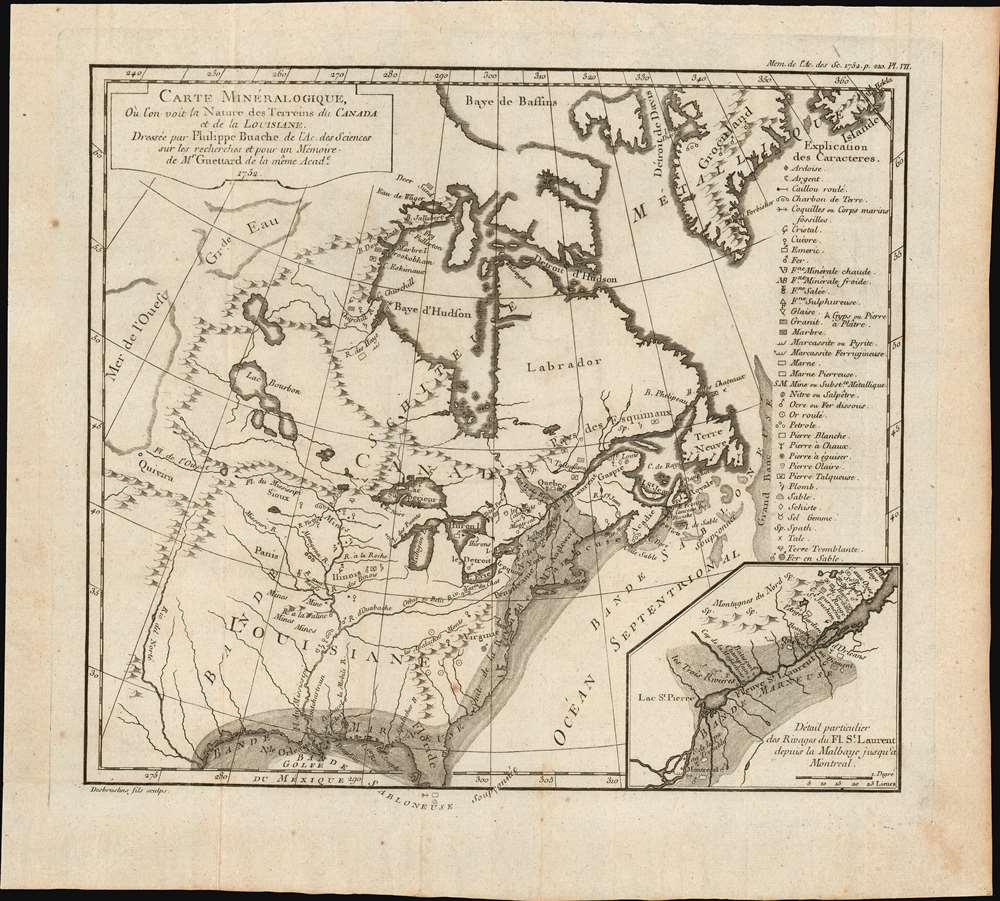
1752 Buache / Guettard 'First' Geological Map of the United States
UnitedStatesGeological-buache-1752$900.00

Title
Carte minéralogique, où l'on voit la Nature des Terreins du Canada et de la Louisiane.
1752 (dated) 11.25 x 12.2 in (28.575 x 30.988 cm) 1 : 15400000
1752 (dated) 11.25 x 12.2 in (28.575 x 30.988 cm) 1 : 15400000
Description
An object of considerable rarity and significance, this is the first geological map of the United States, drawn by Philippe Buache and published in 1752 by Jean-Étienne Guettard. The map covers the eastern part of the modern-day United States and Canada from the Rio del Norte (Rio Grande) and the apocryphal 'Mer de L'Ouest' (Sea of the West) to the Atlantic seaboard, Greenland, and the Grand Banks. The map was part of Guettard's curious presentation issued at the Paris Académie Royale des Sciences comparing the geography of North America to the geography of Switzerland. The report also contained, therefore, the first geological map of Switzerland.
The Sea of the West was a common feature on many mid-18th century pre-Cook French maps. Its earliest appearance was likely on Jean-Baptiste Nolin's 1742 L'Amerique ou le Nouveau Continent. Nolin can only have copied the relevant cartography from an unpublished manuscript globe by the great mapmaker, Guillaume De l'Isle. Then, starting in 1752, J. N. De l'Isle and Philip Buache began presenting the Sea of the West as a monumental bay in conjunction with a viable Northwest Passage. Although De l'Isle and Buache were immediately accused of fraud concerning this geographical feature, the Sea of the West appeared on many maps - some editions even post-dating Cook.
The Geology
Quoting from Mapoteca Geologica Americana,This very curious first Geological Map of a part of North America shows the geographical distribution of three large belts of rocks which Guettard called Bandes sabloueuse marneuse et schisteuse ou métallifère. The marly or clay belt is marked by a shaded zone extending from the shores of Texas on the Gulf of Mexico toward the northeast as far Cape Breton Island, called Isle Royale, then it turns northwest toward Quebec. West of this band lay the schistose or metalliferous belt and east of it the sandy belt under the sea level. Thirty-nine different signs and annotations indicate places where rocks and minerals exist between the Atlantic and the Rocky Mountains. On a smaller map placed at the right-hand lower corner, on a larger scale comprising the shores of the St Lawrence River, Guettard points out eight localities containing fossils. (Mapoteca Geologica Americana: A Catalogue of Geological Maps, Issues 7-14, page 23.)
Sources
By 1752, Guettard was already a well-respected geologist at theAcadémie Royale des Sciences. Working with mapmaker and theorist Philippe Buache, he issued several important geological maps and studies, most focusing on France. He traveled extensively throughout Europe, making mineralogical studies and observing rock formations and strata. Guettard himself never visited the Americas, but at the time much of North America as depicted here, except for a narrow strip of English colonies hugging the Atlantic seaboard, were firmly within French dominion. Guettard particularly relied on extensive correspondence with Jean-François Gaultier (1708 - 1756), the leading naturalist in French North America, as well as a royally appointed physician. He also used data from the journals Pierre François Xavier de Charlevoix (1682 - 1761).The Sea of the West
Buache also includes a magnificent inland sea, called the Sea of the West or, in this case, the Mer de L'Ouest, in the northwestern part of America. This body of water, alternatively called the Sea of the West or Baye de l'Ouest, was speculated by Philippe Buache and Delisle in the early 18th century based upon wishful thinking, American Indian stories, and the somewhat questionable 16th-century explorations of Juan de Fuca. Here, Buache gives the Mer de l'Ouest its fullest expression. Curiously, he specifically does not connect it to either the factual network of lakes and rivers extending westward from the Hudson Bay or to the speculative De Fonte network just to the north.The Sea of the West was a common feature on many mid-18th century pre-Cook French maps. Its earliest appearance was likely on Jean-Baptiste Nolin's 1742 L'Amerique ou le Nouveau Continent. Nolin can only have copied the relevant cartography from an unpublished manuscript globe by the great mapmaker, Guillaume De l'Isle. Then, starting in 1752, J. N. De l'Isle and Philip Buache began presenting the Sea of the West as a monumental bay in conjunction with a viable Northwest Passage. Although De l'Isle and Buache were immediately accused of fraud concerning this geographical feature, the Sea of the West appeared on many maps - some editions even post-dating Cook.
Publication History and Census
This map was drawn by Phillipe Buache at the direction of Jean-Étienne Guettard to illustrate Guettard's Mémoire dans lequel on compare la Canada à la Suisse par rapport à ses Mineraux, published in Histoire de l Académie Royale des Science, 1752. The map appears in multiple institutional collections, but is scarce to the market.CartographerS
Phillipe Buache (February 7, 1700 - January 24, 1773) was a late 18th century French cartographer and map publisher. Buache began his cartographic career as the workshop assistant and apprentice to the important and prolific cartographer Guillaume de L'Isle. Upon De L'Isle's untimely death, Buache took over the publishing firm cementing the relationship by marrying De L'Isle's daughter. Over the years, Bauche republished many of De L'Isle's maps and charts. Buache was eventually appointed Premier Geographe du Roi, a position created-for and previously held by Guillaume de L'Isle. Buache is most respected for his introduction of hachuring as a method from displaying underwater elevation on a two dimensional map surface. Buache compiled maps based upon geographic knowledge, scholarly research, the journals of contemporary explorers and missionaries, and direct astronomical observation. Nevertheless, even in 18th century Paris geographical knowledge was severely limited - especially regarding those unexplored portions of the world, including the poles, the Pacific northwest of America, and the interior of Africa and South America. In these areas the Buache, like his primary rival Robert de Vaugondy, must be considered a speculative geographer or 'positive geographer'. Speculative geography was a genre of mapmaking that evolved in Europe, particularly Paris, in the middle to late 18th century. Cartographers in this genre would fill in unknown areas on their maps with speculations based upon their vast knowledge of cartography, personal geographical theories, and often dubious primary source material gathered by explorers and navigators. This approach, which attempted to use the known to validate the unknown, naturally engendered many rivalries. Buache's feuds with other cartographers, most specifically Didier Robert De Vaugondy, resulted in numerous conflicting papers being presented before the Academie des Sciences, of which both were members. The era of speculatively cartography effectively ended with the late 18th century explorations of Captain Cook, Jean Francois de Galaup de La Perouse, and George Vancouver. Buache was succeeded by his nephew Jean-Nicholas Buache de Neuville. More by this mapmaker...
François Desbruslins (1709 - 17xx) was a French map and line engraver active in Paris during the mid-18th century, from approximately 1719 until 1757. His is known for architectural plans, maps, and scientific diagrams. He engraved numerous maps for several famous French cartographers, including Philippe Buache and Jacques-Nicolas Bellin. Learn More...
Jean-Étienne Guettard (September 22, 1715 - January 7, 1786) was a French mineralogist, naturalist, and geologist active in Paris in the middle to late 18th century. Guettard was born in Étampes, near Paris. His maternal grandfather, François Descurain, an apothecary and doctor based in Étampes, encouraged him in the study of pants and medicines. He later became a medical doctor, but botany and geology remained his primary passion. From 1843, he was a member of the Paris Académie Royale des Sciences to which he submitted his first paper, to great acclaim, in 1746. In 1747, Guettard was offered the position of médecin botaniste to Louis, Duc d’Orléan. The sponsorship continued under the duke's son, Louis-Philippe, and Guettard received housing at the Palais-Royal. He was the first to survey and map the geologic features of France and to study the exposed bedrock of the Paris Basin. He was also produced the first geological maps of the United States (although he never visited) and Switzerland (which he did visit). As a scientist, he avoided making grand theories, instead, focusing on collecting and organizing data. Beyond science, was a devout Jansenist, a Catholic fringe sect that emphasized original sin, human depravity, the necessity of divine grace, and predestination. Guettard died in Paris in 1786. Learn More...
Source
Guettard, J. E., Mémoire dans lequel on compare la Canada à la Suisse. (Paris) 1752.
Condition
Very good. Wide margins. Slight wear on original fold lines.
References
OCLC 494247903.