1817 Thomson Map of the Southeastern United States: Georgia, Carolina, Virginia, Tennessee, Kentucky
UnitedStatesSouthernProvinces-thomson-1817-2$950.00

Title
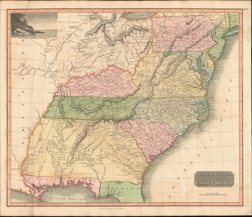
Southern Provinces of the United States.
1817 (dated) 20 x 23.5 in (50.8 x 59.69 cm) 1 : 3000000
1817 (dated) 20 x 23.5 in (50.8 x 59.69 cm) 1 : 3000000
Description
A scarce first edition of John Thomson's 1817 map of the southeastern part of the United States. Thomson prepared this map during a transitional period of expansion shortly following the American Revolutionary War and is among most thorough treatments of this region prior to the U.S. Government Surveys. It records early U.S. efforts to acquire and assimilate American Indian territories west of the Appalachian Mountains.
A Closer Look
The map covers from the Mississippi River eastward to the Atlantic, extending north as far as Lake Erie, and south to northern Florida and the Mississippi River Delta. The states of Pennsylvania, New Jersey, Maryland, Delaware, Virginia, Kentucky, Tennessee, North Carolina, South Carolina, and Georgia are illustrated in full while Ohio, Illinois, Florida, Alabama, and Mississippi have yet to appear as either states or territories. Florida was not yet part of the United States but would join 3 years after this map was printed in 1819. An inset in the upper left corner declares itself typical of the Hudson River and bears a close resemblance to the Palisades just outside New York City.American Indian Lands - Appropriated
This map is particularly interesting for its detailed treatment of American Indian activity between the Mississippi and the Appalachian Mountains. American Indian nations are noted throughout, including the Creek, Seminole, Apache, Choctaw, and Chickasaw, among others. Hunting grounds, villages and fortifications are also identified, sometimes accompanied by the date on which they were destroyed. Thomson additionally identifies the Wabash Company, the Jersey Company and the Illinois Company - joint stock ventures formed during the colonial period to acquire, sell, and colonize American Indian lands. Along these commercial lines, some coal mines are also noted on the Illinois River.Publication History and Census
This is the first edition of Thomson's southeastern United States map from the 1817 edition of the General Atlas. It was engraved by Nathaniel Rogers Hewitt. Though the first edition of Thomson's General Atlas was published in 1814, it did not contain this map, which was initially issued in the 1817 edition. A subsequent edition appeared in 1826.CartographerS
John Thomson (1777 - c. 1841) was a Scottish cartographer, publisher, and bookbinder active in Edinburgh during the early part of the 19th century. Thomson apprenticed under Edinburgh bookbinder Robert Alison. After his apprenticeship, he briefly went into business with Abraham Thomson. Later, the two parted ways, John Thomson segueing into maps and Abraham Thomson taking over the bookbinding portion of the business. Thomson is generally one of the leading publishers in the Edinburgh school of cartography, which flourished from roughly 1800 to 1830. Thomson and his contemporaries (Pinkerton and Cary) redefined European cartography by abandoning typical 18th-century decorative elements such as elaborate title cartouches and fantastic beasts in favor of detail and accuracy. Thomson's principle works include Thomson's New General Atlas, published from 1814 to 1821, the New Classical and Historical Atlas of 1829, and his 1830 Atlas of Scotland. The Atlas of Scotland, a work of groundbreaking detail and dedication, would eventually bankrupt the Thomson firm in 1830, at which time their plates were sequestered by the court. The firm partially recovered in the subsequent year, allowing Thomson to reclaim his printing plates in 1831, but filed again for bankruptcy in 1835, at which time most of his printing plates were sold to A. K. Johnston and Company. There is some suggestion that he continued to work as a bookbinder until 1841. Today, Thomson maps are becoming increasingly rare as they are highly admired for their impressive size, vivid hand coloration, and superb detail. More by this mapmaker...
Nathaniel Rogers Hewitt (July 19, 1783 - 1841) was a British engraver active in London during the first half of the 19th century. Hewitt was born in London on the 19th of July 1785. His map engraving work appears as early as 1804, although it is most commonly associated with the 1812 - 1817 atlas maps of publisher John Thomson. Hewitt also worked with James Wyld, Samuel William Fores, and other map publishers of the period. In 1824, Hewitt announced plans to independently publish a series of Parish maps by subscription, and a beautifully engraved map of St. Giles in the Fields followed. The map series must not have been able to attract many followers, as Hewitt declared bankruptcy shortly after in 1826. Learn More...
Baldwin and Cradock (fl. c. 1810 - 1860) were London based publishers working in the early to mid 19th century. They are best known for their publication of the Society for the Diffusion of Useful Knowledge's ground breaking subscription atlas. They also published John Thomson's magnificent New General Atlas from 1814 - c. 1820. In addition to their cartographic corpus, the firm had wide ranging publishing interests in many other areas, including books, broadsides, and an investment in Blackwoods Magazine. They had their offices at 47 Paternoster Row, London, England. This firm also published under the imprint Baldwin, Cradock, and Joy and Cradock and Joy. Learn More...
Source
Thomson, J., A New General Atlas, (Edinburgh: Baldwin, Craddock, Joy) 1817.
Thomson's New General Atlas was first published in 1817 and continued to be published until about 1821. This is the first of Thomson's major cartographic works and the atlas for which is most celebrated. The New General Atlas follows in the Edinburgh School, which eschews excessive decoration in favor of a more minimalistic fact-based cartographic vision, as established by John Pinkerton, Laurie and Whittle, John Cary, and others in the previous decades. The maps are notable for their massive scale, heavy stock, elegant color work, and easy-to-read typefaces. Although the atlas stopped being published after 1821, Thomson continued to offer 'supplementary' maps that could be tipped into the atlas as late as 1830, when he declared bankruptcy. The maps in the Thomson Atlas were engraved by Thomas Clerk, William Dassauville, Nathaniel Rogers Hewitt, James Kirkwood, Robert Kirkwood, John Menzies, George Menzies, Edward Mitchell, John Moffatt, Samuel John Neele, Robert Scott, and James Wyld.
Condition
Very good. Some offsetting. A couple of minor discolorations.
References
Rumsey 1007.063. Newberry Library: Ayer 135 T4 1817 no. 57. New York Public Library, Map Division, Map Div. 00-373.