This item has been sold, but you can get on the Waitlist to be notified if another example becomes available, or purchase a digital scan.
1812 Tardieu / Lapie Map of the United States
UnitedStatesWestIndies-lapietardieu-1812$4,250.00


Title
A Map of the United States and Canada, New-Scotland, New-Brunswick and New-Foundland. / Carte des Etats-Unis, avec le Canada, La Nouvelle Ecosse, Le Nouveau Brunswick et Terre-Neuve. / A Map of the West-Indies and of the Mexican-Gulph. / Carte des Indies Occidental et du Golfe du Méxique.
1812 (dated) 36 x 31.5 in (91.44 x 80.01 cm) 1 : 6000000
1812 (dated) 36 x 31.5 in (91.44 x 80.01 cm) 1 : 6000000
Description
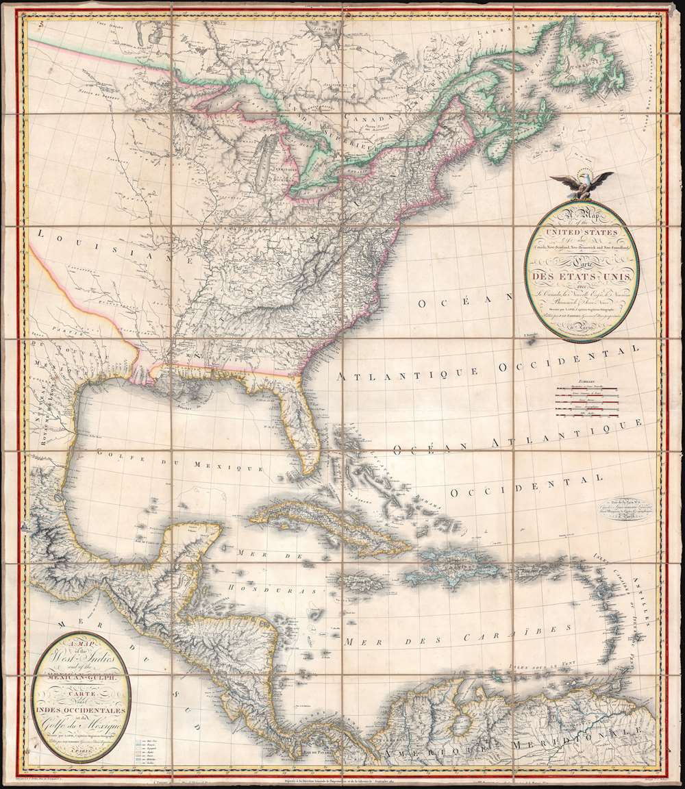
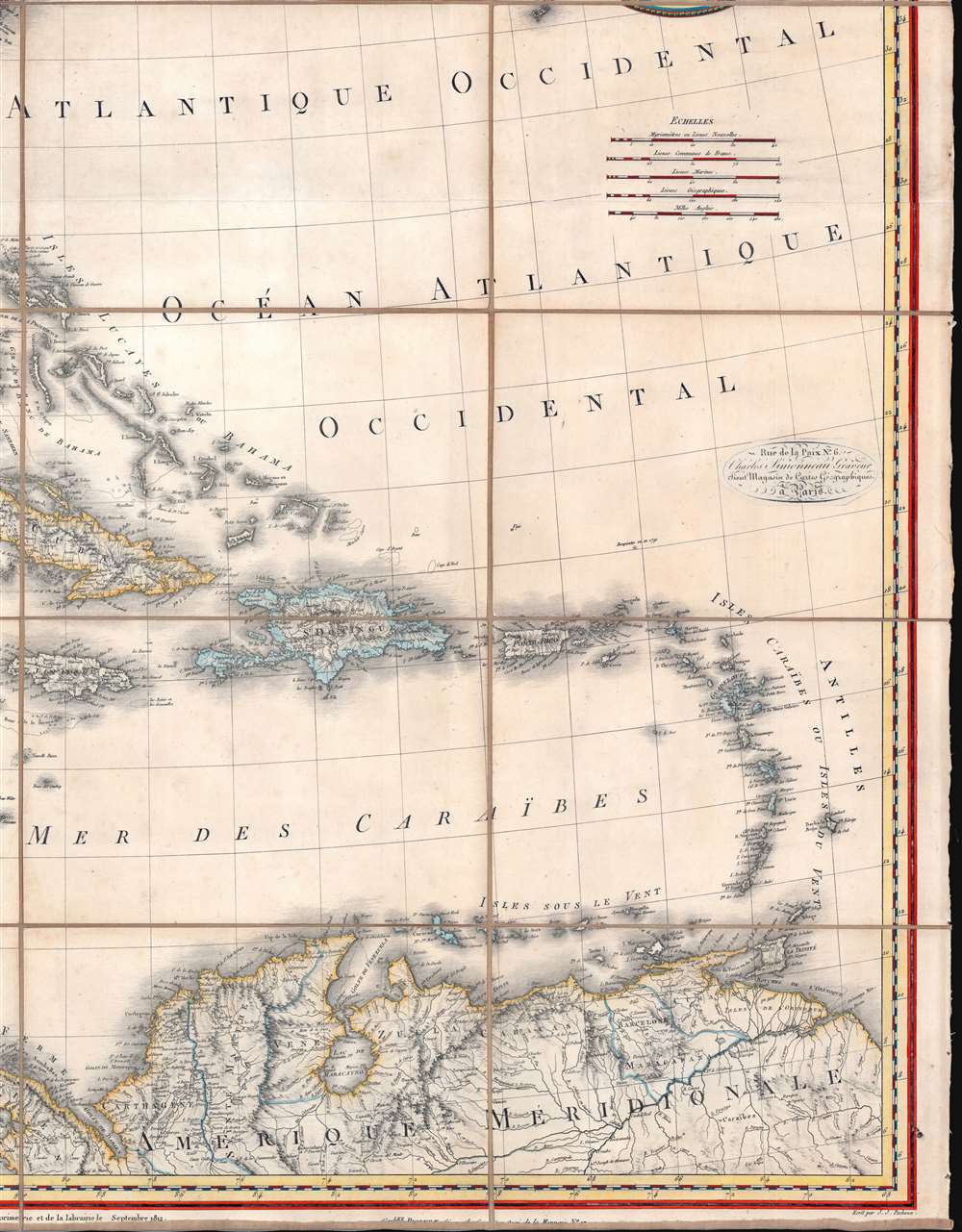
A lavish, large-scale French map of the United States and West Indies issued in September of 1812 - shortly after the outbreak of the War of 1812 (1812 - 1815). This is one of the few major French cartographic productions not focused on Europe to appear during the Napoleonic Wars (1803 - 1815) and needs to be addressed in this context to be fully understood. With titles both in English and French, it calls for brotherhood and alliance against the hated English.
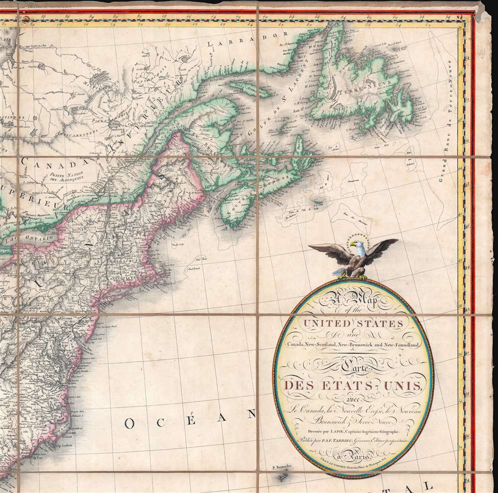
Nonetheless, among the French populace, the outbreak of the War of 1812 was perceived differently - it was a moment that could have ushered a new era of Franco-American alliance. The French had every reason to believe that the many problems souring Franco-American relations - depredations on commerce, imprisonment of sailors, settlement of indemnities, and the lack of a trade agreement - would be resolved. The team of well-respected French cartographers who compiled this map - a lavish optimistic production - titled it in both French and English, underscoring that it was intended for both French and American (certainly not English!) audiences. The map can be seen as a call for alliance and brotherhood.
The hoped-for Franco-American alliance never came to be. Napoleon, distracted by a multi-front war and a growing string of setbacks, ignored American entreaties. By the end of the War of 1812, Napoleon's armies were defeated and the emperor himself exiled to Elba. The newly established Bourbon government was sympathetic to the United States, but after years of war, France was in too weak a position to build mutually-beneficial alliances. Moreover, will all sides declaring victory in the War of 1812, US-British trade relations fully resumed.
This map is scarce - especially, as here, with the West Indies component. We have identified several examples of the 1806 edition, but the OCLC identifies only two libraries holding the 1812, Harvard and the University of Michigan. This edition is also held by several European libraries, including the Universiteitsbibliotheek Utrecht. Due to weak cataloging, it is unclear if these holdings represent the upper portion only, or, as here, both the United States and the West Indies.
A Closer Look
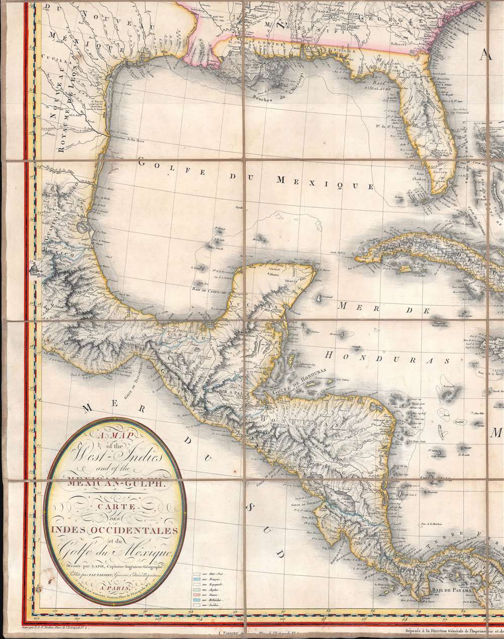
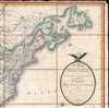
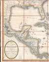
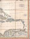
The map covers the United States and West Indies, extending west as far as Texas and Mexico City, and south to include the Gulf of Mexico, Greater and Lesser Antilles, Caribbean Sea, and Spanish Main. The whole has been masterfully engraved by Pierre Antoine-Francois Tardieu. The upper right title cartouche is decorated by an American Bald Eagle.Two Editions
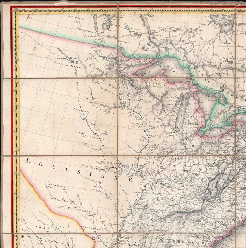
There are two known editions of the map - the present example being the scarcer - both of which correspond to pivotal moments in Franco-American relations. The map first appeared in 1806 - shortly after the Louisiana Purchase during a time when French influence in America was being redefined. The second, present example, was published in September 1812, shortly after the outbreak of the War of 1812. Cartographically, the map of 1812 differs little from the 1806 edition. Despite a wealth of information from the Lewis and Clark Expedition, Louisiana remains largely blank and unexplored. Florida, divided into East and West Florida, is identified as a Spanish possession - according to the Second Spanish Period (1783 - 1819).The French and the War of 1812
When scholars write of the War of 1812, the role of France is often relegated to a footnote at best. At the outbreak of the war, fought between England and the United States, Europe was still enmeshed in the Napoleonic Wars. The powerful English navy had largely locked down French maritime trade. American ships were the only trade vessels granted access to French Ports - providing a vital artery for French goods. This fact was used to justify the British retaliatory practice of 'impressing' American merchant sailors into naval service - the primary impetus for the 1812 declaration of war. Scholarly focus on the French role in the war tends revolve around how the European wars limited England's ability to wage war in the Americas. Or, where France is discussed, the focus is on Napoleon's disinterest in the United States, and the general preference of most Americans, despite being at war, for England.Nonetheless, among the French populace, the outbreak of the War of 1812 was perceived differently - it was a moment that could have ushered a new era of Franco-American alliance. The French had every reason to believe that the many problems souring Franco-American relations - depredations on commerce, imprisonment of sailors, settlement of indemnities, and the lack of a trade agreement - would be resolved. The team of well-respected French cartographers who compiled this map - a lavish optimistic production - titled it in both French and English, underscoring that it was intended for both French and American (certainly not English!) audiences. The map can be seen as a call for alliance and brotherhood.
The hoped-for Franco-American alliance never came to be. Napoleon, distracted by a multi-front war and a growing string of setbacks, ignored American entreaties. By the end of the War of 1812, Napoleon's armies were defeated and the emperor himself exiled to Elba. The newly established Bourbon government was sympathetic to the United States, but after years of war, France was in too weak a position to build mutually-beneficial alliances. Moreover, will all sides declaring victory in the War of 1812, US-British trade relations fully resumed.
Publication History and Census
This map was a lavish production that involved the efforts of four of Paris' most prominent publishers/engravers. These include Pierre Lapie, Pierre Antoine-Francois Tardieu, Charles Picquet, and Jean-Claude Dezauche. The fine lettering was engraved by J. J. Pachoux. Below the right title cartouche a pastedown advertises the geographical and engraving establishment of Charles Simmoneau - likely where this map was initially sold. The map bears two cartouches with separate titles (United States, and West Indies), suggesting it was intended to be issued either in composite form, as here, or separately. Accordingly, the Toronto Public Library holds a version that cuts the map through central Florida with an engraved graduated border, and the Library of Congress owns a southern sheet focusing on the West Indies. There are two known editions of the map, as stated above, 1806 and the present 1812 edition. In 1861, likely in an attempt to capitalize on the American Civil War (1861 - 1865), August Logerot issued another edition of the northern section.This map is scarce - especially, as here, with the West Indies component. We have identified several examples of the 1806 edition, but the OCLC identifies only two libraries holding the 1812, Harvard and the University of Michigan. This edition is also held by several European libraries, including the Universiteitsbibliotheek Utrecht. Due to weak cataloging, it is unclear if these holdings represent the upper portion only, or, as here, both the United States and the West Indies.
CartographerS
Pierre M. Lapie (fl. 1779 - 1850) and his son Alexandre Emile Lapie (fl. 1809 - 1850) were French cartographers and engravers active in the early part of the 19th century. The Lapies were commissioned officers in the French army holding the ranks of Colonel and Capitan, respectively. Alexander enjoyed the title of "First Geographer to the King", and this title appears on several of his atlases. Both father and son were exceptional engravers and fastidious cartographers. Working separately and jointly they published four important atlases, an 1811 Atlas of the French Empire (Alexander), the 1812 Atlas Classique et Universel (Pierre), the Atlas Universel de Geographie Ancienne et Modern (joint issue), and the 1848 Atlas Militaire (Alexander). They also issued many smaller maps and independent issues. All of these are products of exceptional beauty and detail. Despite producing many beautiful maps and atlases, the work of the Lapie family remains largely underappreciated by most modern collectors and map historians. The later 19th century cartographer A. H. Dufour claimed to be a student of Lapie, though it is unclear if he was referring to the father or the son. The work of the Lapie firm, with its precise engraving and informational density, strongly influenced the mid-19th century German commercial map publishers whose maps would eventually dominate the continental market. More by this mapmaker...
Pierre Antoine-François Tardieu (February 17, 1757 - January 14, 1822), also known as Tardieu de l'Estrapade, for his address at Place de L'Estrapade, was a French geographical engraver and publisher active in Paris during the late 18th and early 19th centuries. A member of the large and prolific Tardieu family, which, for over 200 years, produced multiple skilled and active engravers. A disciple of his uncle Pierre-François Tardieu, in his youth Antoine-Francois would sign his works Pierre-François (or P.F. Tardieu; 1711 - 1771) , but later in his career began using his own name or (P.A.F. Tardieu). His two sons, Pierre-Antoine Tardieu and Ambroise Tardieu (1788 - 1841), both became noted geographical engravers in the own right. Learn More...
Charles Picquet (April 15, 1771 – January 15, 1827) was a French cartographer active in Paris during the Napoleonic and post-Napoleonic Eras. Picquet was born in Romagna-sous-Montfaucon, Meuse, France. From about 1798 Picquet supplied maps to the Dépôt de la Guerre. From 1806 he was appointed to Napoleon's Cabinet Topographique. Being politically dexterous, he was able to retain this position after the fall of Napoleon under both Louis XVIII and Charles X. Under Louis XVIII he also obtained the Brevet de Géographe Ordinaire du Cabinet Topographique. He worked with the cartographer Adrien-Hubert Brué on a major atlas project. When Charles Picquet died in 1827, his son, Pierre-Jacques Picquet, continued to publish under his father's imprint name well into the middle part of the 19th century. Learn More...
Jean-Claude Dezauche (1745 - 1824) was a French map publisher active in Paris during the first half of the 19th century. He established his own engraving firm around 1770 after having engraved music since 1762. Dezauche bought the archives of Phillipe Buache and Guillaume de L'Isle from Jean Nicholas Buache, Buache's heir, in 1780. Dezauche soon obtained a monopoly on selling the charts produced by the Dépôt de la Marine. Jean-Claude Dezuache passed his business to his son, Jean André Dezauche, upon his death, who took over selling the Dépôt de la Marine charts. Learn More...
Condition
Very good. Minor damage to upper right and bottom left corners - where the map may have been tacked early in its life. Laid down on old linen. Stable.
References
Rumsey 6754.000. OCLC 58972819.