1865 Hassenstein Map of the White Nile, South Sudan
UpperNile-hassenstein-1865$275.00
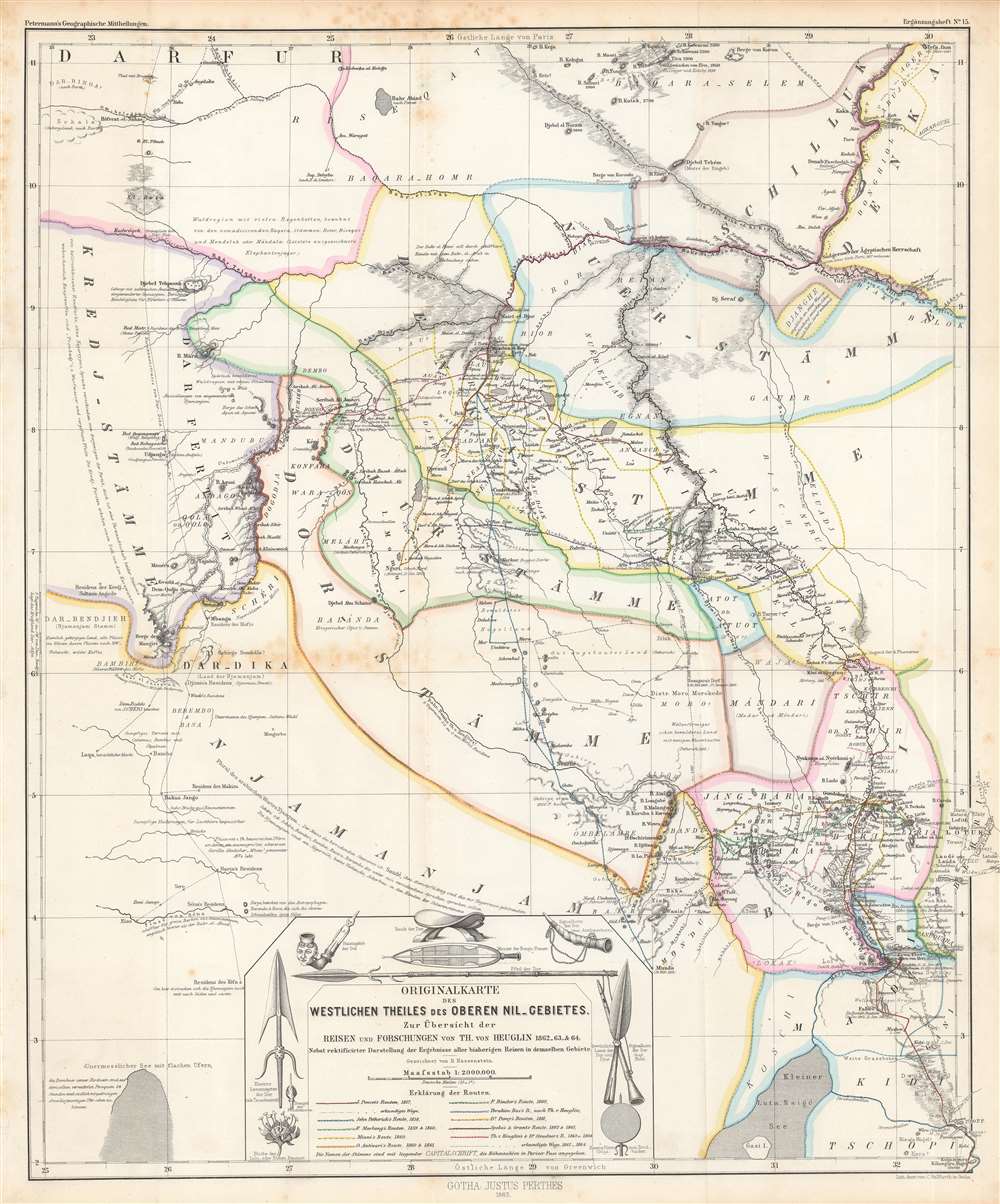

Title
Originalkarte des westlichen Theiles des oberen Nil-Gebietes zur Übersicht der Reisen und Forschungen...
1865 (dated) 21 x 17 in (53.34 x 43.18 cm) 1 : 2000000
1865 (dated) 21 x 17 in (53.34 x 43.18 cm) 1 : 2000000
Description
This is a detailed 1865 Bruno Hassenstein map of the Upper White Nile, concurrent with the eastern part of today's South Sudan. It traces the routes of German and other European explorers of the mid-19th century, including those whose journeys had recently concluded in the months and years prior to publication.
With beautiful hand-coloring, the map illustrates the rough boundaries between different tribes and kingdoms as well as the routes taken by earlier European explorers and administrators, which are noted in the legend. Special attention is given to the recent expedition of Theodor von Heuglin (1824 – 1876). Soon after this map was made, European administrators in the employ of the British-backed Mehmet Ali Dynasty in Egypt, including Charles 'Chinese' Gordon and Emin Pasha, would oversee the region, much of which fell under the province of Equatoria.
Geographic information, especially the all-important waterways, are highlighted. The map utilizes Parisian feet for elevation and uses both Greenwich and Paris as Prime Meridians, while German miles are employed for determining scale. A cartouche includes illustrations of local cultural and military items as well as flora.
A Closer Look
This map covers an area that today includes the eastern part of South Sudan into northern Uganda, along the White Nile. Two major river systems dominate the map, the Bahr al Jabal (Bahr-el-Djebel) and the Bahr el Ghazal (Bahr-el-Ghasal), which meet at Lake No (See No) towards top-right. To the left side is the vast wetland or swamp known as the Sudd, a name derived from the Arabic word for barrier or obstruction, which the region proved to be from ancient times onwards for any empire or outsiders looking to explore or control the area. Even as this map was published to highlight the progress of European exploration along the Nile, the Sudd and areas to the south remained largely unknown.With beautiful hand-coloring, the map illustrates the rough boundaries between different tribes and kingdoms as well as the routes taken by earlier European explorers and administrators, which are noted in the legend. Special attention is given to the recent expedition of Theodor von Heuglin (1824 – 1876). Soon after this map was made, European administrators in the employ of the British-backed Mehmet Ali Dynasty in Egypt, including Charles 'Chinese' Gordon and Emin Pasha, would oversee the region, much of which fell under the province of Equatoria.
Geographic information, especially the all-important waterways, are highlighted. The map utilizes Parisian feet for elevation and uses both Greenwich and Paris as Prime Meridians, while German miles are employed for determining scale. A cartouche includes illustrations of local cultural and military items as well as flora.
Publication History and Census
This map was drawn by Bruno Hassenstein and lithographed by Carl Hellfarth of the publisher Justus Perthes in Gotha in 1865 as Supplement (Ergänzungsheft) No. 15 to the periodical Petermann's Geographische Mitteilungen. The full distribution of the map is difficult to determine due to inconsistent cataloging, but it is known to be held by the British Library, the Bibliothèque nationale de France, the Staatsbibliothek zu Berlin, and the Bayerische Staatsbibliothek, and it is scarce to the market.CartographerS
Bruno Hassenstein (November 23, 1839 - August 27, 1902) was a German cartographer and was born in Ruhla, Thuringia. In 1854, Hassenstein began studying cartography and working under August Petermann in Gotha, founder of Petermanns Geographische Mitteilungen. Over the ensuing years, Hassenstein drew numerous maps for Petermanns Geographische Mitteilungen before relocating to Berlin in 1866 to work for another cartographer, including Karl Klaus von der Decken. He returned to Gotha two years later and works on maps for Henrich Theodor Menke's edition of Spurner's atlas of medieval history. He became editor of the cartography section of the Mittellungen in 1878 and worked on the Atlas von Japan, which was published in 1885. The University of Göttingen awarded him an honorary doctorate in 1878. More by this mapmaker...
Carl Hellfarth (November 30, 1846 - July 12, 1918) was a German printer. Hellfarth was born in Gotha, Germany. He married Amalie Friederike Marie Möller (1850 - 1916) on June 16, 1873, and they had eight children. Learn More...
Johan Georg Justus Perthes (September 11, 1749 - May 2, 1816) was one of the most important German cartographic engravers of the 19th century. He was born in the Thuringian town of Rudolstadt, the son of a court physician. In 1778, he began working as a bookseller in Gotha. Perthes began his publishing empire shortly thereafter with the 1784 issue of the famed survey of European nobility known as the Almanac de Gotha. In the next year, 1785, he founded the cartographic firm of Justus Perthes Geographische Anstalt Gotha. His son Wilhelm Perthes (1793 - 1853) joined the firm in 1814. Wilhelm had prior publishing experience at the firm of Justus Perthes' nephew, Friedrich Christoph Perthes, who ran a publishing house in Hamburg. After Justus Perthes died in 1816, Wilhelm took charge and laid the groundwork for the firm to become a cartographic publishing titan. From 1817 to 1890. the Perthes firm issued thousands of maps and more than 20 different atlases. Along with the visionary editors Hermann Berghaus (1797 - 1884), Adolph Stieler (1775 - 1836), and Karl Spruner (1803 - 1892), the Perthes firm pioneered the Hand Atlas. When Wilhelm retired, management of the firm passed to his son, Bernhardt Wilhelm Perthes (1821 – 1857). Bernhardt brought on the cartographic geniuses August Heinrich Peterman (1822 - 1878) and Bruno Hassenstein (1839 - 1902). The firm was subsequently passed to a fourth generation in the form of Berhanrd Perthes (1858 – 1919), Bernhard Wilhelm's son. The firm continued in the family until 1953 when, being in East Germany, it was nationalized and run as a state-owned enterprise as VEB Hermann Haack Geographisch-Kartographische Anstalt Gotha. The Justus family, led by Joachim Justus Perthes and his son Wolf-Jürgen Perthes, relocated to Darmstadt where they founded the Justus Perthes Geographische Verlagsanstalt Darmstadt. Learn More...
August Heinrich Petermann (1822 - 1878) was a German cartographer. Petermann attended the 'Geographische Kuntschule' (Geographica School of Art), which was started by Heinrich Berghaus with the support of Alexander von Humboldt, in Potsdam beginning in 1839. Students at the school were obliged to work on many of the school's contracts, including maps for several different atlases. Following his time in Potsdam, Petermann relocated to Edinburgh and London from 1845 to 1854, where he gained insight into the commercial aspects of the cartography business. In 1854, Petermann returned to Gotha, Germany and began working with the Perthes brothers publishers. While working with the Perthes brothers, Petermann founded the journal Petermanns Geographische Mitteilungen, published from 1855 until 2014, long one of the most prominent German-language geography journals. Learn More...
Source
Ergänzungsheft No. 15, Petermann’s Geographische Mitteilungen, (Gotha: Petermann), 1865.
Condition
Good. Foxing along fold lines and in margins.
References
OCLC 494949426, 494949426, 1061998890.