This item has been sold, but you can get on the Waitlist to be notified if another example becomes available, or purchase a digital scan.
1854 Colton Map of the United States with Ephemeral Western Territories
USA-colton-1854$600.00

Title
The United States of America 1854.
1854 (dated) 16.25 x 27.25 in (41.275 x 69.215 cm) 1 : 8000000
1854 (dated) 16.25 x 27.25 in (41.275 x 69.215 cm) 1 : 8000000
Description
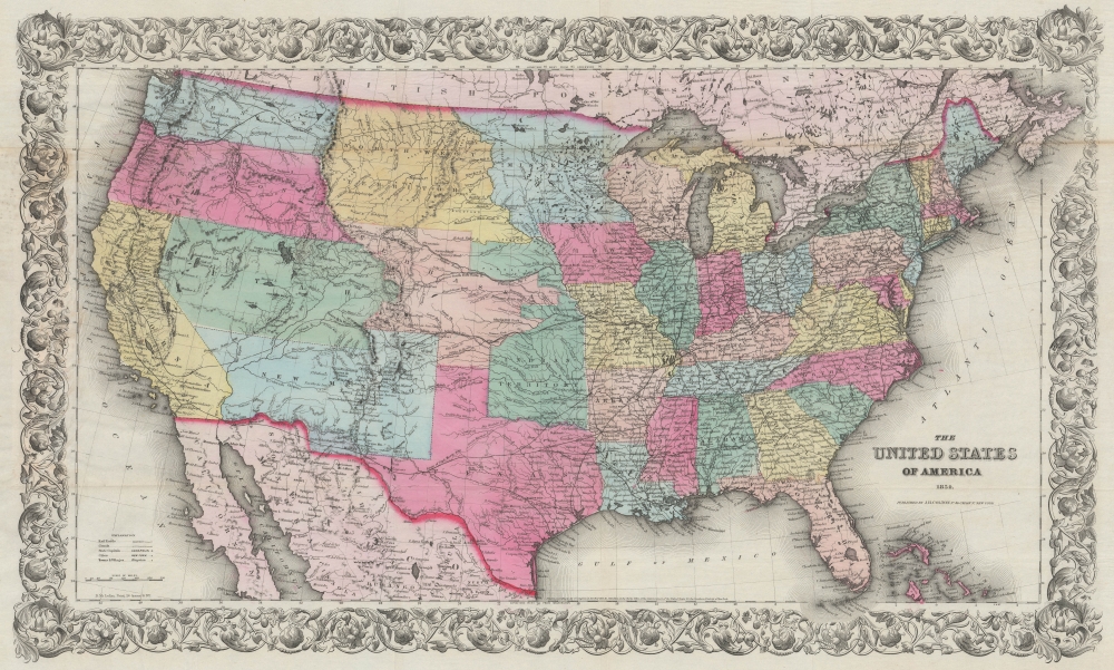
A rare example of J.H. Colton's 1854 map of the United States of America. This is the first iteration of Colton's United States map, issued separately and predating its reduced issue in the iconic atlas of 1855. Among other features, it is notable for providing a snapshot of the rapid territorial changes on the Great Plains and the Western U.S. The early manifestation of Nebraska Territory with unusual territorial, a late curious appearance of Northwest Territory, and the still-uncertain status of the lands acquired through the Gadsden Purchase are particularly noteworthy.
A Closer Look
Covering the entire continental United States along with portions of Canada, Mexico, and the Bahamas, this vibrantly hand-colored map is especially important for the inclusion of ephemeral territorial configurations in the Central and Western United States, reflecting the situation just before the passage of the Kansas-Nebraska Act. Waterways, cities, frontier forts, mountains, mountain passes, railways, major transcontinental wagon routes, and routes taken by explorers and expeditions (such as Frémont's 1843 and 1845 expeditions) are all recorded. Readily apparent are elongated Washington, Oregon, Utah, and New Mexico Territories. Minnesota and the 'Northwest Territory' (future Dakota, along with parts of Montana and Wyoming) are also larger than their ultimate configuration as states. While the term 'Northwest Territory' typically applies to the 1787 Northwest Ordinance lands around Michigan, Wisconsin, and Minnesota, the use of it here is singular and unexplained.Nebraska Territory - Still in the Works
Also especially intriguing is the Nebraska Territory, taking in portions of today's Colorado, Wyoming, and Kansas, and intersecting the strangely-shaped Indian Territory, which extends as far north as the Keya Paha River. For several years before the passage of the Kansas-Nebraska Act, the outlines of a Nebraska Territory had been floated and the territory was nearly incorporated more than once before disagreements over the issue of slavery prevented it. Thus, Colton appears to have expected the territory to be created soon afterwards, but made the map in the early months of 1854, before the compromise was finalized, creating the Kansas Territory in the process.The Gadsden Purchase - Under Negotiation
The uncertainty over the southern border of the New Mexico territory is also reflected here, as the draft of the Gadsden Purchase had been signed in December 1853 but was not ratified by Congress until April 1854, again supporting a date of early 1854 for the map's production. The border proposed by Conde and Bartlett in 1851 is noted along with the later proposal of the American negotiator, Andrew B Gray, which became the ultimate southern border of the eastern portion of the territory. However, the eventual addition of what is now southern Arizona, south of the Gila River, is not included as part of the U.S., resulting in Tucson being displayed as part of Mexico.Potential Transcontinental Railroad Lines
Another curious feature is the inclusion of three transcontinental railroad lines. These were merely conceptual at the time and the first transcontinental railroad would not be completed until 15 years later, mostly along a route not charted here. However, Colton's inclusion of these lines follows government reports of the time, and lines were eventually built roughly along the routes outlined here (the Northern Pacific, Atchison, Topeka and Santa Fe, and Southern Pacific).Publication History and Census
This map was prepared by J.H. Colton and printed by David McLellan in New York. It is copyrighted 1853, but, as discussed above, is updated to reflect the territorial situation of the country in early 1854. It is a separate issue that predates Colton's Universal Atlas. Scarce on the market. Not in Wheat.CartographerS
Joseph Hutchins Colton (July 5, 1800 - July 29, 1893), often publishing as J. H. Colton, was an important American map and atlas publisher active from 1833 to 1897. Colton's firm arose from humble beginnings when he moved to New York in 1831 and befriended the established engraver, Samuel Stiles. He worked under Stiles as the 'Co.' in Stiles and Co. from 1833 to 1836. Colton quickly recognized an emerging market in railroad maps and immigrant guides. Not a cartographer or engraver himself, Colton's initial business practice mostly involved purchasing the copyrights of other cartographers, most notably David H. Burr, and reissuing them with updated engraving and border work. His first maps, produced in 1833, were based on earlier Burr maps and depicted New York State and New York City. Between 1833 and 1855, Colton proceeded to publish a large corpus of guidebooks and railroad maps, which proved popular. In the early 1850s, Colton brought his two sons, George Woolworth Colton (1827 - 1901) and Charles B. Colton (1832 - 1916), into the map business. G. W. Colton, trained as a cartographer and engraver, was particularly inspired by the idea of creating a large and detailed world atlas to compete with established European firms for the U.S. market. In 1855, G.W. Colton issued volume one of the impressive two-volume Colton's Atlas of the World. Volume two followed a year later. Possibly because of the expense of purchasing a two-volume atlas set, the sales of the Atlas of the World did not meet Colton's expectations, and so, in 1856, the firm also issued the atlas as a single volume. The maps contained in this superb work were all original engravings, and most bear an 1855 copyright. All of the maps were surrounded by an attractive spiral motif border that would become a hallmark of Colton's atlas maps well into the 1880s. In 1857, the slightly smaller Colton's General Atlas replaced the Atlas of the World. Most early editions of the General Atlas published from 1857 to 1859 do not have the trademark Colton spiral border, which was removed to allow the maps to fit into a smaller format volume. Their customers must have missed the border because it was reinstated in 1860 and remained in all subsequent publications of the atlas. There were also darker times ahead; in 1858, Colton was commissioned at a sum of 25,000 USD by the government of Bolivia to produce and deliver 10,000 copies of a large format map of that country. Although Colton completed the contract in good faith, delivering the maps at his own expense, he was never paid by Bolivia, which was at the time in the midst of a series of national revolutions. Colton would spend the remainder of his days fighting with the Bolivian and Peruvian governments over this payment, and in the end, after a congressional intervention, he received as much as 100,000 USD in compensation. Nonetheless, at the time, it was a disastrous blow. J. H. Colton and Company is listed as one of New York's failed companies in the postal record of 1859. This led Colton into the arms of Alvin Jewett Johnson and Ross C. Browning. The 1859 edition of Colton's General Atlas lists Johnson and Browning as the 'Successor's to J. H. Colton' suggesting an outright buyout, but given that both companies continued to publish separately, the reality is likely more complex. Whatever the case may have been, this arrangement gave Johnson and Browning access to many of Colton's map plates and gave birth to Johnson's New Illustrated (Steel Plate) Family Atlas. The Johnson's Atlas was published parallel to Colton's atlases well into the 1880s. The Colton firm itself subsequently published several other atlases including an Atlas of America, the Illustrated Cabinet Atlas, the Octavo Atlas of the Union, and Colton's Quarto Atlas of the World. They also published a large corpus of wall maps, pocket maps, and guides. The last known publications of the Colton firm date to 1897 and include a map and a view, both issued in association with the Merchant's Association of New York. Alice M. Colton married August R. Ohman (May 3, 1859 - April 22, 1934) on January 5, 1897. In 1898, Ohman joined the Colton firm, which continued to publish as Colton, Ohman & Co. until 1901. More by this mapmaker...
David McLellan (September 20, 1825 - July 26, 1867) was a Scottish-American lithographer and printer active in New York City in the middle part of the 19th century. McLellan was born Pollockshaws, Renfrewshire, Scotland. He lived in Glasgow for about 20 years, where he mastered printing and lithography under his father James McLellan (1798 - 18??). In 1847, he immigrated to New York City with his brother, James McLellan. David initially printed under his own name, 'David McLellan (1851 - 1854), the with in partnership with his brother, James, as 'D and J. Mclellan' (1855 - 1860). Aging under his own name during the Civil War from 1862 -1863. Then as 'David McLeland and Brothers' (1864 - 1866). He joined the mostly Scottish 79th 'Highlander' Regiment, with whom he participated with the rank of 'Major' in the American Civil War (1862 - 1865). During his long career as a New York lithographer, McLellan worked with many prominent publishers, including J. H. Colton, Edward Valois, James Ackerman, the U.S. Coast Surrey. After his death in 1867 he was interred in Greenwood Cemetery. The McLellan printing business continued after his death under the imprint of John McLellan (1867 - 1868) and J. (John) and R. (Robert) McLellan (1869). No further McLellan work is known after 1869. Learn More...
Condition
Very good. Slight wear on old fold lines. Minor reinforcement were originally attached to binder.
References
OCLC 227480118.