This item has been sold, but you can get on the Waitlist to be notified if another example becomes available, or purchase a digital scan.
1818 Pinkerton Map of the Northern United States
USANorthernPart-pinkerton-1818$225.00

Title
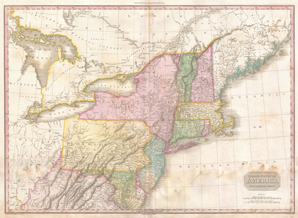
United States of America Northern Part.
1818 (undated) 20.5 x 28 in (52.07 x 71.12 cm)
1818 (undated) 20.5 x 28 in (52.07 x 71.12 cm)
Description
John Pinkerton's highly decorative and important map of the northern parts of the United States, published 1818. Covers from Lake Huron eastward as far as New Brunswick and southwards as far as the Chesapeake Bay. Includes the states of New York, New Jersey, Pennsylvania, Connecticut, Rhode Island, Vermont, New Hampshire, Maryland, Delaware and Virginia. Also includes the districts of Maine, parts of the Western Territory, including Michigan and Ohio, and adjacent portions of Canada.
Pinkerton's map is full of interesting detail from the American Indian lands in the western portions of the map, to notations on river navigation, to the configuration of the early states. Notes Connecticut's Western reserve in what is today Ohio. This territory was a legacy of Connecticut's original coast to coast charter and we settled in the early 19th century by New England emigrants.
Drawn by L. Herbert and engraved by Samuel Neele under the direction of John Pinkerton. This map comes from the scarce American edition of Pinkerton's Modern Atlas, published by Thomas Dobson & Co. of Philadelphia in 1818.
CartographerS
John Pinkerton (February 17, 1758 - March 10, 1826) was an Scottish writer, historian, and cartographer. Pinkerton was born in Edinburgh, Scotland. He was a studious youth with a passion for the classics. As a young man, he studied at Edinburgh University before apprenticing as a lawyer. Around this time, he began writing, with his first book, Elegy on Craigmillar Castle published in 1776. Pinkerton moved to London in 1781 to pursue his writing career in earnest. He successfully published several works of literature, poetry, and history. Pinkerton proved passionate in his literary and historical writings, but his correspondence with other cartographers has been labeled as aggressive, even insane. In addition to his work as a writer and historian, Pinkerton was one of the leading masters of the Edinburgh school of cartography which flourished from roughly 1800 to 1830. Pinkerton and his contemporaries (Thomson and Cary) redefined European cartography by abandoning typical 18th century decorative elements such as elaborate title cartouches and fantastical beasts in favor of detail and accuracy. Pinkerton's principle work is Pinkerton's Modern Atlas published from 1808 through 1815 with a special American reissue by Dobson and Co. in 1818. Pinkerton relocated to Paris in 1818, where he managed his publishing business until his death in 1826. More by this mapmaker...
Thomas Dobson (1751 - 1823) was an American publisher active in Philadelphia during the late 18th and early 19th centuries. Dobson was born in Edinburgh, Scotland in 1751 and emigrated to Philadelphia c. 1780. In Philadelphia, he established a successful printing business by republishing edited and updated versions of important British reference materials in matching quality but at a much lower price point. He is best known for publishing the first American edition of the Encyclopedia Britannica. He also published America's first Hebrew Bible. Cartographically Dobson's most notable work is 1818 republication of Pinkerton's fantastic Modern Atlas. Learn More...
Source
Pinkerton, J., A Modern Atlas, from the Lates and Best Authorities, Exhibiting the Various Divisions of the World with its chief Empires, Kingdoms, and States; in Sixty Maps, carefully reduced from the Larges and Most Authentic Sources. 1818, Philadelphia, Thomas Dobson Edition.
Condition
Good condition. Original centerfold. Dampstaining in lower quadrants - please examine image - for which we have discounted this normally 750 USD map. Blank on verso.
References
Rumsey 0732.043. Phillips (Atlases) 724. National Maritime Museum, 409.