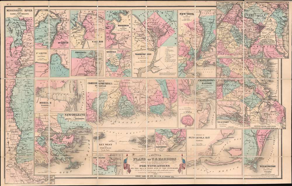
1862 Colton Civil War Map of the United States Detailing Harbors
USHarbors-colton-1862$3,000.00


Title
Colton's Plans of U.S. Harbors Showing the Position and Vicinities of the Most Important Fortifications on the Sea-Board and in the Interior.
1862 (dated) 20 x 31.5 in (50.8 x 80.01 cm)
1862 (dated) 20 x 31.5 in (50.8 x 80.01 cm)
Description
This is a separate issue 1862 J. H. Colton map of the United States focusing on its many harbors and their fortifications during the American Civil War (1861 - 1865). Twenty-one plans are printed on a single sheet. Colton highlights the most important ports in both the Union and the Confederacy. Maps highlight New York City, Washington D.C., Charleston, eastern Virginia from the Chesapeake Bay west to Richmond and Petersburg, Pensacola, Galveston, Savannah, Charleston, Mobile Bay, and New Orleans. An inset in the Charleston Harbor map details Fort Sumter, where the first shots of the American Civil War were fired.
The Mississippi River
The most important aspect of this map, given the American Civil War, is Colton's detail of Mississippi River ports. Plans of Cairo, Memphis, Louisville, and St. Louis appear on the upper left. For this edition, Colton added a map of the Mississippi River from Cairo to New Orleans, highlighting the significance of controlling the Mississippi corridor to both sides of the conflict.Railroads
Colton details the railroad networks surrounding each city and illustrates and labels railroad lines in each map. For example, the map entitled 'Norfolk, Fortress Monroe, James River, Richmond, Petersburgh, etc.' provides a detailed depiction of the network connecting Richmond, Petersburg, Suffolk, and Norfolk, and in doing so underscores the important role railroads played throughout the war.Publication History and Census
This map was created and published by J.H. Colton in 1862 and printed by Lang and Laing in New York City. This particular example bears a pastedown over Colton's copyright stating that this example of the map was sold in London by 'Sampson Low, Son, and Company'. We have been unable to locate any other examples bearing this pastedown, but it is likely the reason this map is dissected and laid on linen - a very British predilection uncommon in mid-sized American maps. At least two editions were published. The first, published in 1861, did not include the important Mississippi River inset, which was added for this, the second edition. This map is well represented in institutional collections but is scarce on the private market.CartographerS
Joseph Hutchins Colton (July 5, 1800 - July 29, 1893), often publishing as J. H. Colton, was an important American map and atlas publisher active from 1833 to 1897. Colton's firm arose from humble beginnings when he moved to New York in 1831 and befriended the established engraver, Samuel Stiles. He worked under Stiles as the 'Co.' in Stiles and Co. from 1833 to 1836. Colton quickly recognized an emerging market in railroad maps and immigrant guides. Not a cartographer or engraver himself, Colton's initial business practice mostly involved purchasing the copyrights of other cartographers, most notably David H. Burr, and reissuing them with updated engraving and border work. His first maps, produced in 1833, were based on earlier Burr maps and depicted New York State and New York City. Between 1833 and 1855, Colton proceeded to publish a large corpus of guidebooks and railroad maps, which proved popular. In the early 1850s, Colton brought his two sons, George Woolworth Colton (1827 - 1901) and Charles B. Colton (1832 - 1916), into the map business. G. W. Colton, trained as a cartographer and engraver, was particularly inspired by the idea of creating a large and detailed world atlas to compete with established European firms for the U.S. market. In 1855, G.W. Colton issued volume one of the impressive two-volume Colton's Atlas of the World. Volume two followed a year later. Possibly because of the expense of purchasing a two-volume atlas set, the sales of the Atlas of the World did not meet Colton's expectations, and so, in 1856, the firm also issued the atlas as a single volume. The maps contained in this superb work were all original engravings, and most bear an 1855 copyright. All of the maps were surrounded by an attractive spiral motif border that would become a hallmark of Colton's atlas maps well into the 1880s. In 1857, the slightly smaller Colton's General Atlas replaced the Atlas of the World. Most early editions of the General Atlas published from 1857 to 1859 do not have the trademark Colton spiral border, which was removed to allow the maps to fit into a smaller format volume. Their customers must have missed the border because it was reinstated in 1860 and remained in all subsequent publications of the atlas. There were also darker times ahead; in 1858, Colton was commissioned at a sum of 25,000 USD by the government of Bolivia to produce and deliver 10,000 copies of a large format map of that country. Although Colton completed the contract in good faith, delivering the maps at his own expense, he was never paid by Bolivia, which was at the time in the midst of a series of national revolutions. Colton would spend the remainder of his days fighting with the Bolivian and Peruvian governments over this payment, and in the end, after a congressional intervention, he received as much as 100,000 USD in compensation. Nonetheless, at the time, it was a disastrous blow. J. H. Colton and Company is listed as one of New York's failed companies in the postal record of 1859. This led Colton into the arms of Alvin Jewett Johnson and Ross C. Browning. The 1859 edition of Colton's General Atlas lists Johnson and Browning as the 'Successor's to J. H. Colton' suggesting an outright buyout, but given that both companies continued to publish separately, the reality is likely more complex. Whatever the case may have been, this arrangement gave Johnson and Browning access to many of Colton's map plates and gave birth to Johnson's New Illustrated (Steel Plate) Family Atlas. The Johnson's Atlas was published parallel to Colton's atlases well into the 1880s. The Colton firm itself subsequently published several other atlases including an Atlas of America, the Illustrated Cabinet Atlas, the Octavo Atlas of the Union, and Colton's Quarto Atlas of the World. They also published a large corpus of wall maps, pocket maps, and guides. The last known publications of the Colton firm date to 1897 and include a map and a view, both issued in association with the Merchant's Association of New York. Alice M. Colton married August R. Ohman (May 3, 1859 - April 22, 1934) on January 5, 1897. In 1898, Ohman joined the Colton firm, which continued to publish as Colton, Ohman & Co. until 1901. More by this mapmaker...
Lang and Laing (fl. 1861 – August 16, 1862) were New York City based publishers and lithographers active in the middle part of the 19th century. The firm was founded by founded by William Lang and Joseph Laing and maintained offices at 117 Fulton Street, New York City. They specialized in transferring copper and steel plates to lithographic stone for more economical printing. Their most significant cartographic work is the Jacob de Cordova and Robert Creuzbaur map of Texas. The firm was dissolved in August of 1862. Lang went on to partered with Henry Pooley Cooper, and continued to publish under the Lang and Cooper imprint until 1864. Learn More...
Sampson Low (November 18, 1797 - April 16, 1886) was an English publisher and bookseller. Born in London, Low, the son of a printer and publisher working in Soho, held an apprenticeship with the proprietor of a circulating library and worked in the house of Longman and Company before opening his own business in 1819. Operating out of 42 Lamb's Conduit Street, Low's first business was as a bookseller and stationer with an attached circulating library. Low founded Sampson Low, Son, and Company in 1848 with his eldest son Sampson Low, Jr. on Fleet Street. The business moved to Ludgate Hill in 1852 and expanded to include an American department with the help of David Bogue. Bogue retired in 1856. That year, Edward Marston was brought on as a partner and the firm's name changed to Sampson Low, Son and Marston. After Low Jr. died in 1871, the firm's name changed again, this time to Sampson Low, Marston and Company. Low retired in 1875 and his wife Mary, with whom he had two sons, died on May 26, 1881. The firm continued until 1964. Learn More...
Condition
Very good. Dissected and mounted on linen in eighteen (18) panels.
References
Rumsey 3813.001. OCLC 43978665; 70834889.