This item has been sold, but you can get on the Waitlist to be notified if another example becomes available, or purchase a digital scan.
1864 Eldridge Blueback Nautical Chart Map of Marthas Vineyard and Nantucket
VineyardSoundNantucketShoals-eldridge-1864$1,400.00

Title
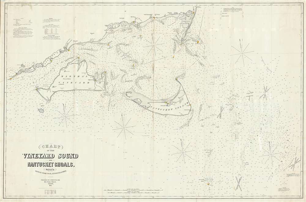
Chart of the Vineyard Sound and Nantucket Shoals, Surveyed by George Eldrdige, Hydrographer.
1864 (dated) 40 x 62 in (101.6 x 157.48 cm) 1 : 88500
1864 (dated) 40 x 62 in (101.6 x 157.48 cm) 1 : 88500
Description
This is George Eldridge’s enormous and important large-format 1864 blueback nautical chart of the waters around Nantucket and Martha’s Vineyard, including Vineyard Sound and the Nantucket Shoals. Most likely Eldridge's most important and useful publication, this chart offers hundreds of depth soundings, along with notations about shoals and other hazards, lighthouses and other aids to navigation, tides, currents and compass variations, sailing directions, and other information pertinent to the mariner. The staggering size of this map as well as its extraordinary overall detail underscore the importance of these waters not only as an international shipping channel, but also for the vibrant local maritime community, of which included Eldridge. The present chart is one of Eldridge’s most important charts with an active period of more than 40 years.
Although we have identified many examples of this chart in other editions, this is one of only two examples of the 1864 issue known, the other being in the British Library. It is conceivable that Eldridge and Thaxter, aware that the major copyright update of 1865 was about to be issued, chose to limit production of the 1864 issue.
Charting Nantucket Waters
The waters around Martha's Vineyard and Nantucket were long considered dangerous and difficult to navigate despite being both an important maritime artery on the London-New York shipping route, and an essential fishery. The harsh conditions, including rapid unexpected swells and frequent heavy fog, contrived to make the hazards south of Nantucket and Martha's Vineyard some of the most dangerous and challenging areas to hydrographically survey. Moreover, there were a plethora of poorly realized, outdated, and outright speculative commercial charts, many coming from British publishers incorporating data dating to the Revolutionary War. For these reasons, the U.S. Coast Survey chose the Nantucket-Martha's Vineyard-Buzzard Bay corridor as the focus for their earliest charting efforts. Under Lieutenant Commander Charles H. Davis, these waters slowly took shape, with excellent detailed surveys, performed over numerous years under harsh conditions ultimately revealing the inaccuracies of earlier efforts. What the U.S.C.S. failed to produce until around 1860, were large format nautical charts useful for the mariner - instead their publications were limited to small format maps in bound congressional reports. Until the U.S.C.S. began issuing its own superior large format charts, most of their charting efforts, as they impacted the day-to-day mariner, were consolidated by private chart publishing houses, like Blunt and Eldridge. In particular, Eldridge's work around Martha's Vineyard and Nantucket, became highly influential and remained in use well into the 20th century.Blueback Charts
Blueback nautical charts began appearing in London in the late 18th century. Bluebacks, as they came to be called, were privately published large format nautical charts known for their distinctive blue paper backing. The backing, a commonly available blue manila paper traditionally used by publishers to warp unbound pamphlets, was adopted as a practical way to reinforce the low-quality paper used by private chart publishers in an effort to cut costs. The earliest known blueback charts include a 1760 chart issued by Mount and Page, and a 1787 chart issued by Robert Sayer. The tradition took off in the early 19th century, when British publishers like John Hamilton Moore, Robert Blachford, James Imray, William Heather, John William Norie, Charles Wilson, David Steel, R. H. Laurie, and John Hobbs, among others, rose to dominate the chart trade. Bluebacks became so popular that the convention was embraced by chartmakers outside of England, including Americans Edmund March Blunt and George Eldridge, as well as Scandinavian, French, German, Russian, and Spanish chartmakers. Blueback charts remained popular until the late 19th century, when government subsidized organizations like the British Admiralty Hydrographic Office and the United States Coast Survey, began issuing their own superior charts on high quality paper that did not require reinforcement.Publication History and Census
George Eldridge first issued this chart in 1857 as an update to his earlier Chart of Vineyard Sound, From Chatham Lights to Gay Head. The map is copyrighted, 1857, in partnership with Samuel T. (Thaxter) Cushing (1821 - 1882), the publisher. It was updated and reissued in 1864, as the present example. In 1865 a new copyright was filed, and subsequent editions bear an 1865 copyright, leading some to mistakenly believe 1865 the first edition. Subsequent editions are cataloged in 1874, 1883, and 1891. The map was engraved George Washington Boynton, and published by Samuel Thaxter and Son of Boston.Although we have identified many examples of this chart in other editions, this is one of only two examples of the 1864 issue known, the other being in the British Library. It is conceivable that Eldridge and Thaxter, aware that the major copyright update of 1865 was about to be issued, chose to limit production of the 1864 issue.
CartographerS
George Eldridge (November 27, 1821 - August 23, 1900) and his son George Washington Eldridge (1845 - 1914) were American makers of nautical charts and Pilot Books active in the late 19th century. George Eldridge was a Cape Cod fisherman known locally as an excellent ship's pilot. While recuperating from an injury in 1851, Eldridge drew his first nautical chart. The chart proved popular, and its success led Eldridge to pursue a career in hydrography - the science of mapping the sea with a special focus on navigation. Eldridge produced numerous subsequent maps and is credited with issuing some of the earliest accurate nautical charts of the American Atlantic coast. In time George Eldridge passed his thriving business on to his son, George Washington Eldridge, who continued to produce beautiful and practical maritime charts until 1924.Though most of Eldridge's charts were loosely based on U.S. Coast Survey work, they proved popular with navigators. The Eldridges possessed a talent, shared by both father and son, for distilling the often convoluted Coast Survey maps into practical nautical charts for the working mariner. From 1875, in addition to large format independently issued nautical charts, Eldridge also issued annual editions of Eldridge's Tide and Pilot Book and The Book of Harbor Charts. The Eldridge offices were located at 103 State St. Boston, Massachusetts. After the deaths of George and George Washington Eldridge, the firm passed into the hands of the latter's widow Sydna, and son-in-law, Wilfrid O. Wight. Wight's son and subsequent generations have continued to publish the Eldridge Tide and Pilot Book down to the present. More by this mapmaker...
Samuel Thaxter and Son (fl. 1792 - 1916). Samuel Thaxter (1769 - 1842) is the founder of a Boston dynasty of manufacturers of mathematical instruments and nautical charts. He founded the firm in 1792 and is first referenced in the 1796 Boston Directory. Around 1822 he incorporated his son, Joseph H. Thaxter (1801 - 1835), into the business renaming it 'Samuel Thaxter and Son'. The firm would retain this name for the remainder of its existence. This successful business was subsequently passed to Joseph H. Thaxter's son, Samuel Thaxter Cushing (1821 - 1882), in 1843. It was Thaxter Cushing who developed the firm's publishing arm, partnering with the Boston nautical chart maker George Eldridge. They are best known for 13 large format blueback charts focusing on the east cost of the United States published in the second half of the 19th century. They also published numerous smaller maps and pilot books. After Thaxter Cushing died the firm was taken over by his widow, Abby C. Cushing, who managed it until 1905. It was subsequently managed by Herbert Risteen Starratt and continued to be registered in the Boston Directory until about 1916. Learn More...
George Washington Boynton (fl. c. 1830 - 1850) was a Boston based cartographer and map engraver active in the first half of the 19th century. Boynton engraved and compiled maps for numerous publishers including Thomas Bradford, Nathaniel Dearborn, Daniel Adams, and S. G. Goodrich. His most significant work is most likely his engraving of various maps for Bradford's Illustrated Atlas, Geographical, Statistical, and Historical, of the United States and the Adjacent Countries and Universal Illustrated Atlas. He also engraved for the Boston Almanac. In 1835, Boynton is listed as an employee of the Boston Bewick Company, an engraving, stereotype, and printing concern based at no. 47 Court Street, Boston. Little else is known of his life. Learn More...
Condition
Very good. Some wear and discoloration on old lines. Remounted on fresh blueback paper.
References
OCLC 557848865.