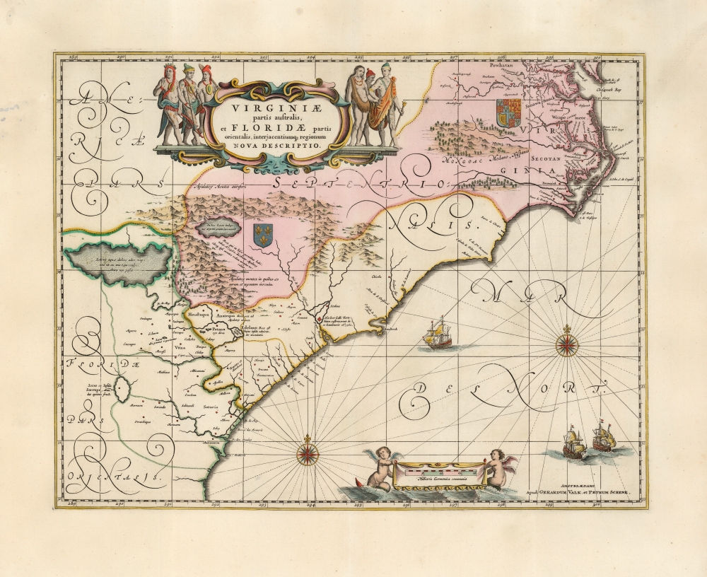
1639 / 1694 Jansson / Valk / Schenk Map of Carolina, Georgia, Florida, Virginia
VirginiaeFloridae-jansson-1694$1,800.00

Title
Virginiae Partis australis, et Floridae partis orientalis, interjacentiumque regionum Nova Descriptio.
1694 (undated) 15 x 19.5 in (38.1 x 49.53 cm) 1 : 2300000
1694 (undated) 15 x 19.5 in (38.1 x 49.53 cm) 1 : 2300000
Description
This is Jan Jansson's beautiful map of Virginia and Florida, engraved in 1639, appearing here in an attractive example of its c. 1694 restrike under the imprint of Gerard Valk and Peter Schenk. This classic Dutch map, encompassing the Carolinas and what would become Georgia and part of Florida, was derived from that of Willem Blaeu, which has been called 'the most correct map of this area yet to appear' (Cumming). Blaeu's map was sufficiently authoritative for Jansson to make an extremely faithful copy. Both cartographers' maps would have a long print life.
The Map and its Sources
In terms of its scope, the map covers the same region presented in the 1606 Jodocus Hondius Virginia Item et Floridae, but improves greatly in the detail. While the earlier Hondius relied on the geographic models presented in the late 16th century John White and Le Moyne maps, the present map includes the new cartographic data provided in the far superior, c. 1631 charts of Hessel Gerritz - most notably improving the delineation of the Outer Banks of the Carolinas, and the mouth of Chesapeake Bay. While many of the place names still derive from earlier maps, there are important advances. The settlement in 1621 of Newport News appeared on Blaeu's 1638 version of this map for the first time, for example. Areas in the interior still appear to rely heavily the 1591 Le Moyne map - in particular the large Appalachian lake advertising the presence of native-gathered silver.A Long Tale of French and English Colonial Rivalry
The contesting claims to this stretch of American coast by the English and French not only appear in this map, but are inherent to the map's earliest precedents. Despite the much-improved coastlines after Gerritz, the core of the map's Virginia/Florida division has its roots in the two De Bry maps of these regions, and these were expressly maps of an English Colony (Virginia) and the French efforts to colonize further south (Florida). Both regions bear coats of arms associating them with the relevant colonizing power. Elements such as the doomed fortress built by Laudonnière in 1562 in French Florida (and destroyed in 1565 by Pedro Menéndez de Avilés) further advertise the map's lineage.Classic Dutch Decorative Elements
The engraving exhibits a clear and legible style, while not neglecting the decorative elements which characterize the finest maps of the Dutch Golden Age. Mountains and forests are rendered pictorially. The elegant cartouche is flanked by six Native American figures. The English coat of arms is displayed in Virginia, whilst the French arms reflect efforts to colonize Florida in the 1560s. The sea areas are embellished with two fine compass roses, and three sailing ships. A banner displaying the scale in German miles is suspended between a pair of bat-winged, fish-tailed mer-putti.Close Copies by Fierce Competitors
The publication of this map in the 1639 French issue of the Jansson/ Hondius atlas puts it ever-so-narrowly behind the cartographically virtually identical 1638 map printed by Jansson's primary competitor, Blaeu. The two maps are frequently mistaken for one another, due to the lack of printer's imprint on either. There are nonetheless telltales which identify the Jansson clearly. First, the tribal names 'Powhatan' and 'Secotan' in the region of Virginia lack full stops, the punctuation present in the Blaeu. There is as well an error in the Blaeu not present in his competitor's map: in the lower right of the Blaeu, the sequence of longitude reads '298, 299, 200' whilst the Jansson map has this corrected to '298, 299, 300.'Publication History and Census
This map was engraved by Jan Jansson, first appearing in the 1639 French edition of the Nouvel Atlas. Thereafter it appeared in every edition of the Jansson atlases, all in a single state. At some point after 1680, the Amsterdam publishers Gerard Valk and Peter Schenk acquired the plate and re-printed it, having added their imprint to the lower right corner. The separate map, in its many editions, is well-represented in institutional collections, although it should be noted that the map is frequently misidentified as the Jansson, and vice-versa. Only three examples of this second, Valk and Schenk state are catalogued separately in OCLC, although these have appeared on the market from time to time.CartographerS
Jan Jansson or Johannes Janssonius (1588 - 1664) was born in Arnhem, Holland. He was the son of a printer and bookseller and in 1612 married into the cartographically prominent Hondius family. Following his marriage he moved to Amsterdam where he worked as a book publisher. It was not until 1616 that Jansson produced his first maps, most of which were heavily influenced by Blaeu. In the mid 1630s Jansson partnered with his brother-in-law, Henricus Hondius, to produce his important work, the eleven volume Atlas Major. About this time, Jansson's name also begins to appear on Hondius reissues of notable Mercator/Hondius atlases. Jansson's last major work was his issue of the 1646 full edition of Jansson's English Country Maps. Following Jansson's death in 1664 the company was taken over by Jansson's brother-in-law Johannes Waesberger. Waesberger adopted the name of Jansonius and published a new Atlas Contractus in two volumes with Jansson's other son-in-law Elizée Weyerstraet with the imprint 'Joannis Janssonii haeredes' in 1666. These maps also refer to the firm of Janssonius-Waesbergius. The name of Moses Pitt, an English map publisher, was added to the Janssonius-Waesbergius imprint for maps printed in England for use in Pitt's English Atlas. More by this mapmaker...
Gerard Valk (September 30, 1652 - October 21, 1726) (aka. Valck, Walck, Valcke), was a Dutch engraver, globe maker, and map publisher active in Amsterdam in the latter half of the 17th century and early 18th century. Valk was born in Amsterdam where his father, Leendert Gerritsz, was a silversmith. He studied mathematics, navigation, and cartography under Pieter Maasz Smit. Valk and moved to London in 1673, where he studied engraving under Abraham Blooteling (or Bloteling) (1634 - 1690), whose sister he married, and later worked for the map sellers Christopher Browne and David Loggan. Valke and Blooteling returned to Amsterdam in 1680 and applied for a 15-year privilege, a kind of early copyright, from the States General, which was granted in 1684. In 1687, he established his own firm in Amsterdam in partnership with Petrus (Pieter) Schenk, who had just married his sister, Agata. They published under the imprint of Valk and Schenk. Also, curiously in the same year Valk acquired the home of Jochem Bormeester, also engraver and son-in-law of art dealer Clement De Jonghe. Initially Valk and Schenk focused on maps and atlases, acquiring the map plates of Jodocus Hondius and Jan Jansson in 1694. Later, in 1701 they moved into the former Hendrick Hondius (the younger) offices where they began producing globes. Valk and Schenk soon acquired the reputation of producing the finest globes in the Netherlands, a business on which they held a near monopoly for nearly 50 years. In 1702, Valk joined the Bookseller's Guild of which he was promptly elected head. Around the same time, Gerard introduced his son, Leonard, who was married to Maria Schenk, to the business. Leonard spearheaded the acquisition of the map plates of Frederick de Wit in 1709. Nonetheless, Leonard was nowhere near as sophisticated a cartographer or businessman as his father and ultimately, through neglect, lost much the firm's prestige. After his death, the firm was taken over by his widow Maria. Learn More...
Petrus Schenk (Pieter Schenck) the Elder (December 26, 1660 - 1711) was a Dutch engraver, globe maker, and map publisher active in Amsterdam and Leipzig in the latter half of the 17th century. Schenk, was born in Elberfield, Germany. He moved in Amsterdam in 1675, becoming the apprentice to Gerard Valk (Valck). In 1687, Schenk married Agatha Valk, Gerard Valk's sister and went into partnership with his brother-in-law under the imprint of 'Valk and Schenk'. Initially they focused on maps and atlases, acquiring the map plates of Jan Jansson and Jodocus Hondius in 1694. Later, in 1701 they moved into the former Hondius offices where they began producing globes. Valk and Schenk quickly became known for producing the best globes in the Netherlands, a business on which they held a near monopoly for nearly 50 years. Schenk's three sons, Pieter Schenk the Younger, Jan Schenk, and Leonard Schenk, all became engravers in their own right. Pieter Schenk the Younger inherited the business and ran his father's shop in Leipzig. His daughter, Maria Schenk, married Leonard Valk, the son of Gerard Valk, and continued to run the Valk and Schenk map engraving workshop in Amsterdam. Learn More...
Condition
Very good. Fine original color, refreshed. No verso text. Few spots, else excellent.
References
OCLC 985570265. Burden, P., The Mapping of North America, #254 state 2. Cumming, W., The Southeast in Early Maps, #42.