This item has been sold, but you can get on the Waitlist to be notified if another example becomes available, or purchase a digital scan.
1755 Vaugondy Map of the Chesapeake Bay, Virginia, Maryland, and Delaware
VirginieMaryland-vaugondy-1755$1,900.00

Title
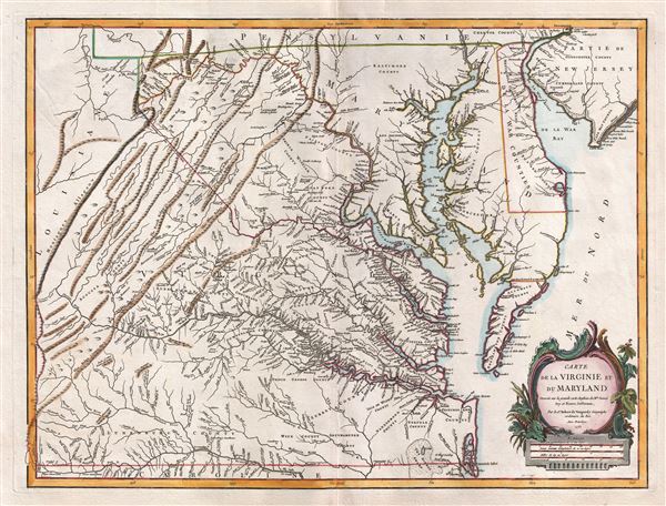
Carte de la Virginie et du Maryland.
1755 (dated) 19.5 x 26 in (49.53 x 66.04 cm) 1 : 870000
1755 (dated) 19.5 x 26 in (49.53 x 66.04 cm) 1 : 870000
Description
A fine first edition example of Robert de Vaugondy's 1755 map of the Virginian, Delaware, and Maryland, including the Chesapeake Bay. The map extends from the Allegany Mountains eastward to the Chesapeake Bay, Delaware Bay, and Atlantic Ocean. He also includes parts of adjacent New Jersey, Pennsylvania, and North Carolina. Cartographically Vaugondy derives this map from the Virginia-Maryland portions of the 1755 Dalrymple edition of the Fry-Jefferson map.
The Fry-Jefferson Map, from which this map is derived, initially issued in 1751, was the first major mapping of Virginia to deviate from the conventions laid down by the 1612 John Smith map. Unlike the Smith Map, the Fry-Jefferson map evolved from actual on-site survey work completed by Joshua Fry and Peter Jefferson. This map disseminated some of the first accurate data regarding the interior of Virginia.
Vaugondy's map offers a wealth of interesting detail. These include two stunted wagon routes extending west from Maryland, then across the Potomac, that seem to fade away as they head southwest towards Frederick. Another stunted path to the west of the Blue Ridge Mountains is labeled 'Route Indianne.' The limits of Lord Fairfax's massive grant are outlined in red - a feature limited to this first edition of Vaugondy's map. Throughout mills, settlements, and even American Indian lands are noted.This map exists in five known states of which this is the first. The first state is identifiable by the inclusion of the 'Limites of Lord Fairfax.' The map itself was engraved by the Delayahe family and the cartouche was engraved (and signed) by Elizabeth Hussard. This was published in the 1857 first edition of the Atlas Universel
The Fry-Jefferson Map, from which this map is derived, initially issued in 1751, was the first major mapping of Virginia to deviate from the conventions laid down by the 1612 John Smith map. Unlike the Smith Map, the Fry-Jefferson map evolved from actual on-site survey work completed by Joshua Fry and Peter Jefferson. This map disseminated some of the first accurate data regarding the interior of Virginia.
Vaugondy's map offers a wealth of interesting detail. These include two stunted wagon routes extending west from Maryland, then across the Potomac, that seem to fade away as they head southwest towards Frederick. Another stunted path to the west of the Blue Ridge Mountains is labeled 'Route Indianne.' The limits of Lord Fairfax's massive grant are outlined in red - a feature limited to this first edition of Vaugondy's map. Throughout mills, settlements, and even American Indian lands are noted.
CartographerS
Robert de Vaugondy (fl. c. 1716 - 1786) was French may publishing from run by brothers Gilles (1688 - 1766) and Didier (c. 1723 - 1786) Robert de Vaugondy. They were map publishers, engravers, and cartographers active in Paris during the mid-18th century. The father and son team were the inheritors to the important Nicolas Sanson (1600 - 1667) cartographic firm whose stock supplied much of their initial material. Graduating from Sanson's maps, Gilles, and more particularly Didier, began to produce their own substantial corpus. The Vaugondys were well-respected for the detail and accuracy of their maps, for which they capitalized on the resources of 18th-century Paris to compile the most accurate and fantasy-free maps possible. The Vaugondys compiled each map based on their own geographic knowledge, scholarly research, journals of contemporary explorers and missionaries, and direct astronomical observation. Moreover, unlike many cartographers of this period, they took pains to reference their sources. Nevertheless, even in 18th-century Paris, geographical knowledge was limited - especially regarding those unexplored portions of the world, including the poles, the Pacific Northwest of America, and the interiors of Africa, Australia, and South America. In these areas, the Vaugondys, like their rivals De L'Isle and Buache, must be considered speculative or positivist geographers. Speculative geography was a genre of mapmaking that evolved in Europe, particularly Paris, in the middle to late 18th century. Cartographers in this genre would fill in unknown lands with theories based on their knowledge of cartography, personal geographical theories, and often dubious primary source material gathered by explorers. This approach, which attempted to use the known to validate the unknown, naturally engendered rivalries. Vaugondy's feuds with other cartographers, most specifically Phillipe Buache, resulted in numerous conflicting papers presented before the Academie des Sciences, of which both were members. The era of speculative cartography effectively ended with the late 18th-century explorations of Captain Cook, Jean Francois de Galaup de La Perouse, and George Vancouver. After Didier died, his maps were acquired by Jean-Baptiste Fortin, who in 1787 sold them to Charles-François Delamarche (1740 - 1817). While Delamarche prospered from the Vaugondy maps, he defrauded Vaugondy's window Marie Louise Rosalie Dangy of her rightful inheritance and may even have killed her. More by this mapmaker...
Guillaume-Nicolas Delahaye (1725 - February 24, 1802) was the most prolific member of the Delahaye (De-La-Haye) family of engravers active in Paris throughout the 18th century. Given that the name, Delahaye literally translates to 'of the Hague' it can be assume they were French Huguenots who were forced to flee the Netherlands under threat of religious persecution. Born in Paris, he was the son of patriarch Jean-Baptiste Delahaye and brother to Jean-Baptistie-Henri Delahaye. It is said that his godfather, who held him at the baptismal font, was none other than the famous french cartographer Guillaume de L'Isle. The Delahaye family engraved for many of the great cartographers of 18th century Paris, including Jean-Baptiste Bourguignon d'Anville, Didier Robert de Vaugondy, Jean-Baptiste de Mannevillette, and Jean-Nicolas Buache, among others. He was awarded the public office Premier Graveur du Roi and worked on a series of maps illustrating the king's hunts around Versailles. Guillaume also worked with foreign cartographers such as Tomas Lopez of Madrid. Possibly Delahaye's most significant map is A Map of the Country between Albemarle Sound and Lake Erie prepared for the memories of Thomas Jefferson. He married in 1758. In total he engraved some 1200 maps. Delahaye died in Charenton. In 1792, his daughter, Antoinette Marie Delahaye (1773-1857), married the geographer Jean-Denis Barbie du Bocage. Learn More...
Source
Robert de Vaugondy, G., Atlas Universel, (Paris: Antoine Boudet) 1757.
The Atlas Universel was the crowning glory of the Robert de Vaugondy firm's atlas production. The atlas was revolutionary on many levels and exemplified the Vaugondy credo commode, complet, univorme, et suive (convenient, complete, uniform, and easy to use). The atlas thus consisted of a wide corpus of maps, both modern and historical, was of moderate height and width, and featured maps of uniform style and structure. They partnered with Antoine Boudet, a shrewd businessman and publisher with whom they had worked previously, to produce the 1752 first edition. To minimize his fiscal risk, Boudet sold the atlas first by subscription using a large prospectus, receiving in the process over 1100 pre-orders. The first edition appeared in 1752 and contained beautifully produced maps with elaborate freshly designed allegorical cartouche work, generally by Pierre-Edme Babel, Pierre Philippe Choffard, and Charles Nicholas Cochin. Most of the maps were engraved by the Delahaye firm, the payment for whose services ultimately led to legal disputes. Despite proving a popular work of astounding quality, the Atlas Universal received harsh criticism from fellow cartographers, particularly Philipppe Buache. Ever at odds with the Vaugondys, Buache's critical perspective may have been influenced more by political maneuvering than academic affront. The atlas was issued in multiple editions between 1752 and 1788. Later editions, issued after 1786, were taken over by Charles Delamarche, who inherited the Robert de Vaugondy firm and assumed Boudet's publication rights.
Condition
Very good. Original centerfold. Plate mark visible. Wide margins. Blank on verso.
References
Rumsey 3353.101. OCLC 51199220. Pedley, M. A., Bel et Utile: The Work of the Robert de Vaugondy Family of Mapmakers, no 470, state 1. Cumming, W., The Southeast in Early Maps, 281.