This item has been sold, but you can get on the Waitlist to be notified if another example becomes available, or purchase a digital scan.
1859 Direccion Hidrografia Nautical Chart or Map of the Virgin Islands
VirginIslands-direccionhidrografia-1859$1,500.00

Title
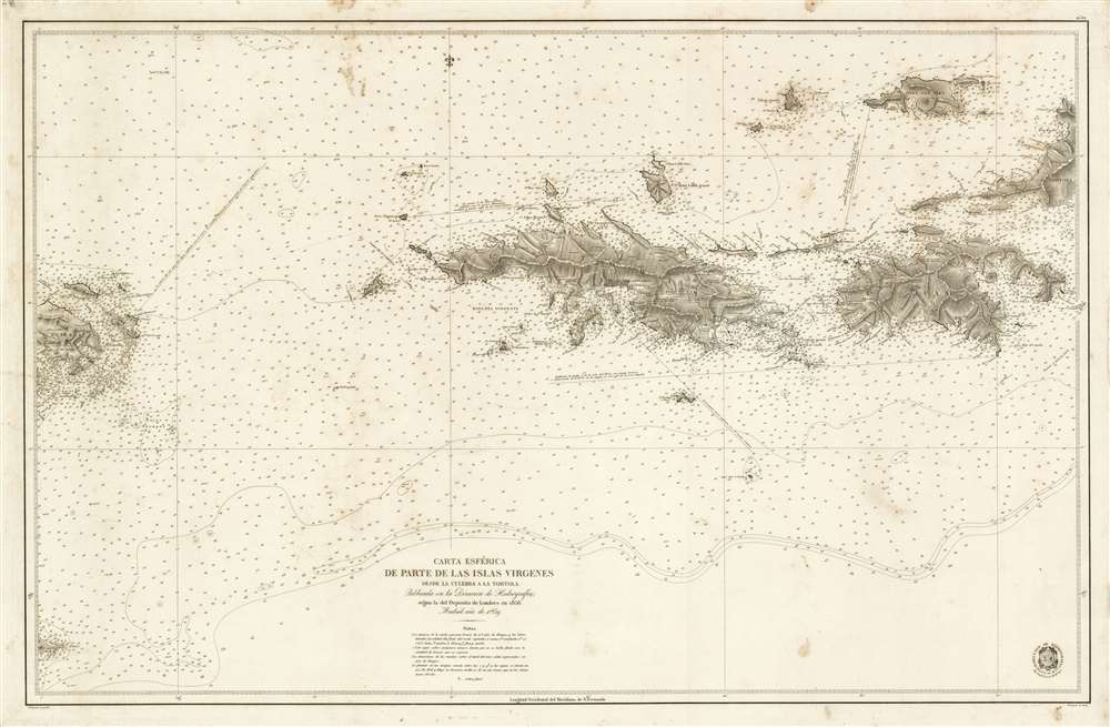
Carta Esférica de Parte de Las Islas Virgenes desde la Culebra a La Tortola.
1859 (dated) 26 x 39.5 in (66.04 x 100.33 cm) 1 : 70000
1859 (dated) 26 x 39.5 in (66.04 x 100.33 cm) 1 : 70000
Description
A stunningly engraved 1859 Dirección Hidrografía nautical chart or maritime map of the Virgin Islands, including the U.S. Virgin Islands of St. Thomas and St. John. Centered on St. Thomas, the map covers from Isla de Culbera (Puerto Rico) to the island of Tortola (British Virgin Islands), and from Jost Van Dyke as far south as Vieques. The chart exhibits meticulously rendered topography and illustrates cities and towns in exacting detail, showing individual streets, blocks, and even important buildings throughout. At sea, there are countless soundings and other information useful to the navigator.
This map is rare. There are two entries in the OCLC, with verifiable holdings at the Museu Marrītime de Barcelona and the Biblioteca de Catalunya. There are at least 3 examples, including the presently offered map, currently in private hands.
The U.S. Virgin Islands
When this map was issued, these islands were Royal Danish Colonies administered as the Danish West Indian Islands (De dansk-vestindiske øer). The archipelago been under Danish control since 1762, when it was settled by the Danish West India Company (Det Vestindisk-Guineisk kompagni). They became Royal Danish colonies in 1754. After several violent slave revolts and a fall in sugar prices during the early 19th century, Danish plantation owners began to abandon their now unprofitable estates, pushing the islands into a deep economic decline. The United States began to show an interest in the 1860s and, in 1867, a provisional agreement was put in place to acquire the Danish Virgin Islands for 7.5 million USD. The proposition failed in Congress, but was revived during World War I, when the United States feared the islands would be seized by Germany and used as a submarine base to harass US shipping. After much back and forth, the Treaty of the Danish West Indies was signed in August of 1916, which, after a referendum in Denmark, sold the islands to the United States for 25 million USD.Publication History and Census
This first edition nautical chart was issued in 1859. Cartographically it is derived from British hydrographic work dating to 1856. The chart was published by the Dirección Hidrografía. The map itself was engraved by Juan Estruch, with Francisco Bregante y Orbay completing the letter engraving. We are aware of only one edition.This map is rare. There are two entries in the OCLC, with verifiable holdings at the Museu Marrītime de Barcelona and the Biblioteca de Catalunya. There are at least 3 examples, including the presently offered map, currently in private hands.
CartographerS
The Direccion Hidrografía (1787 - 1927), also known as the Deposito Hydrografico and the Direction de Hidrografía, was the Spanish equivalent of the British Admiralty or the U.S. Coast Survey. This organization, founded in 1787, was commissioned to collect and produce accurate nautical charts of all waters frequented by Spanish vessels. In essence, it replaced the Casa de la Contratación de las Indias (House of Trade of the Indies), which closed its doors in 1790. Like most such organizations, the Direccion Hidrografía marked a new age in cartography. Rather than simply collect charts created by navigators, explorers, and merchants, the Direccion Hidrografía worked closely with naval and military personnel to mount cartographic and hydrographic expeditions in pursuit of the most accurate hydrographical, astronomical, and geodetic measurements. The Direccion Hidrografía created a massive library of nautical charts that, though not nearly as common as similar nautical charts by the U.S. Coast Survey and British Admiralty, are highly desirable for the beauty of their manufacture as well as their accuracy and detail. The office was originally located on Calle Ballesta, but relocated to 36 Alcala, both in Madrid. After 1908 the Dirección was subsumed into other governmental agencies. In 1927 the Direccion was absorbed into the Institute and Observatory of San Fernando, located in Cadiz. The library of original maps, charts, and journals was transferred to the Naval Museum of Madrid - where it resides to this day. More by this mapmaker...
Juan Estruch (1820 - 1883) was a Catalan line engraver active in Madrid with the Dirección Hidrografía in the middle part of the 19th century. Estruch was born in Barcelona and studied engraving under his father, Doming Estruch y Jordan (1796 - 1851) also an engraver, and at the Escuela de Comercio y Bellas Artes, gradating in 1836. He then traveled to Italy to study under master engraver D. Pablo Toschi de Parma. He returned to Spain in 1840 and by about 1845 had taken a position with the Dirección Hidrografía. In addition to his work for the Dirección Hidrografía, he completed commercial portrait and certificate engraving, and map engraving for Vincente López and Francisco Coello. By 1872 he was the first engraver a the Depósito Hidrográfico. Learn More...
Francisco Bregante y Orbay (fl. 1840 - 1867) was a Spanish engraver and draftsman active with the Dirección Hidrografía in the middle part of the 19th century. Bregante y Orbay specialized in lettering and text. A relative, Salvador Bregante y Orbay, also worked for the Dirección Hidrografía in a related capacity. Learn More...
Condition
Very good. Light foxing.
References
OCLC 963961431. Museu Marrītime de Barcelona #571C. Biblioteca de Catalunya, CM II 157.