1895 Hassenstein Map of Western Guatemala Volcanoes
VulkaneGuatemala-hassenstein-1895$150.00

Title
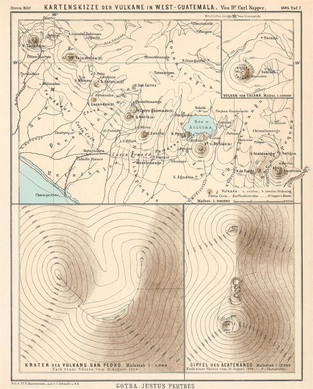
Kartenskizze der Vulkane in West-Guatemala.
1895 (dated) 9.75 x 7.75 in (24.765 x 19.685 cm) 1 : 900000
1895 (dated) 9.75 x 7.75 in (24.765 x 19.685 cm) 1 : 900000
Description
This is an 1895 Bruno Hassenstein map of volcanoes in western Guatemala. It depicts western Guatemala from the Tacaná Volcano on the Guatemala-Mexico border to Amatitlán and Lake Amatitlán, numerous volcanoes are illustrated and labeled, including the Volcán de Agua, the Volcán de Fuego, and the Volcán de Santa Maria. Cities and towns throughout the region are also labeled, along with rivers and the Lago de Atitlán. A dashed line marks the route followed by Dr. Sapper through the region. Topography lines are also illustrated, allowing the viewer some idea of the very mountainous nature of the terrain. An inset map situated in the upper right corner details the region around the Volcán de Tacaná, and labels both the town of Tacaná and Sabinal. Two other insets along the bottom focus on the Volcán San Pedro and the peak of the Volcán Acatenango.
Volcanoes in Guatemala
As is evident from the map, a chain of volcanoes, both active and dormant, occupies a northwesterly position in western Guatemala. Thirty-seven volcanoes are spread out across the country, three of which are categorized as currently active: Pacaya (which is not illustrated here – it is situated just off the right side of the map), Fuego, and Santiaguito. Many others, including Acatenango, Santa Maria, Agua, and Atitlán are not fully active or dormant. Two of Guatemala's volcanoes are also the tallest peaks in Central America: Tacaná and Tajumulco.Dr. Karl Sapper
Dr. Karl Theodor Sapper (February 6, 1866 - March 29, 1945) was a German explorer, linguist, traveler, and antiquarian known for his studies of the natural history, languages, and cultures of Central America at the turn of the 20th century. Between 1888 and 1895, Sapper traveled throughout Central America and over the course of his explorations published scientific works on an astounding array of subjects, including Mesoamerican languages, volcanology, and maps of Maya archaeological sites.Publication History and Census
This map was created and drawn by Bruno Hassenstein, engraved by C. Schmidt, and published by Justus Perthes in an 1895 edition of Dr. A. Petermann's Mitteilungen aus Justus Perthes' Geographischer Anstalt. The OCLC records examples as being part of the institutional collections at the University of Chicago, the University of Oxford, the Bavarian State Library, and The British Library.CartographerS
Bruno Hassenstein (November 23, 1839 - August 27, 1902) was a German cartographer and was born in Ruhla, Thuringia. In 1854, Hassenstein began studying cartography and working under August Petermann in Gotha, founder of Petermanns Geographische Mitteilungen. Over the ensuing years, Hassenstein drew numerous maps for Petermanns Geographische Mitteilungen before relocating to Berlin in 1866 to work for another cartographer, including Karl Klaus von der Decken. He returned to Gotha two years later and works on maps for Henrich Theodor Menke's edition of Spurner's atlas of medieval history. He became editor of the cartography section of the Mittellungen in 1878 and worked on the Atlas von Japan, which was published in 1885. The University of Göttingen awarded him an honorary doctorate in 1878. More by this mapmaker...
Johan Georg Justus Perthes (September 11, 1749 - May 2, 1816) was one of the most important German cartographic engravers of the 19th century. He was born in the Thuringian town of Rudolstadt, the son of a court physician. In 1778, he began working as a bookseller in Gotha. Perthes began his publishing empire shortly thereafter with the 1784 issue of the famed survey of European nobility known as the Almanac de Gotha. In the next year, 1785, he founded the cartographic firm of Justus Perthes Geographische Anstalt Gotha. His son Wilhelm Perthes (1793 - 1853) joined the firm in 1814. Wilhelm had prior publishing experience at the firm of Justus Perthes' nephew, Friedrich Christoph Perthes, who ran a publishing house in Hamburg. After Justus Perthes died in 1816, Wilhelm took charge and laid the groundwork for the firm to become a cartographic publishing titan. From 1817 to 1890. the Perthes firm issued thousands of maps and more than 20 different atlases. Along with the visionary editors Hermann Berghaus (1797 - 1884), Adolph Stieler (1775 - 1836), and Karl Spruner (1803 - 1892), the Perthes firm pioneered the Hand Atlas. When Wilhelm retired, management of the firm passed to his son, Bernhardt Wilhelm Perthes (1821 – 1857). Bernhardt brought on the cartographic geniuses August Heinrich Peterman (1822 - 1878) and Bruno Hassenstein (1839 - 1902). The firm was subsequently passed to a fourth generation in the form of Berhanrd Perthes (1858 – 1919), Bernhard Wilhelm's son. The firm continued in the family until 1953 when, being in East Germany, it was nationalized and run as a state-owned enterprise as VEB Hermann Haack Geographisch-Kartographische Anstalt Gotha. The Justus family, led by Joachim Justus Perthes and his son Wolf-Jürgen Perthes, relocated to Darmstadt where they founded the Justus Perthes Geographische Verlagsanstalt Darmstadt. Learn More...
August Heinrich Petermann (1822 - 1878) was a German cartographer. Petermann attended the 'Geographische Kuntschule' (Geographica School of Art), which was started by Heinrich Berghaus with the support of Alexander von Humboldt, in Potsdam beginning in 1839. Students at the school were obliged to work on many of the school's contracts, including maps for several different atlases. Following his time in Potsdam, Petermann relocated to Edinburgh and London from 1845 to 1854, where he gained insight into the commercial aspects of the cartography business. In 1854, Petermann returned to Gotha, Germany and began working with the Perthes brothers publishers. While working with the Perthes brothers, Petermann founded the journal Petermanns Geographische Mitteilungen, published from 1855 until 2014, long one of the most prominent German-language geography journals. Learn More...
Condition
Very good. Even overall toning. Very close bottom margin. Blank on verso.
References
OCLC 166100040.