Digital Image: 1844 Missionary Double Hemisphere Pictorial Map of the World
Weltkarte-missionsanstaltbasel-1844_d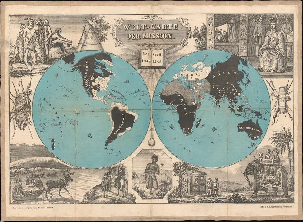

Title
Welt-Karte der Mission.
1844 (undated) 14 x 19 in (35.56 x 48.26 cm)
1844 (undated) 14 x 19 in (35.56 x 48.26 cm)
Description
FOR THE ORIGINAL ANTIQUE MAP, WITH HISTORICAL ANALYSIS, CLICK HERE.
Digital Map Information
Geographicus maintains an archive of high-resolution rare map scans. We scan our maps at 300 DPI or higher, with newer images being 600 DPI, (either TIFF or JPEG, depending on when the scan was done) which is most cases in suitable for enlargement and printing.
Delivery
Once you purchase our digital scan service, you will receive a download link via email - usually within seconds. Digital orders are delivered as ZIP files, an industry standard file compression protocol that any computer should be able to unpack. Some of our files are very large, and can take some time to download. Most files are saved into your computer's 'Downloads' folder. All delivery is electronic. No physical product is shipped.
Credit and Scope of Use
You can use your digial image any way you want! Our digital images are unrestricted by copyright and can be used, modified, and published freely. The textual description that accompanies the original antique map is not included in the sale of digital images and remains protected by copyright. That said, we put significant care and effort into scanning and editing these maps, and we’d appreciate a credit when possible. Should you wish to credit us, please use the following credit line:
Courtesy of Geographicus Rare Antique Maps (https://www.geographicus.com).
How Large Can I Print?
In general, at 300 DPI, you should at least be able to double the size of the actual image, more so with our 600 DPI images. So, if the original was 10 x 12 inches, you can print at 20 x 24 inches, without quality loss. If your display requirements can accommodate some loss in image quality, you can make it even larger. That being said, no quality of scan will allow you to blow up at 10 x 12 inch map to wall size without significant quality loss. For more information, it is best consult a printer or reprographics specialist.
Refunds
If the high resolution image you ordered is unavailable, we will fully refund your purchase. Otherwise, digital images scans are a service, not a tangible product, and cannot be returned or refunded once the download link is used.
Cartographer
Missions-Anstalt Basel (1815 - 2001) was a Protestant non-denominational missionary society based in Basel, Switzerland. It was founded in 1815 after Calvinists, and Lutherans from Württemberg swore a holy oath to form a joint seminary school, eventually establishing the Basel Mission (initially founded as the German Missionary Society). In addition to local and German missionaries, the school trained prospects from Britain and the Netherlands. During its almost two centuries, the Basel Mission was active in Russia, India, China, Borneo, Cameroon, Ghana, Nigeria, Sudan, and Latin America. In 2001, the Basel Mission was subsumed under Mission 21, the new and largest multi-denominational missionary organization in Switzerland. More by this mapmaker...
Godefroy Engelmann (August 17, 1788 – April 25, 1839) was a Franco-German lithographer and chromolithographer. Englemann was born in Mühlhausen, a small town near the France/Switzerland/Germany border. At the time of his birth Mühlhausen was a free German republic associated with the Swiss Confederation, but was annexed by France 10 years later. He trained in Switzerland and France, where he studied painting and sketching. In 1814 he travelled to Munich, Germany to study lithography under its inventor, Johann Alois Senefelder ( 1771 - 1834). The following spring, he founded La Société Lithotypique de Mulhouse. In June 1816 he opened a workshop in Paris. Engelmann is largely credited with bringing lithography to France, and commercializing chromolithography - a technique for which he was granted an English Patent in 1837. He died in 1839 in Mühlhausen, the town where he was born, of a neck tumor. Learn More...
References
OCLC 222378511. Cornell University Library, P.J. Mode collection of persuasive cartography, #8548 (1860 edition).