1875 Forrest Map of the West Australian Exploring Expedition
WestAustraliaExpedition-forrest-1875$850.00


Title
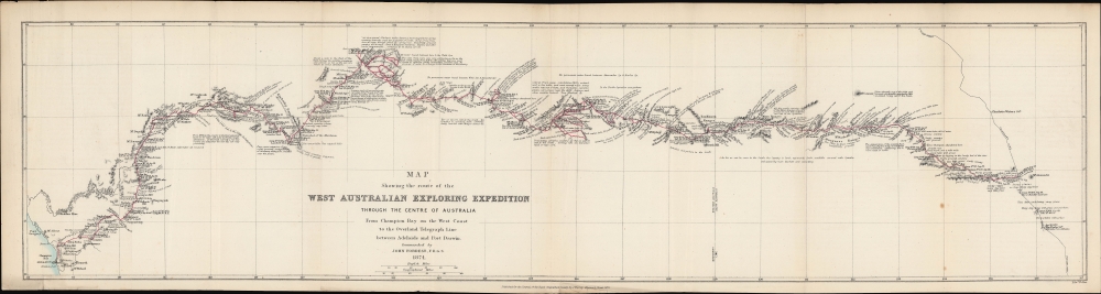
Map showing the route of the West Australian Exploring Expedition through the centre of Australia from Champion Bay on the west coast to the Overland Telegraph Line between Adelaide and Port Darwin.
1875 (dated) 7.5 x 30.25 in (19.05 x 76.835 cm) 1 : 3000000
1875 (dated) 7.5 x 30.25 in (19.05 x 76.835 cm) 1 : 3000000
Description
An 1875 map prepared by John Forrest, head of the Western Australia Exploring Expedition. It traces the progress and discoveries of the first extensive exploration of Western Australia's interior.
Traveling with a team of six, including his brother Alexander and a well-regarded indigenous guide named Tommy Windich, Forrest's group set out from Geraldton on Champion Bay on April 1, 1874. Over the next six months, the team battled the elements, particularly the lack of drinking water, scurvy, and an altercation with the local Martukaja (Mardu) people near Weld Springs, while they traversed hundreds of miles of previously uncharted territory. At several points, the expedition's members suspected they would not survive. But on September 27, the group reached the telegraph line from Adelaide to Darwin. Forrest's expedition was a remarkable success, gaining him public accolades and launching his political career, but the experience was so harrowing that it convinced Forrest that much of Western Australia was nearly uninhabitable and impossible for non-Aborigines to settle.
A Closer Look
Spanning a large section of Western Australia and Southern Australia, the map traces the expedition's progress in mid-late 1874. Beginning at Geraldton on Champion Bay, Forrest and his men traveled northeast along known waterways before cutting eastwards towards their goal, the telegraph line running north-south across the continent connecting Adelaide and Darwin. The locations and dates of the expedition's camps are recorded, along with copious notes on the terrain, water sources (if any), flora, and other details necessary for navigation and survival. Mountains, waterways, and other topographic details are illustrated throughout. The route of the expedition is prominently traced in red.Western Australia Exploring Expedition
Although by the mid-19th century, white British-descended settlers were well established along Australia's coasts, the vast and often inhospitable interior, particularly its western half, remained a mystery, inhabited by a range of Aboriginal groups. In the 1860s, several European explorers dared to penetrate the interior, but either made limited progress or disappeared and were presumed dead. It was, therefore, audacious and even reckless for Forrest to propose a trek through hundreds of miles of unknown arid territory only sparsely populated by Aborigines who might be hostile. But Forrest's familiarity with Australia's southwest, his previous field experience as a surveyor, and his success leading two earlier treks (less ambitious than the third but still impressive in their own right) made him the ideal head of such an effort.Traveling with a team of six, including his brother Alexander and a well-regarded indigenous guide named Tommy Windich, Forrest's group set out from Geraldton on Champion Bay on April 1, 1874. Over the next six months, the team battled the elements, particularly the lack of drinking water, scurvy, and an altercation with the local Martukaja (Mardu) people near Weld Springs, while they traversed hundreds of miles of previously uncharted territory. At several points, the expedition's members suspected they would not survive. But on September 27, the group reached the telegraph line from Adelaide to Darwin. Forrest's expedition was a remarkable success, gaining him public accolades and launching his political career, but the experience was so harrowing that it convinced Forrest that much of Western Australia was nearly uninhabitable and impossible for non-Aborigines to settle.
Publication History and Census
This map was drawn by John Forrest in 1874, and afterward was prepared as a lithograph by Edward Weller and published by John Murray in the 1875 Journal of the Royal Geographical Society of London, accompanying an article by Forrest recounting the expedition. The map is only independently cataloged by the National Library of Australia, while the entire 1875 volume of the journal is more widely distributed.CartographerS
Sir John Forrest (August 22, 1847 - September 2, 1918) was an Australian surveyor and politician who was instrumental to the surveying of Western Australia. Forrest was born in Bunbury to Scottish parents who were among the first settlers of Australind. After being educated in Perth, at age 16 he began an apprenticeship with Thomas Carey, a government surveyor based in Bunbury, from whom he also learned skills for surviving in the bush. Two years later, Forrest became a government surveyor in his own right, spending long periods in the field. Between 1869 and 1874, Forrest led three expeditions into the mostly uncharted lands of Western Australia, the last of which gained him considerable attention and praise. In 1883, he became Surveyor-General of Western Australia and Commissioner of Crown Lands, a more powerful position than the title might imply. He also entered politics, joining the Western Australia Legislative Council, which became the Western Australia Legislative Assembly when the colony was granted self-rule in 1890. The same year, Forrest was appointed the first Premier of Western Australia. His background in surveying likely inclined him towards supporting public works such as dams and railways, which characterized his time in office, along with greatly expanding the franchise to all adult men. He also represented Western Australia during talks over Australian federation and helped to shape the new constitution. He then served in the Australian House of Representatives and held several leadership positions in government over the next 15 years. John Forrest's younger brothers Alexander and David followed in his footsteps, training as surveyors, helping map Western Australia, and then entering politics. More by this mapmaker...
Edward Weller (July 1, 1819 - 1884) was a cartographer and engraver based in London. Weller was a nephew of another well-known map publisher Sidney Hall (1788 - 1831), who gave him 50 Pounds to pay his apprenticeship fees. He engraved for many prominent mapmakers and was active enough in the community to be recommended for membership to the Royal Geographical Society in 1851 on the recommendation of John Arrowsmith, among others. He eventually inherited the Sidney Hall map business which led him to follow Arrowsmith as the unofficial geographer to the Royal Geographical Society. Weller was among the first map printers in London to embrace lithography. His best known work appears in Cassell's Weekly Dispatch Atlas, published in monthly segments for subscribers of the 'Weekly Dispatch' newspaper. This collection of maps eventually grew to include much of the known world. Published in various editions from 1855 through the early 1880s. Weller died in May of 1884, leaving behind a successful business and an unhappy widow. His son, Francis Sidney Weller (1849 - 1910), followed in his father's footsteps and continued the family map business. The atlas Mackenzie's Comprehensive Gazetteer of England and Wales was published in 1894 and bore F. S. Weller's signature on the maps. Learn More...
John Murray I (1737 - 1793) founded the British publishing firm John Murray (1768 - present) in London. Born in Edinburgh, Murray served as an officer in the Royal Marines and built a list of authors that included Isaac D’Israeli and published the English Review. Murray the elder also was one of the founding sponsors of the London evening newspaper The Star in 1788. John Murray II (November 27 1778 - June 27, 1843) continued the family publishing business and developed it into one of the most important and influential publishing houses in Britain. The list of authors published by the firm grew to include Jane Austen, Sir Walter Scott, Washington Irving, George Crabbe, and Lord Byron under his tenure. Murray II also moved the business to 50 Albermarle Street in Mayfair, which became famous for Murray’s tradition of ‘four o’clock friends’, which was afternoon tea with his writers. John Murray III (1808 - 1892) continued to grow the business, and the firm published the first English translation of Goethe’s Theory of Colours, David Livingstone’s Missionary Travels and Charles Darwin’s Origin of Species during his tenure. Murray also published Herman Melville’s first two books. The firm began publishing Murray Handbooks in 1836, an ancestor of all modern travel guides. Sir John Murray IV (1851 - 1928) was publisher to Queen Victoria. Three successive Murray’s after Murray IV led the business until it was purchased by Hodder Headline in 2002, which was acquired by the French conglomerate Lagardère Group in 2004. Today, Murray is an imprint of Lagardère under the imprint Hachette UK. Learn More...
Royal Geographical Society (fl. 1830 - present) is a British Society established in 1830 to promote geographical science and exploration. Originally titled the "Geographical Society of London", the RGS received its royal charter from Queen Victoria in 1859 shortly after absorbing several similar but more regional societies including the African Association, the Raleigh Club and the Palestine Association. The RGS sponsored many of the most important and exciting voyages of exploration ever undertaken, including the exploration of Charles Darwin, David Livingstone, Robert Falcon Scott, Richard F. Burton, John Speke, George Hayward, H. M Stanley, Ernest Shackleton and Sir Edmond Hillary. Today, the RGS remains a leading global sponsor of geographical and scientific studies. The Society is based in Lowther Lodge, South Kensington, London. Learn More...
Source
Forest, J., 'Journal of the Western Australian Exploring Expedition through the Centre of Australia, from Champion Bay to the Overland Telegraph Line between Adelaide and Port Darwin ' The Journal of the Royal Geographic Society of London, Vol. 45 (London: John Murray, 1875).
Condition
Good. Light wear along original folds. Light soiling. Some discoloration and chips along edge.
References
OCLC 223107436.