This item has been sold, but you can get on the Waitlist to be notified if another example becomes available, or purchase a digital scan.
1872 Phillip King Admiralty Chart or Map of Western Australia (Perth)
WesternAustralia-king-1872$800.00


Title
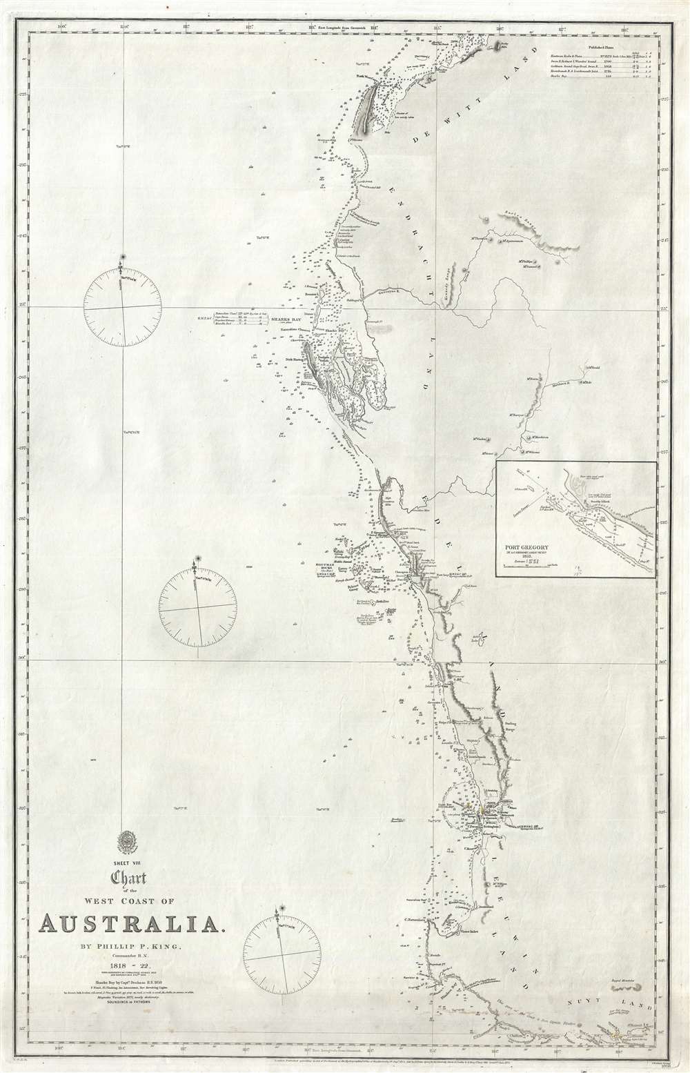
Sheet VIII Chart of the West Coast of Australia.
1872 (dated) 33 x 21 in (83.82 x 53.34 cm) 1 : 1900000
1872 (dated) 33 x 21 in (83.82 x 53.34 cm) 1 : 1900000
Description
An extremely rare 1872 British Admiralty nautical map of western Australia by Phillip Parker King. The map covers southwestern Australia roughly from Exmouth Gulf to modern-day Albany and the Point King Light, including the city of Perth. This chart constitutes a major chapter in the mapping of western Australia. It was originally surveyed by King between 1818 and 1822. King's mission was to fill in the gaps in explorations of Matthew Flinders. The present edition features updates by Commander John Lort Stokes (1842), John Septimus Roe (1855), and Captain Henry Mangles Denham (1859). The chart includes De Witt Land, Endracht Land, Edel land, Leeuwin Land, and Nuyt Land. The coasts of Nuyt and Leeuwin Lands are drawn from the work of Flinders with few updates. This edition of the map is notable for its inclusion of the 1859 mapping of Sharks Bay by Captain Henry Mangles Denham. Today Sharks Bay is a World Heritage site known for its Stromatolites, considered the oldest lifeforms on Earth. Despite many improvements, much of the coast, particularly north of Shark's Bay, remains only ghosted in and remained only tenuously known. Updates subsequent to 1859 are limited to magnetic variation.
Publication History
This map was printed by John Walker for the British Admiralty Hydrographic Office as chart number 1056. The original seller for this chart appears to have been J. D. Potter, of King Street, Tower Hill, London. It subsequently found its way to Melbourne, Australia, where it was sold by Blundell and Ford, Agents for the sale of Admiralty Charts. All examples of this chart in all editions are extremely rare. We have identified no other examples of the present 1872 edition. Two examples of the 1842 edition, after the Stokes updates, are known, one at the National Library of Australia, and another at the State Library of New South Wales.CartographerS
Admiral Phillip Parker King (December 13, 1791 - February 26, 1856) was an early explorer of the Australian and Patagonian coasts. Born on Norfolk Island of the coast of Australia, he was named after his father’s mentor Admiral Arthur Phillip, first governor of New South Wales and the founder of the British penal colony which became the city of Sydney in Australia). King was sent to England in 1796 for further education and he joined the Royal Naval Academy in 1802. He entered the navy in 1807 and was commissioned as a lieutenant in 1814. King was assigned to survey the unexplored portions of the coast of Australia and he made four voyages between December 1817 and April 1822. His main objective from the Admiralty was to try and locate a river which was 'likely to lead to an interior navigation into this great continent.' The Colonial Office also wanted information concerning topography, fauna, timber, minerals, climate, and the natives and the possibility of developing trade with them. King was promoted to commander in 1821 and returned to England in 1823. He was then given command of the HMS Adventure and sent on a five year survey expedition (1826 - 1830) of the coasts around Tierra del Fuego and the Straits of Magellan. King appears to have retired from active naval service sometime after this voyage, as the next reference is to entertaining Charles Darwin at his home in Sydney in 1836. King was appointed to the New South Wales Legislative Council in 1839 and as the resident commissioner of the Australian Agricultural Company that same year, a position he held for ten years. King was promoted to Rear Admiral on the retired list in 1855. More by this mapmaker...
The British Admiralty Office (1795 - Present) or the United Kingdom Hydrographic Office refers to the Branch of the English government that is responsible for the command of the British Navy. In 1795 King George III created the United Kingdom Hydrographic Office, known in short as the U.K.H.O., to provide top notch nautical charts to the vast Royal Navy. Prior the founding of the Admiralty the surveying and creation of nautical charts was primarily a commercial venture wherein the cartographer himself, more of than not, actually financed the printing of his own material. The great navigator Cook himself is known to have scrambled for funds to publish his own seminal charts - the most important and advanced of the period. The system of privately funded nautical mapping and publishing left vast portions of the world uncharted and many excellent charts unpublished. King George III, responding significant loss in trade revenue related to shipwrecks and delay due to poor charts, recognized the need for an institutionalized government sponsored cartographic agency - the Admiralty. The first head of the Admiralty, a position known as Hydrographer, was the important cartographer Alexander Dalrymple. Dalrymple started by organizing and cataloging obtainable charts before initiating the laborious process of updating them and filling in the blanks. The first official Admiralty Chart appeared in 1800 and detailed Quiberon Bay in Brittany. By 1808 the position of Hydrographer fell to Captain Thomas Hurd. Hurd advocated the sale of Admiralty charts to the general public and, by the time he retired in 1829, had issued and published some 736 charts. Stewardship of the organization then passed to Rear Admiral Sir Francis Beaufort. It was under Beaufort's administration that the Admiralty truly developed as a "chart making" as opposed to a "chart cataloging" institution. Beaufort held his post from 1829 to 1854. In his 25 years at the Admiralty Beaufort created nearly 1500 new charts and sponsored countless surveying and scientific expeditions - including the 1831 to 1836 voyage of the H.M.S. Beagle. By 1855 the Admiralty's chart catalog listed some 1,981 charts. Learn More...
John Walker (1787 - April 19, 1873) was a British map seller, engraver, lithographer, hydrographer, geographer, draughtsman, and publisher active in London during the 19th century. Walker published both nautical charts and geographical maps. His nautical work is particularly distinguished as he was an official hydrographer for the British East India Company, a position, incidentally, also held by his father of the same name. Walker's maps, mostly published after 1827, were primarily produced with his brothers Charles Walker and Alexander Walker under the imprint J. and C. Walker. Among their joint projects are more than 200 maps for the influential Society for the Diffusion of Useful Knowledge Atlas (SDUK). In addition they published numerous charts for James Horsburgh and the British Admiralty Hydrographic Office, including Belcher's important map of Hong Kong and Carless' exploratory map of Karachi. The J. and C. Walker firm continued to publish after both Walkers died in the 1870s. Learn More...
Condition
Very good. Some soiling at bottom.
References
National Library of Australia, 961974. OCLC 225446789. Perry, T. M. and Prescott, D. F. , A Guide to Maps of Australia in Books Published 1780 – 1830, 1825.A05.