1816 Thomson Map of the Western Hemisphere
WesternHemisphere-thomson-1815$350.00

Title
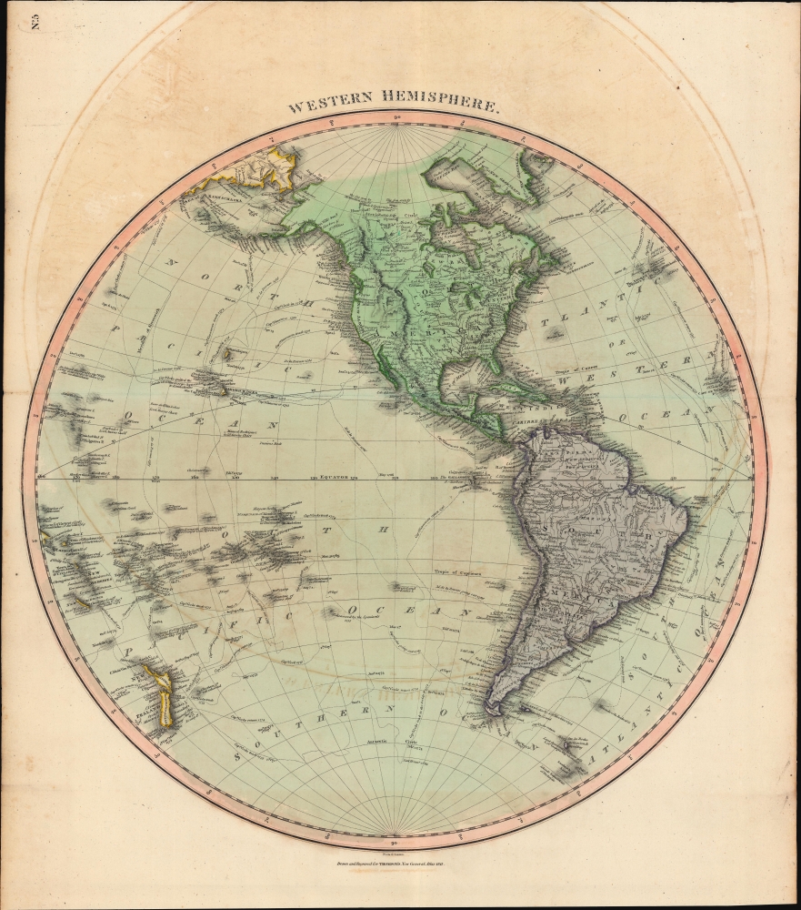
Western Hemisphere.
1815 (dated) 20.75 x 20 in (52.705 x 50.8 cm) 1 : 42000000
1815 (dated) 20.75 x 20 in (52.705 x 50.8 cm) 1 : 42000000
Description
A hand-colored 1815 map of the Western Hemisphere by John Thomson, which appeared in his New General Atlas. It is notable for tracing the routes of late 18th century explorers, including Cook, Vancouver, and La Perouse, that first gave shape, however inchoate, to the shores of northwestern America, Hawaii, New Zealand, and other Pacific coasts on European maps.
A Closer Look
Coverage includes North America and South America, or the Western Hemisphere, with cities, administrative divisions (including most U.S. states), rivers, mountains, and other features indicated. The approximate locations of some indigenous groups are labeled in the Americas. Significant attention is devoted to the Pacific Ocean to highlight the great voyages of exploration of the late 18th century, with the routes of Cook, Vancouver, La Perouse, and others traced, including the overland exploration of Mackenzie. The names of many islands in the Pacific here later took on different spellings (Oahu instead of 'Woahoo,' Tahiti instead of 'Otaheite') or different names altogether in Western languages.Publication History and Census
This map was prepared by John Thomson and engraved by Samuel Neele for Thomson's New General Atlas, 1817. Examples of the map display different pagination (or none at all) and other details depending on the printing. Thomson's maps are known for their stunning color, awe-inspiring size, and magnificent detail, resulting here in one of the finest maps of the Western Hemisphere to appear in the 19th century.CartographerS
John Thomson (1777 - c. 1841) was a Scottish cartographer, publisher, and bookbinder active in Edinburgh during the early part of the 19th century. Thomson apprenticed under Edinburgh bookbinder Robert Alison. After his apprenticeship, he briefly went into business with Abraham Thomson. Later, the two parted ways, John Thomson segueing into maps and Abraham Thomson taking over the bookbinding portion of the business. Thomson is generally one of the leading publishers in the Edinburgh school of cartography, which flourished from roughly 1800 to 1830. Thomson and his contemporaries (Pinkerton and Cary) redefined European cartography by abandoning typical 18th-century decorative elements such as elaborate title cartouches and fantastic beasts in favor of detail and accuracy. Thomson's principle works include Thomson's New General Atlas, published from 1814 to 1821, the New Classical and Historical Atlas of 1829, and his 1830 Atlas of Scotland. The Atlas of Scotland, a work of groundbreaking detail and dedication, would eventually bankrupt the Thomson firm in 1830, at which time their plates were sequestered by the court. The firm partially recovered in the subsequent year, allowing Thomson to reclaim his printing plates in 1831, but filed again for bankruptcy in 1835, at which time most of his printing plates were sold to A. K. Johnston and Company. There is some suggestion that he continued to work as a bookbinder until 1841. Today, Thomson maps are becoming increasingly rare as they are highly admired for their impressive size, vivid hand coloration, and superb detail. More by this mapmaker...
Samuel John Neele (July 29, 1758 - May 13, 1824) was a prolific British map engraver active in the late 18th and early 19th centuries. Neele apprenticed as a printer and engraver with Harry Ashby from about 1781 to 1782 before establishing himself independently in 1785 at 352 Strand, London. The combination of business acumen and technical skill made Neele extremely successful with literally hundreds of maps to his credit. His vast corpus was composed of notable maps by most major English publishers of the period including, Haywood, Faden, Wallis, Stockdale, Arrowsmith, Thomson, Pinkerton, and Greenwood, among others. Neele's sons, James and Josiah Neele, also engravers, took over their fathers business around 1818, both becoming notable in their own right. Learn More...
Source
Thomson, J., A New General Atlas, (Edinburgh) 1817.
Thomson's New General Atlas was first published in 1817 and continued to be published until about 1821. This is the first of Thomson's major cartographic works and the atlas for which is most celebrated. The New General Atlas follows in the Edinburgh School, which eschews excessive decoration in favor of a more minimalistic fact-based cartographic vision, as established by John Pinkerton, Laurie and Whittle, John Cary, and others in the previous decades. The maps are notable for their massive scale, heavy stock, elegant color work, and easy-to-read typefaces. Although the atlas stopped being published after 1821, Thomson continued to offer 'supplementary' maps that could be tipped into the atlas as late as 1830, when he declared bankruptcy. The maps in the Thomson Atlas were engraved by Thomas Clerk, William Dassauville, Nathaniel Rogers Hewitt, James Kirkwood, Robert Kirkwood, John Menzies, George Menzies, Edward Mitchell, John Moffatt, Samuel John Neele, Robert Scott, and James Wyld.
Condition
Very good. Light offsetting.
References
Rumsey 1007.006.