1873 Elias Map of Western Mongolia and northern China
WesternMongolia-elias-1873$800.00

Title
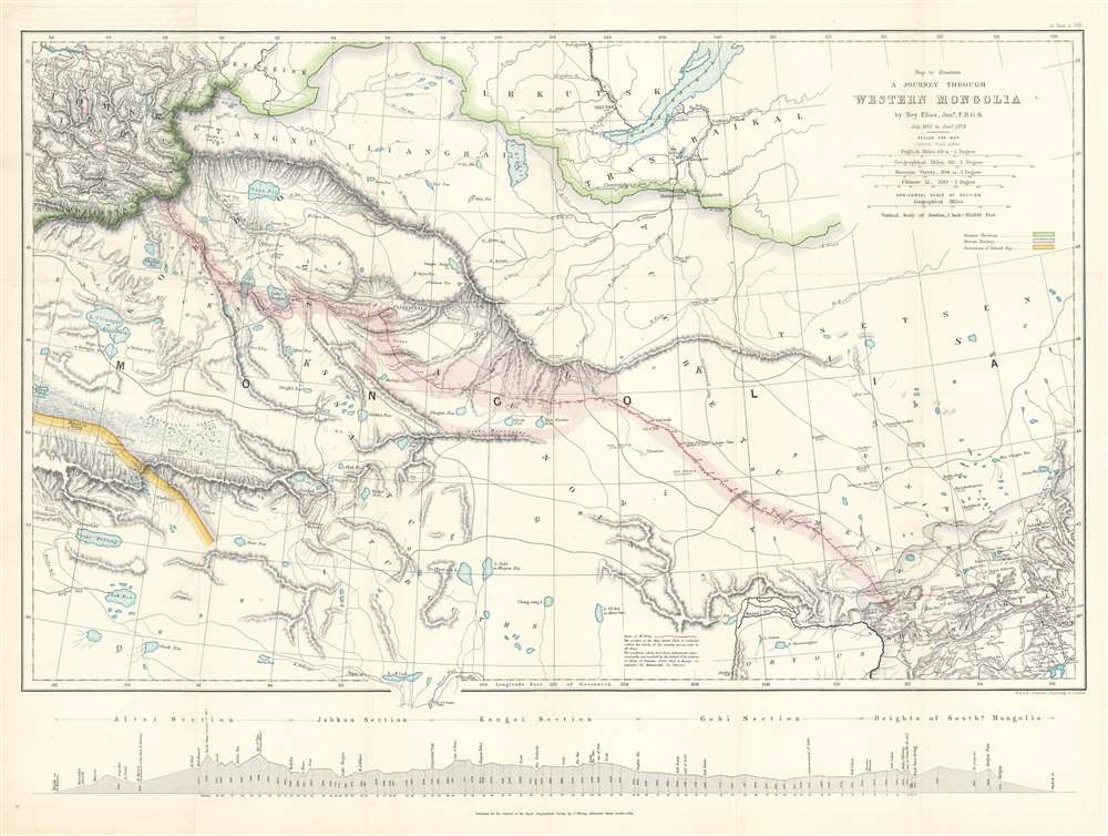
Map to illustrate A Journey Through Western Mongolia.
1873 (dated) 18.25 x 24.25 in (46.355 x 61.595 cm) 1 : 4320000
1873 (dated) 18.25 x 24.25 in (46.355 x 61.595 cm) 1 : 4320000
Description
This is an 1873 Ney Elias map of western Mongolia. Although not specifically described as such, this map and the Elias expedition were most likely British reconnaissance related to 'The Great Game'. This map was drawn by Elias after his 1872 expedition through the region. A thin red line follows his progress from Beijing (Peking), China, across the Gobi Desert to Bisk in Russia, where he arrived on January 4th, 1873. Elias marks each day's progress along his route and labels Uliassutai, the largest settlement he encountered. The pink shading around Elias's route highlights the limits of the surveys conducted by Elias during the expedition. Karakorum, which Elias refers to as the 'ancient Tartar capital', is marked in two places, suggesting ambugity over its actual location. The map traces the Great Wall along the bottom border, with the wall and the rivers leading from Lake Alak, Lake Tsui-yan, and Lake Sobi breaking the map's bottom border. Numerous lakes of varying sizes appear throughout.
The Expedition and the Survey
Elias left Beijing in July 1872 accompanied by a Chinese servant and traveled almost 2,500 miles across the Gobi Desert to the Russian border and then continued another 2,300 miles to Nizhny Novgorod. Along the way, he made astronomical measurements and other scientific observations. The locations of his readings are marked here with his initial (E). Other expedition routes are also traced, and geographical locations recorded by these individuals marked with their initials. A profile view of Elias's route appears along the bottom border.International Boundaries
Three international boundaries are delineated on the map using shading. Chinese territory, in the lower right corner, is shaded purple. Russian territory is marked by the green line along the top portion of the map, and the yellow on the lower right highlights 'Dominions of Yakoob Beg,' the Uzbek adventurer and ruler of Yettishar (Kashgaria). The white territory, through which Elias traveled, is disputed territory that had been overrun by the Tungani Rebels led by Yaqub Beg.Publication History and Census
This map was created by Ney Elias, engraved by the firm founded by William and Alexander Keith Johnston, and published by the Royal Geographical Society in 1873. An example is part of the collection at Princeton University. An empty OCLC reference exists for this map, suggesting that a former cooperative member created it.CartographerS
Ney Elias (Febraury 10, 1844 - May 31, 1897) was an English geographer, explorer, and diplomat. Born in Widmore, Kent, Elias was educated in London, Paris, and Dresden. He became a fellow of the Royal Geographical Society in 1865. He went to Shanghai as an employee of a mercantile house in 1866. In 1868, he volunteered to lead an expedition to examine the old and new courses of the Yellow River, which he recounted in a paper for the Royal Geographical Society. He left on his next expedition in July 1872, when he and a Chinese servant crossed the Gobi Desert, a distance of nearly 2,500 miles from the Great Wall to the Russian border. They then continued another 2,300 miles to Nizhny Novgorod. Elias chose to attempt such an undertaking during a particularly difficult time: that part of China was overrun by the Tungani rebels at the time, causing him weeks of sleepless nights and constant fear of attack. Apparently, when Elias finally reached the Russian frontier, the Russian border guards looked at him like he had just fallen from the sky. His geographical work in Mongolia earned him the Founder's Medal of the Royal Geographical Society in May 1873 and a job with the British colonial government in India. He was appointed assistant to the resident at Mandalay in September 1874 and shortly afterward was named second in command of an overland expedition to China. This expedition turned back after the murder of Augustus Raymond Margary. He was a member of Robert Shaw's cancelled expedition to Kashgar, and, already finding himself in Leh, stayed there as British joint-commissioner of Ladakh. On his own initiative, Elias went to Chinese Turkestan in 1879 and, narrowly avoiding 'serious misadventure' gained the official sanction of the Indian government and was assigned to 'special duty' in Yarkund, and Kashgar in 1879 and 1880, respectively, and against in 1885. From 1885 until his retirement in November 1896, Elias participated in numerous expeditions in Central Asia and greatly contributed to the geographical knowledge of the region. Elias died suddenly in London on May 31, 1897. He never married. More by this mapmaker...
Alexander Keith Johnston (December 28, 1804 - July 9, 1871) was a Scottish cartographer and map publisher active in the middle portion of the 19th century. Johnson was born at Kirkhill, near Edinburgh, Scotland. He studied at the University of Edinburgh where he apprenticed as an engraver. Around 1826, in partnership with his brother William, he founded a cartographic printing and engraving firm with the imprint "W. and A. K. Johnston." Johnston made a name for himself in educational geography, publishing numerous maps for use in schools. His brother, William Johnston, eventually left the firm to pursue a career in politics, eventually becoming the Lord Provost of Edinburgh. Alexander's son, who would bear the same name, became a geographer and explorer, suffering an untimely death on the Royal Geographical Society's 1879 expedition to Lake Nyasa. Learn More...
Royal Geographical Society (fl. 1830 - present) is a British Society established in 1830 to promote geographical science and exploration. Originally titled the "Geographical Society of London", the RGS received its royal charter from Queen Victoria in 1859 shortly after absorbing several similar but more regional societies including the African Association, the Raleigh Club and the Palestine Association. The RGS sponsored many of the most important and exciting voyages of exploration ever undertaken, including the exploration of Charles Darwin, David Livingstone, Robert Falcon Scott, Richard F. Burton, John Speke, George Hayward, H. M Stanley, Ernest Shackleton and Sir Edmond Hillary. Today, the RGS remains a leading global sponsor of geographical and scientific studies. The Society is based in Lowther Lodge, South Kensington, London. Learn More...
Source
Elias, N., 'Narrative of a Journey Through Western Mongolia, July 1872 - January 1873', The Journal of the Royal Geographical Society of London, Vol. 43. (London: Royal Geographical Society) 1873.
Condition
Very good. Exhibits light wear along original fold lines. Blank on verso.
References
Princeton University Library G7896.C1 1873 .R6. OCLC 642593023.