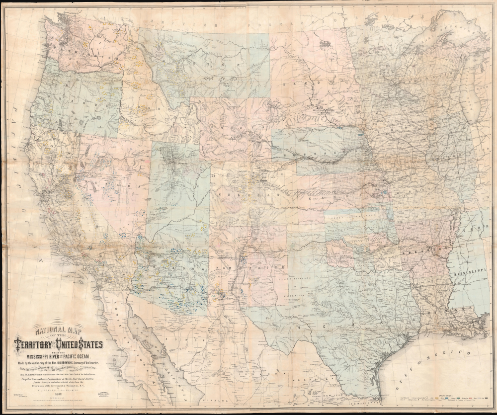
1867 Keeler Map of the Western United States (Minerals and Reservations)
WesternUnitedStates-keeler-1867-2$6,500.00


Title
National Map of the Territory of the United States From The Mississippi River To The Pacific Ocean.
1867 (dated) 47.5 x 57.5 in (120.65 x 146.05 cm) 1 : 2280960
1867 (dated) 47.5 x 57.5 in (120.65 x 146.05 cm) 1 : 2280960
Description
An extraordinary first-edition first-state example of William J. Keeler's seminal 1867 map of the Trans-Mississippi West - considered the finest post-Civil War railroad era map of the West. This is the true first edition, without American Indian reservations, which were added in subsequent editions issued within the same year.
What has been missed previously is that there are at least 3 variant states of the first edition, each readily differentiated by the progressive addition Indian Reservations. We have not studied this issue exhaustively, and there may well be additional variant states, and many other differences, but the three we have noted can be identified as follows:
A Monumental Map in Size and Importance
Keeler's map has been praised as 'the largest, finest and most detailed map of the West as it was then known' (Anderson Galleries). A civil engineer, Keeler compiled the map while working at the Department of the Interior under 'the authority of the Hon. O.H. Browning Secretary of the Interior in the Office of the Indian Bureau Chiefly for Government Purposes.' Taking advantage of the Department's cartographic holdings of unique survey work and unpublished railroad surveys, he was able to achieve there-to-fore unprecedented detail and accuracy. Despite the circumstances of its production, the publication itself was a private venture, financed by Keeler himself, with the intention to capitalize on renewed enthusiasm for western expansion after the end of the Civil War.In Keeler's Own Words
The map depicts the country from just east of the Mississippi westward to the Pacific and from the Canadian border to southern Texas. An 1867 newspaper promotional for the map, likely penned by Keeler, summarizes its rich content, while pointing to its odd public-private character.This map was made by the authority of Hon. O. H. Browning, Secretary of the Interior, chiefly for government purposes…. It is a complete railroad map, the only one published which shows the whole of the great Pacific railroad routes, and their projections and branches, together with all other railroads in the States and Territories bordering on the Mississippi on both sides; showing at a glance the eastern connections of those Pacific roads with the existing railroad systems of the country. It shows the township and range lines of all public land surveys up to date; all Indian reservations, military posts, forts, and c. One important feature is the location of all the mineral lands in the States and Territories being given. In fact, it is just what every trade, traveler and business man of the West needs, and will prove invaluable to them. (Daily Kansas Tribune, Sept. 22 1867, p. 3)Certainly, he was correct, as no finer map of the American West then existed - it was the perfect tool for a government seeking to end the violent Indian Wars and administer a tentative, if one-sided, peace.
Publication History
Despite the map's astounding importance, it has received very little direct scholarship due to a lack of ancillary data and the elusiveness of Keeler himself. The present example is the first-state first-edition of Keeler's map. Most examples of the first edition were produced for presentation to government officials and other influential people. Seeking to further monetize the map, Keeler re-issued it in 1868 in two smaller editions, with coverage extended somewhat further to the east but with significant detail omitted, including the rectilinear surveys of the General Land Office.What has been missed previously is that there are at least 3 variant states of the first edition, each readily differentiated by the progressive addition Indian Reservations. We have not studied this issue exhaustively, and there may well be additional variant states, and many other differences, but the three we have noted can be identified as follows:
- 1st state: No Tabequache Utes Reservation in western Colorado (current example)
- 2nd state: Tabequache Utes Reservation added, but no Colorado River Reservation in western Arizona
- 3rd state: Colorado River Reservation added
CartographerS
William J. Keeler (fl. c. 1856 - 1868) was an American civil engineer active during the second half of the 19th century. He is an elusive figure, and little is known of his birth and death dates, places, or early education. He appears in 1856, already working as a civil Engineer in Buffalo with the Erie Canal. In 1862 he received a civilian appointment, and possibly a honorary military rank, to work as an engineer at the Washington Naval Yard. He may also have worked at the Naval Yard in New York (Brooklyn). He was decommissioned in 1864 or 1865, after which he traveled west where he is recorded as an engineer with the Leavenworth, Lawrence and for Gibson Railroad Company. In 1865 he is also mentioned as working with the Union Pacific. In 1866 he was the chief engineer of the Kansas and Nesho Valley Railroad. He appears to have been employed with the department of the Interior Indian Bureau in by 1866 and/or 1867. He released his National Map of The Territory of The United States from the Mississippi River to the Pacific Ocean, one of the most important maps of the American west to appear in the 19th century, 1867. Although based upon government and railroad surveys, the map was a private publication and went through several subsequent editions, reissues, reformatting, and republications. Following the publication of the 2nd edition in 1868, Keeler seems to disappear from all record. More by this mapmaker...
Nicholas Du Bois (January 25, 1823 - August 8, 1879) was an engineer and draughtsman in the Washington D.C. General Land Office. Du Bois was born in Great Bend, Pennsylvania. Little is known of his early education, but in the 1850 census, he appears as an 'engineer'. By 1862, he was a clerk at the General Land Office. Subsequent reports from 1864 name him a draughtsman. He drafted William Keeler's seminal 1867 National Map of the Territory of the United States from the Mississippi River to the Pacific Ocean. By 1873, he was listed as an 'Assistant Surveyor'. Du Bois died in Washington, D.C. in 1879. Learn More...
Joseph Francis Gedney (November 4, 1828 - October 5, 1903) was a French-English-American engraver, printer, and lithographer. Gedney was born in Le Havre, Seine-Maritime, France, to a distinguished British family of Lincolnshire. He emigrated to the United States as a child, arriving at age 2 in 1831, in the wake of his mother's untimely 1830 death. It is unclear where he studied engraving, but he established himself on Maryland Avenue in Washington, D.C. in 1854, opening an engraving establishment. During the American Civil War (1861 - 1865), he served in the Union Army under John Aaron Rawlins (1831 - 1869). He completed both private and government contracts, including engraving and printing William Keeler's seminal 1867 National Map of the Territory of the United States from the Mississippi River to the Pacific Ocean. Gedney went on to acquire several important government printing contracts, which he retained until his 1903 death. Learn More...
Condition
Good. Typical of this map, due to its size and paper quality, there are reinforcements and fill repairs on verso at some fold intersections. Wear on original fold lines. Some bulking to paper. Accompanies original binder, which has leather spine reinforcement.
References
OCLC 225197861. Rumsey 4640.001. Wheat, C. I., Mapping of the Transmississippi West, 1540 – 1861, 1170. A catalogue of The Everett D. Graff collection of Western Americana., 2281. Howes, W., U.S.iana (1650-1950): A Selective Bibliography in which are Described 11,620 Uncommon and Significant Books Relating to the Continental Portion of the United States, K22. The celebrated collection of Americana formed by the late Thomas Winthrop Streeter, 3077. Schulten, Susan, Mapping the Nation, p. 164. Martin, J., and Martin, R., Maps of Texas and the Southwest, 1513-1900, 47.