
1726 Herman Moll Map of the West Indies, Florida, Mexico, and the Caribbean

This item has been sold.
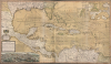
A Map of the West-Indies or the Islands of America in the North Sea; with ye adjacent Countries; explaining what belongs to Spain, England, France, Holland etc. also ye Trade Winds, and ye several Tracts made by ye Galeons and Flota from place to place. According to ye newest and most exact observations, by Herman Moll, Geographer.
Guide to the Golden Age of Piracy. Full old color.
- Digital Map Information
- Suitable for large format printing
- Full resolution TIFF file
- ICC color profile embedded
- Delivered instantly via download link
Guide to the Golden Age of Piracy. Full old color.
Published in 1726, this is an early printing of Herman Moll's superb map of the West Indies, Caribbean, Gulf of Mexico, Mexico, and the Spanish Main - with full old color. Monumental in proportion, rich in descriptive text, and exhaustive in its attention to detail, this map is best understood as a guide to English piracy and privateering in the West Indies. Moll, most likely through his acquaintance with pirates William Dampier and Woodes Rogers, offers a wealth of information on the traffic of silver bearing Spanish treasure fleets en route from the Mexican port of Veracruz, through the islands, to Spanish ports in Europe.A Closer Look
Moll's map spans from the north shores of South America to the Gulf Coast of North America, as well as the Atlantic coast as far north as 'Charles Town' in the Carolinas. In the west, Valladolid and Acapulco appear; the map reaches as far east as Surinam, thus embracing all the Caribbean and the West Indies. A bird's eye view of Mexico City occupies the lower left. In the upper right are inset charts of the harbors of St. Augustine, Veracruz, Havana, Portobello, and Cartagena.Moll traces the path of the famous Spanish treasure fleet's entrada into the Caribbean via the passage between Granada and Trinidad. The fleet then sailed westwards, skirting the Spanish Main until they reached Cartagena, where they rested and reprovisioned before heading northwards, rounding western Cuba and stopping in Havana. Using the strong Gulf Stream current - shown here - ships would sail northwards from Havana while being steadily forced to the southeast, thus alighting at the deep-water port of Veracruz. On the return, laden with silver from the mines of San Luis Potosí, the Spanish fleet took advantage of eastward blowing trade winds, which helped to overcome the strong current on the sail to Havana. From Havana, they would travel northwards via the narrow passage between Florida and the Bahamas before cutting eastward and out to sea at St. Augustine. It was here, in this crucial passage between the English-dominated Bahamas and Spanish Florida, that the most nefarious pirates lay in wait for their prey. As privateer fleets grew in strength and number in the early 18th century, full-scale assaults on major ports became increasingly common - notably targeting the five harbors charted in the insets. Moll's insets of these key treasure ports leave little doubt regarding his intentions and sources.
Moll further fills this marvelous map with annotations. He identifies, for example, the river route through Tabasco and Chiapas, via which supplies and cannons were transported to the important Pacific port of Acapulco. He also notes the Spanish fort of Pensacola, where 'all their Indians have Deserted and gone to ye French at Mobile.' Just to the east of this, in northern Florida, he identifies the land of the Apalache, once a powerful Indian empire which by Moll's time had all but vanished. This area was attacked and, according to Moll, 'brought over' to English rule by the governor of South Carolina, James Moore, in 1704.
In a few areas he also comments on some of the produce and mineral richness of the land, identifying the Silver Mines of Coahuila, the American Indian horseman of the Great Plains, Cacao Plantations in Costa Rica, sources of indigo, cochineal, and 'silvester' in the mountains of Guatemala, and the great number of 'Breeves' in Cuba and Texas. Breeves, curiously, were a kind of wild Spanish bovine that later evolved into the Texas Longhorn.
Cartographically, this map does offer a few interesting innovations. These include Moll's careful and accurate depiction of the Gulf Stream current as well as his orientation of Florida's St. John's River (St. Whan's R). This is the first map since the 16th-century Le Moyne map to correctly plot the St. John's River running south from its entrada north of St. Augustine. Earlier maps plotted the river running northwest into the great lake of Apalache - an error dating to Mercator's faulty 1608 mapping of the region.
In the lower left, there is a remarkable indexed view of Mexico City - then as now the largest city in the Americas. This view is derived from one originally composed in 1628 by Juan Gomez de Trasmonte. Trasmonte's view first appeared as part of an atlas prepared, but never published, by Dutchman Johannes Vingboons. Later, Montanus acquired the plates and published them in his own 1671 atlas. This is the first rendering of Mexico City to depart from the map view drawn under Cortez. An index of the view appears just above it and identifies many of the buildings still visible today in Mexico City's Zocalo and vicinity, including the Cathedral, the Palacio Real, Chapultepec, the Convento de San Francisco, and many others.
Publication History and Census
This map was engraved by Moll as a separate issue as early as 1710, as the British Museum dates it. Phillips dates the Library of Congress copy to 1715. It appeared bound first in Herman's Moll's 1719 folio New and Complete Atlas. Subsequent issues can be dated according to changes in the sellers' imprint. The present example, with the imprint 'Sold by H. Moll and by J. King at ye Globe in ye Poultry near Stocks Market', corresponds to those maps included in Moll's 1726 Atlas; those with the additional imprint of John and Thomas Bowles appear in 1732. The map, in its varied editions, is reasonably well represented in institutional collections; quality examples are increasingly difficult to find on the market.Cartographer
Herman Moll (1654 - 1732) was an important 18th century map publisher and engraver based in London and Holland. Moll's origins are disputed with some suggesting he was born in the Netherlands and others Germany - the Moll name was common in both countries during this period. Most likely Moll was a German from Bremen, as his will, friends, and contemporaries suggest. What is known for certain is that he moved to London in 1678, possibly fleeing the Scanian War, where he worked as an engraver for Moses Pitt and other London map publishers. Around the turn of the century, Moll set up his own shop where he produced a large corpus of work known for its high quality and decorative flair. As a new émigré to England, Moll made himself more English than the English, and through his cartography proved a fierce advocate for his adopted nation. Most of Moll's early maps were issued as loose sheets that would be bound to order, however, he did publish several important atlases late in his career. Moll is said to have made the bold claim that without a doubt "California is an Island" and that he "had in [his] office mariners who have sailed round it." While California may not be an island (yet), it is true that Moll had talent for attracting interesting friends and acquaintances. He frequented London's first stock exchange, Jonathan's Coffeehouse at Number 20 Exchange Alley, Cornhill. At the time Jonathan's was known as "a place of very considerable concourse for Merchants, sea faring Men and other traders" (Erleigh, The Viscount, The South Sea Bubble, Manchester: Peter Davies, Ltd., 1933, 21). Eventually this activity attracted the interest of stock brokers, who inspired by sailor's tales, sponsored the ill-fated South Sea Company, the world's first stock bubble. Moll's close circle, mostly from the Coffee House, included scientist Robert Hooke, the writers Daniel Defoe (Robinson Crusoe) and Jonathan Swift (Gulliver's Travels), the pirates William Dampier, William Hacke and Woodes Rogers, and the archeologist William Stukeley. Herman Moll's work was highly regarded for its decorative beauty and was pirated, most notably by the Irish publisher George Grierson, both in his lifetime and after his 1732 death at St. Clement Danes, London. Further Details...
Source
Moll, H., The World Described; or a New and Correct Sett of Maps, (London) 1726.
Herman Moll's The World Described; or a New and Correct Sett of Mapps Shewing the Several Empires, Kingdoms, Republics, Principalities, Provinces etc. in all Known Parts of the World is the most English atlas of the early 18th century, both for its cartographic content and for its unusual and evolving publication history. First issued c. 1715, the atlas was not conceived as a single, fixed-volume publication, but rather as a composite work assembled over time, reflecting the dynamic and commercial nature of the London map trade. Moll issued the atlas in parts, with new maps engraved, updated, and added incrementally across multiple printings extending to about 1754 (well after Moll's 1732 death). The earliest iterations of The World Described emerged during a period of intense interest in geography, trade, and imperial expansion. Moll capitalized on this demand by producing large, separately issued maps that could be sold individually or collected into bound atlases according to a purchaser's preference. As a result, no single 'standard' collation of the atlas; instead, surviving examples vary in content and arrangement. The maps themselves often bear the imprint 'Sold by H. Moll over against Devereux Court in the Strand,' and many are dated between roughly 1715 and the early 1720s, though dates are frequently absent, complicating bibliographic reconstruction. The World Described includes Moll's most influential maps, including large-format representations of North America, the Caribbean, and the British colonies. These maps are notable for their political and commercial emphasis, highlighting English territorial claims and trade routes. Moll's work also drew upon contemporary sources, including information from explorers, merchants, pirates, and private correspondents, lending the atlas both topical relevance and a degree of authority. Following Moll's death in 1732, the atlas passed into the hands of other London publishers, who continued to issue updates. Among these were Thomas Bowles, John Bowles, and later Robert Sayer. These publishers reissued Moll's plates, sometimes with updated imprints or minor revisions, extending the life of the atlas into the 1750s. There is also a famous pirated edition of The World Described issued in Dublin by George Grierson.
Condition
Good. Printed on two sheets joined as issued. Reinforced at folds. Some loss at bottom right fold, expertly reinstated. Bright, original outline color.
References
Rumsey 9729.012 (1732) Kagan, R.L., Urban Images of the Hispanic World, fig. 4.23 and fig. 6.1. Brown University, John Carter Brown Library, Z M726 1709-1 - 3-SIZE. Library of Congress, Map Division G4390 1715.M6 Vault. Phillips (Atlases) no. 554-10, 3469-10. Manasek, F. J., Collecting Old Maps, no. 69. Marshall, D. W., Research Catalog of Maps of America to 1860 in the William L. Clements Library, University of Michigan, Ann Arbor, Michigan, II-95-2-2. Library of Congress, A list of Books Relating to Cuba..., no. 1715. Phillips (America), v.1, no 13. Lowery, W., The Spanish Settlements Within the Present Limits of the United States, p. 392.