This item has been sold, but you can get on the Waitlist to be notified if another example becomes available, or purchase a digital scan.
1732 Herman Moll Map of the West Indies and Caribbean
WestIndies-moll-1732$325.00

Title
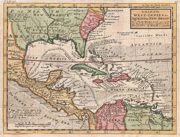
A Map of the West-Indies & c. Mexico or New Spain. Also ye Trade Winds, and ye Several Tracts made by ye Taleons and Flota from Place to Place.
1732 (undated) 8 x 11 in (20.32 x 27.94 cm)
1732 (undated) 8 x 11 in (20.32 x 27.94 cm)
Description
This is Herman Molls small but significant c. 1732 map of the West Indies. Moll's map covers all of the West Indies, eastern Mexico, all of Central America, the Gulf of Mexico, North America as far as the Chesapeake Bay, and the northern portion of South America, commonly called the Spanish Main. Typical of Moll's style this map offers a wealth of information including ocean currents and some very interesting commentary. Additionally Moll, most likely through his acquaintance with pirates William Dampier and Woodes Rogers, offers a wealth of information on the traffic of silver bearing Spanish treasure fleets en route from the Mexican port of Veracruz, through the islands, to Spanish ports in Europe.
Following the dotted line, Moll identifies the Spanish treasure fleet's entrada into the Caribbean via the passage between Granada and Trinidad. The fleet then sailed westwards, skirting the Spanish Main until they reached Cartagena, where they rested and reprovisioned before heading northwards, rounding western Cuba and stopping in Havana. Using the strong Gulf Stream current - shown here - ships would sail northwards from Havana while being steadily forced to the southeast thus alighting at the deep water port of Veracruz. On the return, laden with silver from the mines of San Luis Potosi, the Spanish fleet took advantage of eastward blowing trade winds, which helped to overcome the strong current on the sail to Havana. From Havana they would travel northwards via the narrow passage between Florida and the Bahamas before cutting eastward and out to sea at St. Augustine. It was here, in this crucial passage between the English dominated Bahamas and Spanish Florida, where the most nefarious pirates and British Privateers lay in wait for their profitable prey.
Moll further fills this marvelous map with numerous notations that, while bearing no direct impact on piracy in the region, do offer considerable insight into his political persuasions. He identifies, for example the river route through Tabasco and Chiapas, via which supplies and cannons were transported to the important Pacific port of Acapulco.
Moll also makes some interesting choices with regard to his mapping of the French territories in North America, namely New France and Louisiana. He firstly, in a nod to La Salle's colony of St. Louis, extends French control of Louisiana westward to the present day Texas-Mexico border of the Rio del Norte or, as it is known today the Rio Grande. He also includes Florida in the French regions – a very curious anti-Spanish stance. The North American British colonies including Carolina, Virginia, Georgia and Maryland are also noted.
This map was issued in a number of different states from 1729 to about 1750. Most commoly it appeared as plate no. 55 in Herman Moll and Thomas Bowles' Atlas Minor. This particular example was also issued in volume three of Samuel Simpson's The Agreeable Historian published in London in the 1740s.
CartographerS
Herman Moll (1654 - 1732) was an important 18th century map publisher and engraver based in London and Holland. Moll's origins are disputed with some suggesting he was born in the Netherlands and others Germany - the Moll name was common in both countries during this period. Most likely Moll was a German from Bremen, as his will, friends, and contemporaries suggest. What is known for certain is that he moved to London in 1678, possibly fleeing the Scanian War, where he worked as an engraver for Moses Pitt and other London map publishers. Around the turn of the century, Moll set up his own shop where he produced a large corpus of work known for its high quality and decorative flair. As a new émigré to England, Moll made himself more English than the English, and through his cartography proved a fierce advocate for his adopted nation. Most of Moll's early maps were issued as loose sheets that would be bound to order, however, he did publish several important atlases late in his career. Moll is said to have made the bold claim that without a doubt "California is an Island" and that he "had in [his] office mariners who have sailed round it." While California may not be an island (yet), it is true that moll had talent for attracting interesting friends and acquaintances. He frequented London's first stock exchange, Jonathan's Coffeehouse at Number 20 Exchange Alley, Cornhill. At the time Jonathan's was known as "a place of very considerable concourse for Merchants, sea faring Men and other traders" (Erleigh, The Viscount, The South Sea Bubble, Manchester: Peter Davies, Ltd., 1933, 21). Eventually this activity attracted the interest of stock brokers, who inspired by sailor's tales, sponsored the ill-fated South Sea Company, the world's first stock bubble. Moll's close circle, mostly from the Coffee House, included scientist Robert Hooke, the writers Daniel Defoe (Robinson Crusoe) and Jonathan Swift (Gulliver's Travels), the pirates William Dampier, William Hacke and Woodes Rogers, and the archeologist William Stukeley. Herman Moll's work was highly regarded for its decorative beauty and was pirated, most notably by the Irish publisher George Grierson, both in his lifetime and after his 1732 death at St. Clement Danes, London. More by this mapmaker...
The Bowles Family (fl. c. 1714 - 1832) were publishers and map sellers active in London from c. 1714 to c. 1832. The firm, under Thomas Bowles (fl. 1714 - 1763), John Bowles (1701 - 1779), Carrington Bowles (1724 - 1793), and as Bowles and Carver (fl. 1794 - 1832), produced a massive corpus of work that included numerous atlases, pocket maps, and wall maps. The Bowles publishing tradition was kept alive for four generations, starting with Thomas Bowles, a print engraver active in the late 17th century. His son, Thomas Bowles II, produced the firm's first maps at St. Paul's Churchyard, London. Thomas's brother, John Bowles (a.k.a. 'Old John Bowles' or 'Black Horse Bowles'), was also an active publisher established at no. 13 Cornhill. He is credited as one of the first publishers of William Hogarth's works. There, John's son, Carrington Bowles, was introduced to the trade. Carrington took over the Cornhill bookshop and eventually merged it with his uncle's shop in St. Paul's Churchyard. On Carrington's 1793 death, the business was passed to his son Henry Carrington Bowles (1763 - 1830), who partnered with his father's former apprentice Samuel Carver (1756 - 1841), renaming the firm 'Bowles and Carver'. Under this imprint, the firm continued to publish maps and atlases until 1832. Henry Carrington Bowles died in 1830, but Samuel Carver, himself in advanced years and poor health, kept it going for another 2 years before closing the business. Learn More...
Source
Moll, H., Atlas minor: or a new and curious set of sixty-two maps, in which are shewn all the empires, kingdoms, countries, states, in all the known parts of the earth; with their bounds, divisions, chief cities & towns, the whole composed & laid down agreable to modern history. By Herman Moll, Geographer, (Thos. and John Bowles, London) 1729 - 1736. ALSO IN: Simpson, S., The Agreeable Historian, (London) 1746.
Condition
Very good. Even overall toning. Blank on verso. Minor transferrence from adjacent page.
References
Rumsey 5580.055. Yale University, Beinecke Rare Book and Manuscript Library, E1015 M66 1732. Boston Public Library, Leventhal Map Collection, G4900 1732 .M65.