This item has been sold, but you can get on the Waitlist to be notified if another example becomes available, or purchase a digital scan.
1520 Apianus Cordiform Map of the World
World-apianus-1520$32,000.00

Title
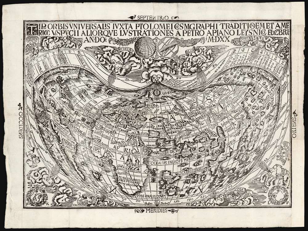
Tipus Orbis Universalis Iuxta Ptolomei Cosmographi Traditionem Et Americi Vespucii Aliorque Lustrationes A Petro Apiano Leysnico Elucbrat An. Do. MDXX.
1520 (dated) 11.75 x 16.5 in (29.845 x 41.91 cm)
1520 (dated) 11.75 x 16.5 in (29.845 x 41.91 cm)
Description
This is an attractive example of Petrus Apianus's 1520 map of the world, the earliest acquirable map to include the place name 'America.' In this respect it is pre-dated only by Waldseemüller's 1507 wall map, which exists in a sole surviving example held by the Library of Congress. Apianus was a well-respected and better-connected scholar, and in some respects his map's use of the name 'America' for the new world had broader impact even than the map on which the name first appeared. The map's projection and the lion's share of its geographical information derive from the 1507 Waldseemüller map of the world. In place of the hemisphere views present on the 1507 map, Apianus' displays in the upper decorative border an armillary sphere and a graticule, tools whose geometrical features allowed the composition of the map's projection.
Waldseemüller was reluctant to apply the name 'America' to the new discoveries, but his publishing partner Matthias Ringmann was a champion of Vespucci's claim for naming the new discoveries: and so the new map and the pamphlet accompanying it in 1507 would apply the name to the newfound continent. Waldseemüller would not repeat the act: his 1513 maps did not include this name. The influence of the 1507 world map was far-reaching, however, at least in part due to Apianus' use of Waldseemüller's work as a basis for the present map. Apianus's authority as an astronomer, and his enthusiastic support by Emperor Charles V meant that his adoption of the term 'America' would have disproportionate influence. The mapmaker Laurent Fries would use the name in his reduced edition of Waldseemüller's Ptolemy: he was a student of Apianus and he is believed to have been the formschneider for Apianus' map (his initials appear in the lower right hand corner of the map).
Given that both the Apianus and the Waldseemüller reveal a new continent distinct from Asia, it is perhaps fitting that they also support the use of Vespucci's name for the continent rather than that of Columbus: the latter, after all, to his death maintained that his discoveries were part of the East Indies, while Vespucci proposed that the new discoveries represented a new part of the world entirely.
Naming the New World
The first map to depict the new world, the 1506 Contarini, did not collectively name the new continent. The similar 1507 Ruysch world map used the term 'Novvus Mundus' but confined it to South America. Both presented the discoveries in Newfoundland and the maritimes of the Corte Real brothers as connected with the Asian mainland. Waldseemüller's 1507 wall map of the world would be the first to clearly depict North and South America as distinct from Asia.Waldseemüller was reluctant to apply the name 'America' to the new discoveries, but his publishing partner Matthias Ringmann was a champion of Vespucci's claim for naming the new discoveries: and so the new map and the pamphlet accompanying it in 1507 would apply the name to the newfound continent. Waldseemüller would not repeat the act: his 1513 maps did not include this name. The influence of the 1507 world map was far-reaching, however, at least in part due to Apianus' use of Waldseemüller's work as a basis for the present map. Apianus's authority as an astronomer, and his enthusiastic support by Emperor Charles V meant that his adoption of the term 'America' would have disproportionate influence. The mapmaker Laurent Fries would use the name in his reduced edition of Waldseemüller's Ptolemy: he was a student of Apianus and he is believed to have been the formschneider for Apianus' map (his initials appear in the lower right hand corner of the map).
Given that both the Apianus and the Waldseemüller reveal a new continent distinct from Asia, it is perhaps fitting that they also support the use of Vespucci's name for the continent rather than that of Columbus: the latter, after all, to his death maintained that his discoveries were part of the East Indies, while Vespucci proposed that the new discoveries represented a new part of the world entirely.
The Geography
Waldseemüller's, and in turn Apianus', treatment of Europe and Asia are largely drawn from Ptolemy. This is most broadly evident in the depiction of a shallow Indian Peninsula, a massive island of Taprobana, and the knobby shape of Aurea Chersonensus, corresponding with the Malay Peninsula. A prominent 'Dragon's Tail,' such as appeared on the 1490 Martellus map, shows the truncated land bridge thought by Ptolemy to have connected Africa with China - thus revealing the debt owed to Ptolemy, while acknowledging the more recent discoveries by the Portuguese that it was possible to sail around Africa to reach the Indies from Europe. Despite this revelation on the map, it does not reflect the Portuguese discoveries in India and the Far East that appear (for instance) on the Caveri or Cantino manuscripts which appear to have informed Waldseemüller's 1507 mapping of the Americas and Africa. The absence of this Portuguese information also removes Waldseemüller's 1516 Carta Marina as a possible source, as that map also replaces Ptolemy's Indian Ocean with that of the newer Portuguese discoveries.America and the Pacific
Apianus' treatment of America is modeled closely on that of Waldseemüller but differs in several astonishing ways. First, while the 1507 map does not depict the southernmost extent of South America, Apianus' map shows a distinct end to the continent permitting passage between the Atlantic and the Pacific Oceans. As with the Waldseemüller, there is a suggestion of coastline and even mountains along the Pacific coast of South America, in a clear indication of a postulated coastline. Apianus' map possesses a visual statement not present on the 1507 map emphasizing this: off the west coast of South America between the Tropic of Capricorn and the Equator is shown a fine, European-style sailing ship. This is an element which, on later sixteenth-century maps, is usually taken as a tribute to Magellan. Its appearance here is less easily explained. No ship announcing Magellan's successful passage to the Pacific would arrive in Europe until 1522. But Magellan had been petitioning the Portuguese king for support of his voyage as early as 1514. In 1518 Magellan won the support of the Spanish King Charles I (who would later become Charles V, Holy Roman Emperor.) Magellan left on his voyage in 1519. It is possible that Apianus, then a young scholar in Vienna, would have known of his new sovereign's support of the Magellan voyage and chose to allude to it in the body of his 1520 map. If this were a deliberate attempt to court the attention of the Emperor, it was perhaps fruitful: Apianus' academic career did come to Charles V's attention, to the extent that he would be made the Emperor's court cosmographer - accumulating titles to accompany his accolades.Publication History and Census
Apianus' map was first printed in 1520 for inclusion in Johann Kamers' edition of Solinus' Polyistōra, and would be included as well in Pomponius Mela's 1522 De Situ Orbis. The map is listed separately only at the Bibliothèque National de France.CartographerS
Petrus Apianus, or Peter Apian (April 16, 1495 – April 21, 1552) was a German humanist, astronomer, mathematician and professor who lived and worked in Ingolstadt and Vienna. He produced the most popular textbook on astronomy in the 16th century, the Cosmographicus Liber, and is known for his map of the world which until the rediscovery of Martin Waldseemüller's 1507 wall map was thought to be the first to use the place-name 'America.' His works were influential and were published in many languages, into the 17th century.
He was born as Peter Bienewitz in Saxony; his father, though not poor, was a Leisnig shoemaker. He gained an education and would between 1516 and 1519 study at the University of Leipzig. As is typical for academics of this era, he Latinized his name. The root of his German name, 'Biene,' is the word for 'bee;' hence, the Latin version of his name would be 'Apianus' (from the Latin 'Apis.' The humanists enjoyed word play.
From Leipzig, Apianus moved to Vienna to continue his studies. It was there that he would have encountered the monumental Waldseemüller map, which would inform his own 1520 map. Upon receiving his BA Apianus abandoned the plague-stricken Vienna for Landshut where he would produce his Cosmographicus liber in 1524. This, his magnum opus of astronomy and navigation, would be in print long after his death. Starting in 1527 he would operate a print shop in Ingolstatd, producing works contributing to the religious debates of his time, and printing many fine geographic and cartographic works. He came to the attention of emperor Charles V, whose admiration brought the scholar and printer a privilege in 1532 and 34; he would go on to become the emperor's court cosmographer and mathematician, a knight, and in time an Imperial Count Palatine. He married the daughter of a Landshut Councilman, and together they would have fourteen children. More by this mapmaker...
Martin Waldseemüller (September 11, 1470 - March 16, 1520) was a German cartographer, astronomer, and mathematician credited with creating, along with Matthias Ringmann, the first map to use the placename America. He was born in Wolfenweiler, near Freiburg im Breisgau. Waldseemüller studied at the University of Freiburg and, on April 25, 1507, became a member of the Gymnasium Vosagese at Saint-Dié. Martin Waldseemüller was a major proponent of theoretical or additive cartography. Unlike contemporary Portuguese and Spanish cartographers, who left maps blank where knowledge was lacking, Waldseemüller and his peers speculated based upon geographical theories to fill unknown parts of the map. He is best known for his Universalis Cosmographia a massive 12-part wall map of the world considered the first map to contain the name America, today dubbed as 'America's Birth Certificate'. This map also had significance on other levels, as it combined two previously unassociated geographical styles: Ptolemaic Cartography, based on an ancient Greek model, and the emergent 'carta marina', a type of map commonly used by European mariners in the late 15th and 16th centuries. It also extended the traditional Ptolemaic model westward to include the newly discovered continent of America, which Waldseemüller named after the person he considered most influential in its discovery, Amerigo Vespucci. When Waldseemüller died in 1520, he was a canon of the collegiate Church of Saint-Dié. In contemporary references his name is often Latinized as Martinus Ilacomylus, Ilacomilus, or Hylacomylus. Learn More...
Claudius Ptolemy (83 - 161 AD) is considered to be the father of cartography. A native of Alexandria living at the height of the Roman Empire, Ptolemy was renowned as a student of Astronomy and Geography. His work as an astronomer, as published in his Almagest, held considerable influence over western thought until Isaac Newton. His cartographic influence remains to this day. Ptolemy was the first to introduce projection techniques and to publish an atlas, the Geographiae. Ptolemy based his geographical and historical information on the "Geographiae" of Strabo, the cartographic materials assembled by Marinus of Tyre, and contemporary accounts provided by the many traders and navigators passing through Alexandria. Ptolemy's Geographiae was a groundbreaking achievement far in advance of any known pre-existent cartography, not for any accuracy in its data, but in his method. His projection of a conic portion of the globe on a grid, and his meticulous tabulation of the known cities and geographical features of his world, allowed scholars for the first time to produce a mathematical model of the world's surface. In this, Ptolemy's work provided the foundation for all mapmaking to follow. His errors in the estimation of the size of the globe (more than twenty percent too small) resulted in Columbus's fateful expedition to India in 1492.
Ptolemy's text was lost to Western Europe in the middle ages, but survived in the Arab world and was passed along to the Greek world. Although the original text almost certainly did not include maps, the instructions contained in the text of Ptolemy's Geographiae allowed the execution of such maps. When vellum and paper books became available, manuscript examples of Ptolemy began to include maps. The earliest known manuscript Geographias survive from the fourteenth century; of Ptolemies that have come down to us today are based upon the manuscript editions produced in the mid 15th century by Donnus Nicolaus Germanus, who provided the basis for all but one of the printed fifteenth century editions of the work. Learn More...
Lorenz Fries (c. 1490 – 1531) was a German cartographer, cosmographer, astrologer, and physician based in Strasbourg. Little is known of Fries' early life. He may have studied in Padua, Piacenza, Montpellier, and Vienna, but strong evidence of this is unfortunately lacking. The first recorded mention of Fries on a 1513 Nuremberg broadside. Fries settled in Strasbourg in March of 1519, where he developed a relationship with the St. Die scholars, including, among others, Walter Lud, Martin Ringmann, and Martin Waldseemüller. There, he also befriended the printer and publisher Johann Grüninger. Although his primary profession was as a doctor, from roughly 1520 to 1525, he worked closely with Grüninger as the geographic editor of various maps and atlases based upon the work of Martin Waldseemüller. Although his role is unclear, his first map seems to have been a 1520 reissue of Waldseemüller's world map of 1507. Around this time, Fries also began working on Grüninger's reissue of Waldseemüller's 1513 edition of Ptolemy's Geographie Opus Novissima. That edition included three new maps by Fries based upon the Waldseemüller world map of 1507 – two of these, his maps of East Asia and Southeast Asia, are quite significant as the first specific maps of these regions issued by a European publisher. In 1525, Fries decided to leave Strasbourg and surrendered his citizenship, relocating to Trier. In 1528, he moved to Basel. Afterward, he relocated to Metz where he most likely died. In addition to his cartographic work, Fries published tracts on medicine, religion, and astrology. Learn More...
Source
Solinus, Julius Caius, Polyhistor, (Vienna: Camertius) 1520.
Condition
Very good. Faint red ruling, some unobtrusive marginal mends, else excellent.
References
OCLC 494524224 Shirley, Rodney W., The Mapping of the World: Early Printed World Maps 1472-1700, 45. Nordenskiold, Facsimile Atlas pp. 6-7, 88, 99, 101, 112, pl.xxxvii; The World Encompassed: An Exhibition of the History of Maps Held at the Baltimore Museum of Art from October 7, 1952 to November 23, 1952 #61, pl.xxiii.