
1585 / 1592 Heinrich Bunting Woodcut Map of the World

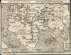
Cosmographia Universalis. / Wlastnj a oprawdowý spůsob wsseho okrsslku Země y Moře.
Rare Czech Edition.
- Digital Map Information
- Suitable for large format printing
- Full resolution TIFF file
- ICC color profile embedded
- Delivered instantly via download link
Rare Czech Edition.
This is Heinrich Bünting's 1585 map of the world, in its rare 1592 Czech edition. Bünting's more famous 'cloverleaf' world map was less a literal depiction of geography than an expression of patriotic devotion. (The cloverleaf was the sigil of his birth city, Hanover.) This map, which appeared in the same work, does represent an effort to show the actual shape and positions of the continents as they were understood in the early 16th century.A Beautiful and Entertaining Woodcut
Much of the map's charm lies in its apparent crudity. As with Bünting's other maps, and with earlier maps from the century, such as those of Münster, the purpose is not to provide fine detail but to communicate broad generalities. As such, the bold lines afforded by the woodcutters' art are more than adequate to present the simple map required. Mountainous regions and major cities are indicated pictorially; the oceans and seas are shown in wavy hachure. Three sea monsters prowl the Indian Ocean, while one appears in the Atlantic between Africa and the rudimentary America shown in the lower left corner.Geographical Scope
The map centers on Jerusalem and is dominated by Ptolemy's 'three parts of the world': Europe, Asia, and Africa. The form of the continents resembles that shown in maps fifty years prior - for example, the 1530 Lufft 'Daniel's Dream' map, or the Honter map of the same year. In many respects it even appears to be a simplified form of the 1513 Waldseemuller world map, sharing that map's focus on the old world, omission of the Pacific Ocean, and cursory representation of America. The decision to rely on such antiquated sources would be puzzling in the extreme - if the map was intended to do anything but fix Jerusalem and the Holy Land in context with Europe, Asia, and Africa. Bünting's Itinerarium Sacrae was a work of biblical geography. That said, any representation of the New World or the Pacific would be irrelevant here.India Meridionalis
Rodney Shirley's description of this map is unjustifiably dismissive, and his attention (like a hammer's fixation on nails) is only captured by apparent Australian geographical features:Part of what might well be mistaken for western Australia is placed in its correct position. It is, however, labeled India Meridionalis and can only be another instance of Bünting's strange geographical license.This is a puzzling statement, coming from a scholar so well-acquainted with the history of mapmaking - Bünting is merely relying on older geographical precedents here. Most world maps of the first part of the 16th century, among them Waldseemuller and Apianus, show a vast, inwardly curving peninsula extending from China and curving well south of the Malay Peninsula. On Bünting's map, much of this 'tail' has been truncated, leaving only the southern end visible, but its name - India Meridionalis, or 'Southern India,' indicates the connection to the rest of the continent. (Most of Asia was commonly termed India in early maps. India Intra Gangem refers to what we would normally think of as India, but India Extra Gangem - 'India beyond the Ganges' - refers to Burma and the Malay Peninsula. In this context, India Meridionalis indicates that the land shown was meant to connect with the rest of the continent to the north.
Publication History and Census
There were numerous editions of Bünting's Itinerarium produced in the 16th century alone, and at least three separate sets of blocks were executed to produce the maps for these. The typography of this example (particularly its Czech title and verso text) is consistent with the 1592 sole Prague edition of the Itinerarium. While the map has appeared on the market in its various states, this edition is rare, and we see no separate Czech examples of this map in OCLC. The Itinerarium totes Sacrae Scripturae appears in many editions in institutional collections overall, but only three of the 1592 Prague editions are indicated.Cartographer
Heinrich Bünting (1545 – 1606) was a Protestant pastor and theologian. He was born in Hanover, and studied theology at the University of Wittenberg. He earned his Master's degree in 1569. He remained in Wittenberg as a pastor there, before being appointed to that same position at Alt Calenberg, in the service of the Dukes of Saxony. The estate was dissolved when the marriage of the Duchess Sidona and Duke Eric the Younger foundered, and Bünting became pastor in Gronau in 1575. In Gronau, he wrote his two major works - the 1581 Itinerarium Sacrae Scripturae, and the 1584 Brunswick and Lüneburg Chronicle. He produced a smaller work on Biblical coins and measures in 1582. He would briefly serve as superintendent in Goslar, but he would be dismissed as a result of theological differences. Stung, he returned to his hometown and changed to the less controversial profession of a beer brewer, until his death in 1606. The work for which he is best known, Itinerarium Sacrae Scripturae, was the first complete summary of biblical geography. It remained in print in more than sixty editions, long after his death. Earlier editions contain some of the most distinctive and sought after maps, most notably his map of the world in the shape of a cloverleaf, and an allegorical map of Asia in the form of a Pegasus. Further Details...
Source
Bünting, Heinrich, Itinerarium Sacrae Scripturae, (Prague: M. Daniele Adama z Weleslawjna) 1592.
Condition
Good. Recornered at lower right, with area below text reinstated in facsimile. else very good.
References
cf. OCLC 164584511. Shirley 143.