
1880 Reza Persian City Map or Plan of Tabriz, Iran (Qajar Era)

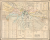
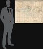
نقشه دارالسلطنه تبریز / [Map of Dār al-Salṭana (the Royal City) Tabriz].
First printed map of Tabriz.
- Digital Map Information
- Suitable for large format printing
- Full resolution TIFF file
- ICC color profile embedded
- Delivered instantly via download link
First printed map of Tabriz.
This rare 1880 Persian-language map of Tabriz, Iran, was prepared by engineer Mohammad Reza and military officer Colonel Qarajadāghī at the pioneering Tabriz Darulfunun (Tabriz State School). It is notable not only as one of the few surviving Persian-language maps from the 19th century and as the most detailed map of Tabriz at the time, but also for reflecting the situation of Tabriz and Qajar Iran. Located in the far northwest of Iran, Tabriz was on the front lines of a decades-long imperial tug-of-war between Qajar Iran, Tsarist Russia, and the Ottoman Empire. The city's proximity to Europe also supported a flourishing commercial economy and the early introduction of new technologies and practices, including recent developments in lithographic printing and scientific surveying.A Closer Look
This remarkable map shows the walled city of Tabriz at the center, with its hinterland divided by the Quri Chay ('Dry River') and an associated system of dikes and canals. Twenty different neighborhoods (محلهها) are color-shaded for easy distinction, as listed in the legend at the top-right. A wide variety of features of the urban landscape are indicated by symbols, also noted in the legend, including mosques, shrines, madrassas, bathhouses (hammams), ice houses (yakhchāls), caravanserais, bazaars, historical ruins, cemeteries, and, in the city's hinterland, orchards, gardens, and uncultivated lands. The map also records government, military, and industrial structures, the latter including kilns, mills, and workshops, reflecting the city's robust economy. The map contains considerable topographic detail, including contour lines (unusual for a non-Western map of the time) for the 'quarried mountains' (کوههای تراشیده) on the top-right.Many landmarks and important sites are labeled directly on the map. A collection of buildings near the center is the palace complex (Ali Qapu) of the Crown Princes, originally built in the Safavid era and elaborated by the Qajars, including royal gardens, the royal armory, and the royal women's quarters and harem. Military facilities such as gates in the city wall, barracks and dedicated stables, foundries, and bathhouses for troops are also labeled, many of them situated on the foundations of the city's citadel (ارگ). Religious, historic, and economic structures are similarly recorded, including the large bazaar complex spanning both banks of the Quri Chay, now a UNESCO World Heritage Site. 120 additional sites are numbered and listed in a thematic table at the bottom left. At the bottom, scale is indicated in zar' and qadam, two traditional Persian units of measurement. A qibla diagram is included nearby, pointing to the direction of Mecca from Tabriz.
Tabriz and the Tenuous Frontiers of Qajar Iran
Tabriz was an important political, economic, military, and cultural center during the Qajar Period (1789 - 1925), perhaps best known as the place of residence of Qajar crown princes (who also normally served as governors of Azerbaijan province). Indeed, Tabriz is thought to have been the most populous Persian city in the 19th century (likely over 150,000 residents at the time of publication), and certainly among the most prosperous, as it was a gateway for trade with Europe, including a trade route linking to Trabzon (Trebizond) on the Black Sea. Historically, the city's identity is closely tied to the Turkic world, despite being ruled as part of Persia since the early 16th century (and serving as the Safavids' capital early in their reign). As a conduit for trade, Tabriz also introduced Western technologies and practices to Persia, including lithographic printing and modern surveying techniques, as reflected on the present map.Moreover, Tabriz acted as a bulwark on Persia's frontier, especially after losing two successive conflicts against the Russians in the early 19th century, which resulted in the Russian occupation of the formerly Persian and Ottoman-ruled Caucasus. Tabriz itself was captured by Russian troops in October 1827 and occupied until Iran relinquished its remaining territory in the Caucasus. In the face of these setbacks, crown prince Abbas Mirza (1789 - 1833) sought to modernize Iran's military by learning the latest military techniques from captured Russian soldiers and deserters (some of whom, such as Samson Makintsev / Samson Khan, rose to be Qajar generals), and later by employing French and British officers who were veterans of the Napoleonic Wars. Modern polytechnic institutions were also established, namely the Tehran Darulfunun in 1851 and the Tabriz Darulfunun 25 years later, which taught modern surveying and military science. The result, seen here, is that foreign-trained Iranian engineers and military officers applied European surveying methods, such as incorporating astronomical coordinates, dual linear scales, and standardized symbols, to map strategic frontier regions and major royal centers like Tehran and Tabriz.
Publication History and Census
This map was drafted in 1880 by Mohammad Reza (محمدرضا مهندسی), the last part of his name being a title equivalent to 'engineer' or 'mathematician,' and one Colonel Qarajadāghī, presumably from the Qaradāgh or Arasbaran region in northwestern Iran. Much of the legwork on preparing the map was undertaken by Reza's students at 'the military college' in Tabriz, referring to Tabriz Darulfunun (Tabriz State School), founded in 1875 to teach a course of study in mathematics and military science. The map was prepared on the orders of the Crown Prince at the time, Muzaffar Mirza, who later ruled as Mozaffar ad-Din Shah (r. 1896 - 1907), and was overseen by Colonel Mirza Abbas Khan, who ran the 'military college' in Tabriz. It was printed at the Sacred Printing House (دارالطباعهٔ مقدس, so named because it initially almost exclusively printed religious works), an early state-affiliated lithographic printshop in Tabriz.An example of the map was later (1894) presented to the Royal Geographical Society by Albert Houtum-Schindler (1846 - 1916), who had a long career in Persia managing the country's telegraph network along with mines and banks, and was seemingly reproduced with the English title, 'Plan of Tabriz, from surveys by pupils of the Military College at Tabriz in 1880.' This 1880 original was also the basis for a 1908 map published by Edward Browne in French ('La carte de Tauris pendant la revolution. 27 Septembre'), issued at the height of the Persian Constitutional Revolution, in which Tabriz played a central role. The only known institutional holding is at the Royal Geographical Society, London.
Cartographer
Mohammad-Reza Mohandesi (محمدرضا مهندسی, Mohammad-Reza Mohandes, Mohammad-Mirza Mohandes; fl. c. 1880 - 1883) was an Iranian engineer and surveyor active in the late 19th century. He is best known for drafting, with one Colonel Qarajadāghī, an 1880 plan of Tabriz using modern surveying methods. Both Mohammed Reza and Qarajadāghī were affiliated with the military college of Tabriz when preparing the map, with Reza teaching mathematics at his alma mater and seemingly employing students in the preparation of the map. Afterwards, he was tasked with preparing a map of Seistan (Sistan) Province in eastern Iran in 1883 that also aimed to demarcate the border with Afghanistan. Further Details...
Condition
Very good. Printed on thin Iranian paper. Dissected and laid down on original linen. Some edge wear along old folds. Discoloration on left side, near center, at first fold intersection.
References
Royal Geographical Society Map Room, Iran G.26(66), Iran S.21. Alai, C., Special Maps of Persia 1477-1925, (Leiden: Brill) 2010, E. 631 (pp. 341 - 342). Werner, C., An Iranian Town in Transition: A Social and Economic History of the Elites of Tabriz, 1747-1848 (Weisbaden: Harrassowitz Verlag) 2000.