
1844 Mitsukuri Double Hemisphere World Map

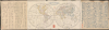
新製輿地全圖 / [Newly-Made Complete Map of the World].
One of the Most Influential Japanese Maps of the 19th Century. / Japanese recognition of the Sea of Korea.
- Digital Map Information
- Suitable for large format printing
- File Size: 30.62 MB
- File Type: ZIP / TIFF
- ICC color profile embedded
- Delivered instantly via download link
One of the Most Influential Japanese Maps of the 19th Century. / Japanese recognition of the Sea of Korea.
This is a fascinating 1844 Mitsukuri Shōgo double-hemisphere world map with descriptive text. Based on a somewhat earlier French map, it is important in the migration of Western geographic knowledge to Japan, even in the years before Japan was 'forced open' by American warships, hastening the end of its period of isolation. It is also unusual as one of the very few Japanese maps to recognize the 'Sea of Korea' toponym.A Closer Look
The map measures 13.25 x 23.75 inches, while the entire sheet spans 48.5 inches. The map presents the world divided into Western and Eastern Hemispheres. Countries, cities, and geographic features are labeled throughout, with the boundaries between countries outlined in hand-coloring. The geographic information is consistent with the source map's 1835 date, with Texas still part of Mexico. Other information reflects the latest discoveries as of the early 19th century, such as the Sandwich (Hawaiian) Islands and a full mapping of Australia and New Zealand, as well as many islands in the South Pacific.Additional information is provided in annotations, such as the explanation that the United States practices a republican form of government (共和政治). The large blocks of text to the left and right of the map discuss concepts such as latitude, longitude, the poles, different climatic zones, the representation of borders, and other editorial choices involved in producing the map. A legend appears at left, including abbreviations for major countries to indicate their colonies, such as イ for Spanish (伊斯把泥亞) colonies and エ for British (英吉利, adding a 口 radical to each character here) colonies. Kana is employed throughout the text and map to make the map more accessible to a Japanese audience that might have had limited understanding of kanji and of placenames outside of Japan.
Some of the terminology is curious, especially 'Sea of Korea' (朝鮮海) for the body of water between Japan and Korea (generally though inconsistently referred to as 'Sea of Japan' 日本海 on contemporary Japanese maps, while here the Pacific Ocean to the east of the Japanese archipelago is called the 'Great Sea of Japan' 大日本海). This terminology was presumably borrowed from the source map(s). Another interesting modification is the highly detailed coverage of Qing China, naming individual provinces, which would have been atypical (though not unheard of) for a Western-language double hemisphere world map of the time.
The Map's Influence
Mitsukuri's map was one of the most important of the late Edo period and exerted a deep influence on other Japanese intellectuals of the era. It is sometimes called the 'first Japanese world map,' meaning the first complete world map (reflecting the discoveries of Cook, Vancouver, La Perouse, et al) produced domestically in Japan, though it is likely that earlier maps represented these discoveries more vaguely. (It is difficult to say with certainty as many maps of this era are undated and unattributed; see, for example, our WorldJapanese-unknown-1840.) Nevertheless, there is little doubt that the present map is among the most influential world maps made in Japan in the late Tokugawa period, aided by Mitsukuri's status as one of Japan's preeminent Rangaku scholars.A Small Opening to the World
For most of the Edo or Tokugawa Era (1600 - 1868), Japan operated under Sakoku (鎖国, 'Locked Country') policies, where foreign trade and interaction were allowed with the Dutch and Chinese at Nagasaki and through other tightly constrained channels, but otherwise were forbidden to prevent potentially troublesome foreign ideas like Christianity from undermining Tokugawa rule. Nevertheless, some Japanese intellectuals, particularly of the 'Dutch Learning' (Rangaku) School, were aware of developments in the outside world, and the Tokugawa became quietly but increasingly concerned about foreign threats. Whalers, adventurers, and would-be traders from Russia, Europe, and the United States appeared on Japan's shores with increasing frequency at the end of the 18th century.In response, the Tokugawa moved to exert greater control over the northern region known as Ezo (蝦夷), including Hokkaido, through the Matsumae clan, vassals of the Tokugawa. Some intellectuals like Nagakubo Sekisui (長久保玄珠) and Mogami Tokunai (最上徳内) successfully advocated for new land surveys and the production of improved maps. But others, such as Hayashi Shihei (林子平), found that there were limits to acceptable public discussion of geographical knowledge, especially if it touched on politics and geopolitics, and were consequently censored. The distinction between acceptable distribution of knowledge and subversion was not always clear and subject to rapid change, often as a result of wider shifts in foreign policy. For instance, just before this map's publication, the bakufu, learning of China's drubbing at the hands of the British in the First Opium War (1839 - 1842), shifted to a more conciliatory approach towards foreigners washing up on Japan's shores, officially revoking the long-established (but not always enforced) edict to execute them on sight.
Although the Tokugawa continued to maintain Sakoku, among intellectuals who were aware of what had happened to China in the Opium War, were plugged into Rangaku circles and had some knowledge of advanced Western technology, and consumed works such as this map, there was a deep sense of foreboding about Japan's future.
Publication History and Census
This map was prepared by Mitsukuri Shōgo (箕作省吾), who signs (謹識) the text at left, and to whom the map is generally attributed. It was engraved by Takeguchi Teisai (竹口貞齋) and Sugita Yūsai (杉田祐齋). The text at right is signed by Ōtsuki Takashi (大槻崇) a nom de plume for Ōtsuki Bankei (大槻磐渓, see biography below). The map is dated 1844 (Tenpō 15 / Kōka gannen) and it was published in Mamasaka by Mukarō (夢霞樓), and, as explained in the text, it is based on an 1835 French map by an unnamed cartographer. Stylistically, the map resembles Felix Delamarche's Mappe-Monde ou Carte Générale du Globe Terrestre, though the hemispheres have been flipped here, but the detailed content exceeds that of Delmarche's and, as the accompanying text suggests, was compiled from multiple sources. The seal stamp at middle-top between the hemispheres (稟准刊行) means 'approved for publication', a reflection of the strict censorship regime still prevailing at the time.Establishing a census for this map is somewhat difficult as the title was used for several maps of the late Edo period; for example, the University of California Berkely holds a map with the same title and a similar text but with a different presentation and less specific publication information, including no date and no mention of Mitsukuri. Given the political and practical limitations on outside cartographic knowledge in Japan at the time, it is likely that this original 1844 map by Mitsukuri circulated in a semi-underground network among intellectuals and was modified in the course of being reprinted one or more times, in a cartographic game of telephone.
Nevertheless, as examples of this map are dated to 1844 and names Mitsukuri (as well as Ōtsuki, the engravers, and publisher), they can be readily distinguished from later imitations. The map is held by a handful of institutions in Japan, including the National Diet Library, Tokyo National Museum, and the Nichibunken (International Research Center for Japanese Studies), and outside of Japan by the University of California, Berkeley, Stanford University, Brigham Young University, and the University of Manchester.
Cartographers
Mitsukuri Shōgo (箕作省吾; 1821 - January 29, 1847) was a Japanese geographer of the late Edo / Tokugawa period. He was born into the family of a retainer of the Rusu Clan in Sendai Domain and his birth name was Sasaki Hiroshi. Mitsukuri was strongly influenced by the foreign influences present in Sendai at the time, studying Dutch Learning (Rangaku, i.e. Western Learning) and Chinese classics. Mitsukuri later continued his studies in Kyoto and Edo, focusing on Dutch Learning. During his travels, he also studied the customs, cultures, and topography of different parts of Japan. In Edo, he became a disciple of Mitsukuri Genpo (1799 - 1863), one of the leading Rangaku scholars of the time, from whom he took his name (he also married Mitsukuri Genpo's daughter). In addition to an influential 1844 world map (based on an 1835 French original), Mitsukuri also published books on geography and on 'Western affairs' that were influential on diplomats of the late Tokugawa period, as Japan desperately tried to adjust to a dangerous international environment. Further Details...
Ōtsuki Bankei (大槻盤渓; June 25, 1801 - June 13, 1878) was a draughtsman, painter, political figure, and leading Japanese Sinologist and expert on Confucianism in the late Tokugawa and early Meiji eras. His father was Ōtsuki Gentaku (大槻玄沢, 1757 - 1827), a feudal lord in Sendai Domain and a prominent Rangaku scholar. Legend holds that Ōtsuki Gentaku steered his son towards Sinology so that the works he had translated from Dutch into Japanese could then be translated into Classical Chinese, a form revered by Tokugawa Japan's intelligentsia, and thereby gain greater influence. Through his father's connections, at the age of 16, Ōtsuki Bankei began to study the Chinese Classics with Hayashi Jussai (1768 - 1841) and Matsuzaki Kōdō (1771 - 1844). He would continue his studies in the following years, both attending and teaching at the Sendai domain school of Yōkendō (養賢堂, which he would later head), a major center of Sinology and Confucian studies. When he was 27 years old, Ōtsuki undertook a long journey throughout Japan, eventually ending in Nagasaki to study Rangaku; he encountered many leading scholars along the way and wrote an account of his trip titled 'Journey to the West' (西遊紀程), a play on the name of the classical Chinese epic story. However, soon afterwards his father became ill and died, forcing Ōtsuki Bankei to return to Sendai, ending his flirtation with Rangaku. He then settled in Edo and focused on Sinology. However, during his brief stay in Nagasaki, he had encountered Takashima Shūhan (1798 - 1866), an early Japanese expert on modern Western artillery, and like Takashima became determined to domesticate this technology. By 1851, Ōtsuki was appointed Sendai's expert on Western artillery and shortly thereafter instructed to begin constructing his own canons. From 1849, Ōtsuki openly advocated opening the country, a still fairly scandalous position, and believed that Japan could use Russian influence to ward off American and British commercial dominance to avoid a fate similar to Qing China in the First Opium War (1839 - 1842). On both appearances of Perry's 'Black Ships' off Japan's shores, Ōtsuki advised that the Americans should be received peacefully and he penned a poem that impressed Luo Sen (1821 - 1899), Perry's Chinese interpreter. He also consulted with Yoshida Shōin (1830 - 1859) before the latter's failed attempt to stowaway aboard one of Perry's ships; Yoshida was said to be carrying a copy of an 1844 world map (新製輿地全圖) which Ōtsuki helped prepare when he was captured. Ōtsuki retuned to Sendai to serve as head of Yōkendō, but then became embroiled in the Boshin War between the 'restorationists' supporting the Meiji Emperor and those loyal to the Tokugawa. With the Tokugawa loyalists on the losing side of the conflict, Ōtsuki was imprisoned and many of his associates and students were executed. He himself was intended to be beheaded but was shown leniency given his scholarly status and advanced age. He was released from prison in 1870 and after a period of house arrest moved to Edo (now Tokyo) in 1871. He passed a quiet retirement in Tokyo, watching the monumental changes underway in Japan with keen interest, feeling vindicated in his earlier belief that the country needed to open to the West. Further Details...
Condition
Good. Some edge wear and repairs to edges and older wormholes. Panels added to left and right sides.
References
OCLC 1263253163, 1020881587. University of Manchester Japanese Maps Project, Japanese 118a.