This item has been sold, but you can get on the Waitlist to be notified if another example becomes available, or purchase a digital scan.
1658 Nicolas Visscher Double Hemisphere Map of the World
World-visscher-1658$5,000.00


Title
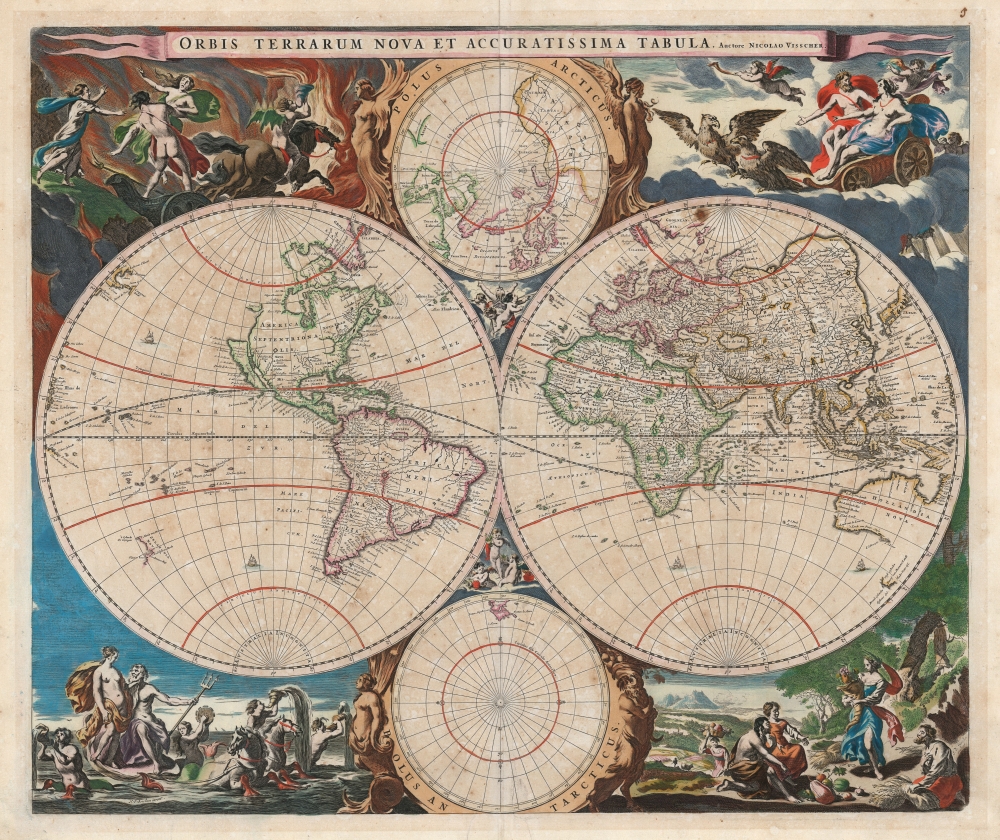
Orbis Terrarum Nova et Accuratissima Tabula. Auctore Nicolao Visscher.
1658 (undated) 18.25 x 22 in (46.355 x 55.88 cm) 1 : 90000000
1658 (undated) 18.25 x 22 in (46.355 x 55.88 cm) 1 : 90000000
Description
This is Nicolas Visscher's classic 1658 double hemisphere map of the world, in beautiful original color. It epitomizes, both aesthetically and geographically, the Dutch World map of the second part of the 17th century. As such, according to Rodney Shirley, it is the 'master fore-runner' of the highly decorative style of Dutch world map that characterized the latter part of the Dutch Golden Age of Mapmaking.
Sources and Dating
Visscher's cartography represented the state of the art of Dutch mapmaking, as expressed in Joan Blaeu's 1648 double hemisphere wall map, Nova Totius Terrarum Orbis Tabula. Visscher's title appears to allude to that of Joan Blaeu's atlas map Nova et Accuratissima Totius Terrarum Orbis Tabula, which almost certainly predated Visscher's, although Shirley dates the Blaeu at 1662, Van der Krogt places it in the first volume of Blaeu's Toonneel des Aerdrycks, which was printed ahead of the others in the atlas, as early as 1649. Thus, it is likely that Visscher's immediate source was Joan Blaeu's double hemisphere atlas map, and not the earlier wall map: this is supported by the presence on the Visscher map of the Californian place names of Nova Albion and Pt. Sr. Franco Draco, which do not appear on the 1648 wall map. Visscher's map does include two subordinate polar projections based on those that appear on the wall map, however, which Blaeu did not reproduce on his atlas map.The South
This is among the earliest world maps to dispense with the Terra Australis Incognita that dominated the south pole of earlier world maps, and which mariners consistently failed to discover. Visscher's south polar projection is starkly empty, apart from a portion of Patagonia and a full-coastlined Tierra del Fuego. The oft-imagined southern continent is replaced by Abel Tasman's discoveries of Australia and New Zealand's western coastlines in 1642 and 1644, and a current depiction of the East Indies consistent with Joan Blaeu's access to the secret maps of the East India Company.The North
Similarly, the guesswork and legend that informed the 16th century mapping of the north has been replaced with concrete results of exploration. Mercator's four Arctic landmasses are gone, as is the fraudulent Zeno cartography which dominated the mapping of the North Atlantic in the first part of the 17th century. Greenland is mapped with the Davis Strait and James' Bay is recognizably charted. The efforts of Dutch whalers are recorded in the presence here of Spitzbergen. Nova Zembla is shown as an island, although its eastern shore is not yet charted. The northeastern extremes of Asia are still ill-formed, awaiting the efforts of Witsen and other mapmakers of the late 17th century.Buss Island
Although Zeno's Frisland, Icaria, and Estotiland have been removed, in the north polar projection another phantom island - Buss Island - has been added. Sailors on the third expedition of Martin Frobisher in 1578 aboard the ship Emanuel (a class of ship known as a busse) had recorded the sighting of an island in the ocean between Ireland and Zeno's fraudulent Frisland. It is thought that Frobisher's Frisland was actually southern Greenland, and that what he thought was Greenland was actually Baffin Island, and that the location of the newly discovered Buss Island was in the wrong place (57° N rather than a probably 62° N) and was furthermore an optical effect, rather than actual land. Despite this, Thomas Shepard would claim in 1671 that the mirage was not only real, but that they had also explored and mapped it. In 1745 it would be proposed that the island had been real but had sunk. In 1818 its existence was disproved by John Ross, who during his first Arctic expedition, would plumb the waters of its alleged location to a depth of 180 fathoms (330 m) and finding no bottom.North America
The east coast of North America is increasingly recognizable: Cape Cod can be recognized, for example. Virginia is named and the barrier islands of the Carolinas can be discerned. The interior is virtually unknown, although this is among the earliest world maps to have a large, distinct lake associated with the St. Lawrence River, albeit with no western shore. New Mexico's Rio del Norte is conflated with the Colorado River, running out to the west rather than emptying into the Gulf of Mexico. Following the younger Blaeu faithfully, Visscher portrays a prominent insular California. The Pacific coastline is incomplete, leaving hope for a northwest passage connecting to Hudson's Bay. Notably, the north Pacific - from De Vries' Compagnie's Landt in the west to Anian in the east - is empty, revealing the lack of data in eloquent silence.A 'Master Forerunner' in Decorative Mapmaking
Visscher's map presented the world in a novel artistic manner that would set the standard for Dutch map publishing for the rest of the century. Shirley notes:Nicolaas Visscher’s new world map in two hemispheres can be regarded as the master forerunner of a number of highly decorative Dutch world maps produced throughout the remainder of the century.... The distinctive attractiveness of many of the later seventeenth century Dutch world maps is to be found in their border decorations and Visscher’s is no exception.'Visscher's aesthetic innovations can be ascribed to his harnessing of the artistic ferment of his contemporary Amsterdam. This particular map bears the imprint of Nicolaes Pieterszoon Berchem, a prolific Amsterdam painter, whose decorative etchings in the Dutch Italianate landscape style grace the corners of the map. Each of these, broadly dedicated to the four elements of Earth, Air, Fire, and Water, are each deeply layered compositions alluding to classical scenes. Water features Poseidon and Aphrodite surrounded by gamboling mermen and nymphs, on a sea chariot drawn by hippocampi. For Earth, a pastoral harvest scene is watched over by Demeter with her cornucopia, while grateful mortals display the bounty the goddess has granted them. Air is presided over by Zeus and Hera in an eagle-drawn chariot, escorted by putti. Fire is a scene of Hades, and portrays the infamous abduction of Persephone by the god of the underworld as the nymph Sion attempts to rescue her friend.
Publication History and Census
Visscher's map was first included in another mapmaker's work, Jansson's 1658 Novus Atlas. It later appeared in editions of Visscher's own Atlas Contractus, and it was sold separately for inclusion in various composite atlases. Shirley does not note any state changes to distinguish these. The map is well-represented in institutional collections and appears on the market from time to time.CartographerS
Nicholas Visscher I (1618 - 1679) was a Dutch engraver, cartographer and publisher. The son of Claes Jansz Visscher (1587 - 1652), he was brought up in and carried on the family publishing firm after his father's death. During his tenurem, the firm produced an array of maps that introduced a new level of artistic flourish to the Dutch mapmaking trade: the 'Jansson-Visscher' map of the New Netherlands and New Engand provided the model map for that region for over a century, and his 1658 world map was hailed by Shirley as the 'master forerunner of a number of highly decorative Dutch world maps produced throughout the remainder of the century.' He received a privilege from Holland and West Friesland in 1677; after his death the firm was taken up by his son, Nicholas II (1649 - 1702). Upon the death of Nicholas Visscher II, the business was carried on by the widowed Elizabeth Verseyl Visscher (16?? - 1726). After her death, the firm and all of its plates was liquidated to Peter Schenk. More by this mapmaker...
Nicolaes Pieterszoon Berchem (October 1, 1620 – February 18, 1683) was a respected and prolific Dutch Golden Age painter, particularly noted for his pastoral landscapes, allegories and genre pieces. His works were often populated with mythological figures. In the late 1650s he worked for Nicolas Visscher I, designing the latter's atlas and engraving (at least) the world map of that atlas. His work exemplified the Dutch Italianate landscape style of painting, employing classical ruins and pastoral imagery based on visits, or imagined visits to the Italian countryside. He was born in Haarlem, and was educated both by his father and an array of painters including van Goyen, de Grebber, Weenix, Wils and Moeyaert. He appears to have been an avid collector of prints as well: After marrying the daughter of his teacher Jan Wils, she kept him on a small allowance - but in order to support his collecting habit, he borrowed money from students and colleagues, later paying them back from the proceeds of paintings executed with his wife's knowledge. He was apparently a popular teacher with many painters having come up under his tutelage. We are not aware of how popular he may have been with his wife. Learn More...
Joan (Johannes) Blaeu (September 23, 1596 - December 21, 1673) was a Dutch cartographer active in the 17th century. Joan was the son of Willem Janszoon Blaeu, founder of the Blaeu firm. Like his father Willem, Johannes was born in Alkmaar, North Holland. He studied Law, attaining a doctorate, before moving to Amsterdam to join the family mapmaking business. In 1633, Willem arranged for Johannes to take over Hessel Gerritsz's position as the official chartmaker of the Dutch East India Company, although little is known of his work for that organization, which was by contract and oath secretive. What is known is his work supplying the fabulously wealthy VOC with charts was exceedingly profitable. Where other cartographers often fell into financial ruin, the Blaeu firm thrived. It was most likely those profits that allowed the firm to publish the Theatrum Orbis Terrarum, sive, Atlas Novus, their most significant and best-known publication. When Willem Blaeu died in 1638, Johannes, along with his brother Cornelius Blaeu (1616 - 1648) took over the management of the Blaeu firm. In 1662, Joan and Cornelius produced a vastly expanded and updated work, the Atlas Maior, whose handful of editions ranged from 9 to an astonishing 12 volumes. Under the brothers' capable management, the firm continued to prosper until the 1672 Great Amsterdam Fire destroyed their offices and most of their printing plates. Johannes Blaeu, witnessing the destruction of his life's work, died in despondence the following year. He is buried in the Dutch Reformist cemetery of Westerkerk. Johannes Blaeu was survived by his son, also Johannes but commonly called Joan II, who inherited the family's VOC contract, for whom he compiled maps until 1712. Learn More...
Condition
Very good. Some toning and faint spotting; marginal mends not impacting printed image. Fine original color.
References
OCLC 23615754.