This item has been sold, but you can get on the Waitlist to be notified if another example becomes available, or purchase a digital scan.
1856 Colton 'Embellished' Wall Map of the World
WorldEmbellished-colton-1856$3,500.00

Title
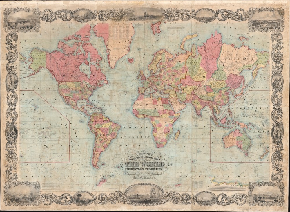
Colton's Illustrated and Embellished Steel Plate Map of The World on Mercator's Projection, Compiled from the latest and most Authentic Sources Exhibiting the recent Arctic and Antarctic Discoveries and Explorations.
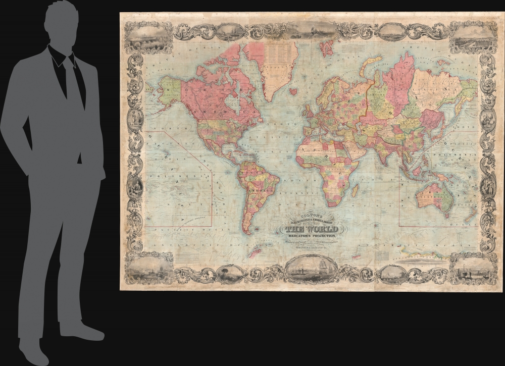
1856 (dated) 58 x 79.5 in (147.32 x 201.93 cm) 1 : 15000000
1856 (dated) 58 x 79.5 in (147.32 x 201.93 cm) 1 : 15000000
Description
This is D. Griffing Johnson and J. H. Colton's massive 1856 wall map of the world, considered 'one of the great American wall maps' (Rumsey). It is one of the largest and finest examples of American steel-plate engraving - a printing style that briefly surged in popularity under makers like Colton and Johnson, before being supplanted by lithography in the mid-19th century.
A Closer Look
The map is massive and as such offers significant detail nearly everywhere. At sea, countless explorer's routes are noted, from those of Columbus to the route of the U.S. Exploring Expedition (1838 - 1842), referenced obliquely in the title. The United States includes the slow partitioning of the Transmississippi, including the reconfiguration of the mid-west following the 1852 Kansas-Nebraska Act. Fillmore City is identified as the Capital of Utah Territory. There are several lengthy annotations relating to exploration, using the map, an explanation of scale, a nod to Gerard Mercator, and more. There is even an attempt to unwind the confusing quilt-work of mid 19th century German states - uncommon on a wall map.Dramatic Borders
The map is 'embellished' and 'illustrated' with an elaborate acanthus leaf surround with baroque elements and vignettes, including illustrations of cities and people. Clockwise from top left: London, New Orleans, The Landing of Columbus, St. Petersburg, Paris, a Swiss woman with Circassian and Greek soldiers, three people in Chinese Court regalia, the Hongs of Canton (Guangzhou), Rome, New York City, Naples (and Vesuvius), Constantinople (Istanbul), a Turkish harem scene, two South American Indians.Publication History and Census
This map is noteworthy as an exceptional example of steel-plate engraving - a printing method that rose to popularity in the mid-19th century. Steel plates were more durable than copper, and so allowed for larger print runs and had a much longer lifespan. This is moreover, one of just 2 or 3 maps that can be attributed to D. Griffing Johnson - all of which are magnificent. (D. Griffing should not be confused with A. J. Johnson, who was associated with Colton after 1858.) Griffing Johnson first issued the map in 1847 under his own name and imprint. The plates were sold to Colton in 1848, who reissued the copyright under his own name. Subsequent editions followed through 1868. The map in various editions is well represented in institutional collections, but very scarce to the market.CartographerS
Joseph Hutchins Colton (July 5, 1800 - July 29, 1893), often publishing as J. H. Colton, was an important American map and atlas publisher active from 1833 to 1897. Colton's firm arose from humble beginnings when he moved to New York in 1831 and befriended the established engraver, Samuel Stiles. He worked under Stiles as the 'Co.' in Stiles and Co. from 1833 to 1836. Colton quickly recognized an emerging market in railroad maps and immigrant guides. Not a cartographer or engraver himself, Colton's initial business practice mostly involved purchasing the copyrights of other cartographers, most notably David H. Burr, and reissuing them with updated engraving and border work. His first maps, produced in 1833, were based on earlier Burr maps and depicted New York State and New York City. Between 1833 and 1855, Colton proceeded to publish a large corpus of guidebooks and railroad maps, which proved popular. In the early 1850s, Colton brought his two sons, George Woolworth Colton (1827 - 1901) and Charles B. Colton (1832 - 1916), into the map business. G. W. Colton, trained as a cartographer and engraver, was particularly inspired by the idea of creating a large and detailed world atlas to compete with established European firms for the U.S. market. In 1855, G.W. Colton issued volume one of the impressive two-volume Colton's Atlas of the World. Volume two followed a year later. Possibly because of the expense of purchasing a two-volume atlas set, the sales of the Atlas of the World did not meet Colton's expectations, and so, in 1856, the firm also issued the atlas as a single volume. The maps contained in this superb work were all original engravings, and most bear an 1855 copyright. All of the maps were surrounded by an attractive spiral motif border that would become a hallmark of Colton's atlas maps well into the 1880s. In 1857, the slightly smaller Colton's General Atlas replaced the Atlas of the World. Most early editions of the General Atlas published from 1857 to 1859 do not have the trademark Colton spiral border, which was removed to allow the maps to fit into a smaller format volume. Their customers must have missed the border because it was reinstated in 1860 and remained in all subsequent publications of the atlas. There were also darker times ahead; in 1858, Colton was commissioned at a sum of 25,000 USD by the government of Bolivia to produce and deliver 10,000 copies of a large format map of that country. Although Colton completed the contract in good faith, delivering the maps at his own expense, he was never paid by Bolivia, which was at the time in the midst of a series of national revolutions. Colton would spend the remainder of his days fighting with the Bolivian and Peruvian governments over this payment, and in the end, after a congressional intervention, he received as much as 100,000 USD in compensation. Nonetheless, at the time, it was a disastrous blow. J. H. Colton and Company is listed as one of New York's failed companies in the postal record of 1859. This led Colton into the arms of Alvin Jewett Johnson and Ross C. Browning. The 1859 edition of Colton's General Atlas lists Johnson and Browning as the 'Successor's to J. H. Colton' suggesting an outright buyout, but given that both companies continued to publish separately, the reality is likely more complex. Whatever the case may have been, this arrangement gave Johnson and Browning access to many of Colton's map plates and gave birth to Johnson's New Illustrated (Steel Plate) Family Atlas. The Johnson's Atlas was published parallel to Colton's atlases well into the 1880s. The Colton firm itself subsequently published several other atlases including an Atlas of America, the Illustrated Cabinet Atlas, the Octavo Atlas of the Union, and Colton's Quarto Atlas of the World. They also published a large corpus of wall maps, pocket maps, and guides. The last known publications of the Colton firm date to 1897 and include a map and a view, both issued in association with the Merchant's Association of New York. Alice M. Colton married August R. Ohman (May 3, 1859 - April 22, 1934) on January 5, 1897. In 1898, Ohman joined the Colton firm, which continued to publish as Colton, Ohman & Co. until 1901. More by this mapmaker...
David Griffing Johnson (1808 - April 9, 1863), aka 'Griffin', is a mysterious but significant American engraver and mapmaker active in Portland, Maine, New Orleans, and New York City in the decades preceding the American Civil War (1861 - 1865). Our knowledge of him is scant. He was likely born in Connecticut. We believe him one and the same with David G. Johnson, a map engraver, who first appears in Portland, Maine in 1824, where he had an office at No. 4, Market Square in Gilbert’s Block. He was not a native to that city, instead arriving in 1824 with the intent to establish himself as the city's premier engraver. This seems not to have worked out, but he did produce a few maps, portraits, nautical charts, and novelties. He left Portland in 1830, eventually settling in New York, where we can place him in 1831. In New York he promoted himself as a portrait painter and engraver from 1831 to 1835. He appears to have had little success during this period, but did engrave the plates for the 1833 A Treatise on Topographical Anatomy. Shortly thereafter, he relocated to New Orleans. He was in New Orleans from at least 1838 to 1843, where he set up an engraving and daguerreotype studio. While there, he engraved E. H. Springbett and L. I. Pilié's 1839 Topographical Map of the City and Environs of New Orleans, of which we can frustratingly find no surviving examples but several references. We note correspondence in 1840 between Johnson and Samuel F. B. Morse (inventor of the telegraph and daguerreotype pioneer) asking for advice on daguerreotyping, suggesting that Johnson had difficulty with the process. He returned to New York in 1843, remaining until about 1847, when he issued a map with J. H. Colton. At some point, likely in 1848, D. Griffing Johnson headed west. His 1853 world map and his 1857 North America map both feature a large view of Sutter's Mill with the note, 'Drawn on the spot by D. G. Johnson in 1849'. It is thus believed he was at Sutter’s Mill when gold was discovered or shortly thereafter. There is record of a D. G. Johnson arriving in New York in 1849 on a ship from Jamaica - possibly a transit point having sailed around South America? He was in New York throughout the 1850s to about 1862 or 1863, producing several maps, including a large world wall map in 1853, a North America map in 1853 with 'Thayer, Bridgman and Fanning', and an 1854 North America map with A. J. Johnson, an 1860 world map with Jacob Monk, and an 1862 map of Maine with Henry Francis Walling and Jacob Chace Jr. In 1855 he had an office at 7 Nassau Street, New York. In 1859 he successfully defended himself in New York courts on charges of copyright violation by fellow mapmaker Robert Persall Smith. Regarding D. G. Johnson’s disappearance sometime after 1863, we can only speculate. If our reasoning stands, when was active in Maine in 1824 he would have been at least in his early 20s. Thus by 1863, he would have been in his late 60s, so it is likely he died, but records have been elusive. References: Groce, G.C,. and Wallace, D. H., The New-York Historical Society's Dictionary of Artists in America, 1864 - 1860, p. 353. Smith, M.G., and Tucker, M. L., Photography in New Orleans: The Early Year, 1840 - 1865, p 21-22. Palmquist, P. and Kailbourn, T. R., Pioneer Photographers from Mississippi to the Continental Divide, p. 357. Shettleworth, Earle G., 'Portland, Maine, Engravers of the 1820s', part II, 105 - 109, in Old-Time New England, Volume 61, Number 224 (Spring, 1971). Fales, Marthaq Gandy, 'An Unrecorded Portland Engraver', pages 77-79 in Old-Time New England, Volume 57, Number 207 (Winter, 1967). Learn More...
Condition
Very good. Full professional restoration. 6 sheets, joined, on linen.
References
Library of Congress, G3200 1854 .J6. Osher Map Library, OML-1855-61. Rumsey 4572.001. c.f. Rumsey 2156.001 (1847 D. Griffing Johnson edition).