
This item below is out of stock, but another example (left) is available. To view the available item, click "Details."
Details
1933 Keizo Shimada Japanese Manga Pictorial Map of the World
$1,500.00
1933 Keizo Shimada Japanese Manga Pictorial Map of the World
WorldPictorial2-keizo-1933$550.00

Title
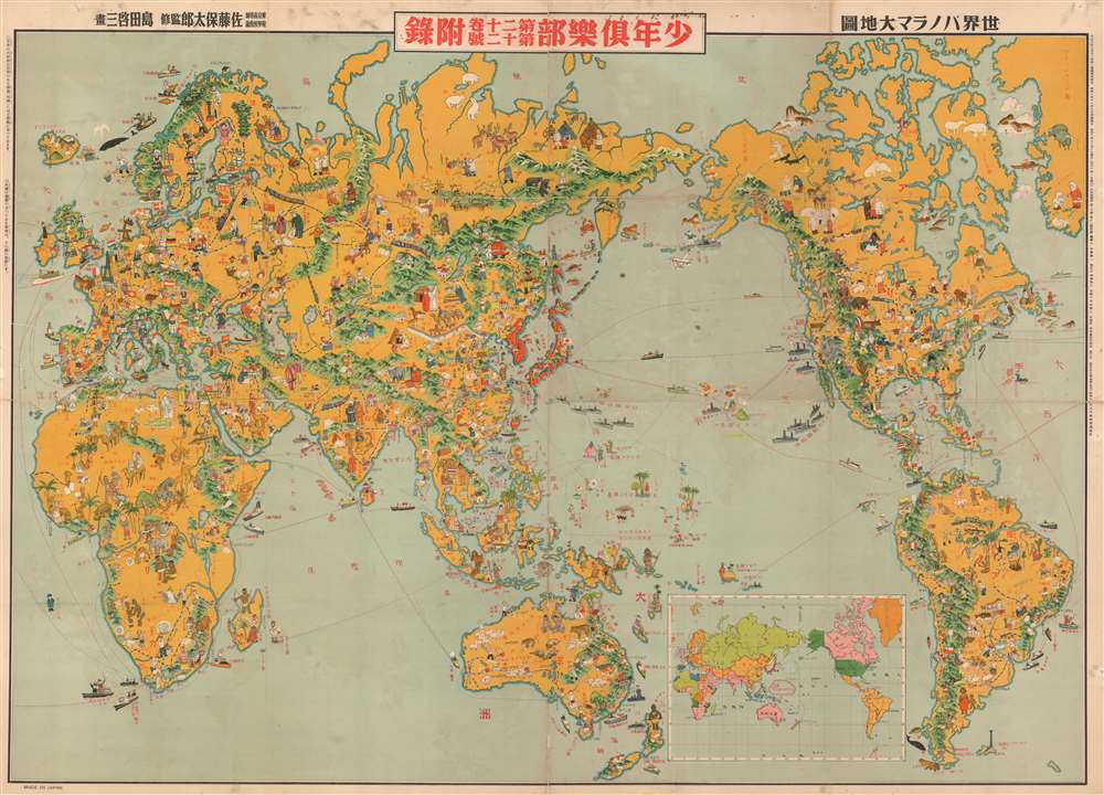
世界パノラマ大地圖 / World Panorama Daichi Sakai.
1933 (dated) 29.75 x 42 in (75.565 x 106.68 cm) 1: 38000000
1933 (dated) 29.75 x 42 in (75.565 x 106.68 cm) 1: 38000000
Description
A remarkable 1933 Japanese issue pictorial map of the world drawn by Keizo Shimada (島田啓三). Centered on the Japanese Empire, which is highlighted in Red and includes both Taiwan and Korea, this map extends to cover the world with the exception of the Atlantic, which is only minimally addressed. The map presents a delightful array of vignettes intended to illustrate regional culture, flora, and fauna. Some of the images, despite being unbearably 'kawaii' are decidedly not politically correct, such as the rather intimidating looking Indian Chief in the Rocky Mountains. Despite the map's playful nature, Japan had already begun its grab for power in East Asia and the military aspect of the map is clear. Japanese destroyers patrol the western Pacific just as American destroyers stand watch on the Pacific Coast and in Hawaii. War was coming.
Publication History and Census
This map is quite rare. It was published as a free insert in the December 1933 issue of Japan Youth Club or Shonen Club, a monthly boys' magazine that was issued by Yasutarō Satō (佐藤保太郎) from 1914 to 1946. We have been able to identify only one other example housed in the David Rumsey Collection.CartographerS
Keizo Shimada (島田 啓三; May 3, 1900 - 1973) was an early Japanese mangaka (漫画家), best known for his comic The Adventures of Dankichi, serialized in Youth Club (小年俱樂部) magazine, published by Dai Nippon Yūbenkai Kōdansha (大日本雄辯會講談社). The comic, based around the adventures of a young boy shipwrecked on a remote island in the South Pacific, was similar to The Adventures of Tintin. Like Tintin, it was later criticized for celebrating imperialism and denigrating other races. Dankichi also resembled its contemporary, another pioneering manga, Tagawa Suihō's Norakuro, in that both became a tool for propaganda during the Second Sino-Japanese War (World War II). More by this mapmaker...
Satō Yasutarō (佐藤裕太郎; March 5, 1893 – March 7, 1977), or Satō Yūtarō, was a Japanese educator active in Tokyo during the Taisho and Showa Eras. During and just prior to World War II, he worked with the Japanese Youth Club (少年俱樂部), a popular magazine which published several important manga maps of East Asia. After the war, Yasutarō became a professor at Tokyo University of Education and later, the the Senshu University. Learn More...
Condition
Good. Map laid down on archival tissue. Minor repairs on old fold lines.
References
Rumsey 10043.001. OCLC 1020976471.