This item has been sold, but you can get on the Waitlist to be notified if another example becomes available, or purchase a digital scan.
1561 Ruscelli / Ptolemy World Map
WorldPtolemy-ruscelli-1561-2$875.00

Title
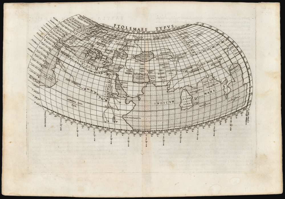
Ptolemaei Typus.
1561 (undated) 6.25 x 10 in (15.875 x 25.4 cm) 1 : 100000000
1561 (undated) 6.25 x 10 in (15.875 x 25.4 cm) 1 : 100000000
Description
This is Girolamo Ruscelli's 1561 plate of a foundational work of Renaissance cartography: the map of the known world as understood at the time of the Roman Empire. This presentation of ancient geography is refreshingly unique in that it employs Ptolemy's second projection, as opposed to the more typical, simpler first projection.
Perhaps Ptolemy's most fundamental innovation was to represent the three-dimensional world projected on a grid, providing the basis of all modern cartography. Ptolemy proposed two different methods of drawing such a projection. The first is the conic projection, based on a tangent to the Earth at the 36° parallel, with straight meridians that close towards the poles and parallels forming concentric arcs. The second projection was more complex: it modified the conic projection by presenting the meridians as curving inwards towards the poles. The latter was the model used for the present map.
With the exception of the 1482 Berlinghieri and the 1511 Sylvanus, all Ptolemaic world maps printed south of the Alps in the 15th and early 16th centuries were drawn using Ptolemy's first projection. Most of those printed north of the Alps followed the lead of Donnus Nicolaus Germanus in using Ptolemy's second projection. Since these were all woodcuts, however, most could not include the detail and clarity achieved on even a small copperplate engraving such as this. (Shirley calls it 'restrained and simple.')
The Ptolemaic 'world map' is thus a representation of only the known inhabited world, the Oikoumene. Its westernmost limit is the 'Fortunate Isles' (Fortunatae) in the Atlantic Ocean, and to the east, the projection ends at China (Sinarum Situs). The map shows from 63°N to 14°S, thus encompassing the British Isles as the northernmost limit of Europe, while the southern limits pass far beyond those areas familiar to 2nd-century travelers into the realm of speculation and legend.
Ptolemy's Projections
Apart from the 1482 Berlinghieri and the 1511 Sylvanus, this is the only Ptolemaic world map printed south of the Alps to do so. In terms of its composition and content, it has no identifiable precursor, and it was not imitated. It only appeared in the 1561-1564 editions of the Ruscelli Ptolemy; later editions of the work contained the simpler and more conventional first Ptolemaic projection. While many of the maps appearing in Ruscelli's Ptolemy were derived from Giacomo Gastaldi's 1548 edition, Gastaldi's Ptolemy contained no Ptolemaic world map.Perhaps Ptolemy's most fundamental innovation was to represent the three-dimensional world projected on a grid, providing the basis of all modern cartography. Ptolemy proposed two different methods of drawing such a projection. The first is the conic projection, based on a tangent to the Earth at the 36° parallel, with straight meridians that close towards the poles and parallels forming concentric arcs. The second projection was more complex: it modified the conic projection by presenting the meridians as curving inwards towards the poles. The latter was the model used for the present map.
With the exception of the 1482 Berlinghieri and the 1511 Sylvanus, all Ptolemaic world maps printed south of the Alps in the 15th and early 16th centuries were drawn using Ptolemy's first projection. Most of those printed north of the Alps followed the lead of Donnus Nicolaus Germanus in using Ptolemy's second projection. Since these were all woodcuts, however, most could not include the detail and clarity achieved on even a small copperplate engraving such as this. (Shirley calls it 'restrained and simple.')
A Closer Look
Employing Ptolemy's curvilinear projection, the present map labels Ptolemy's latitudes and longitudes at the top, bottom, and right-hand borders. Along the left border are more detailed labels of the climate zones, including the hours of daylight at the solstice at given latitudes. Ptolemy's data reflected that available to a 2nd-century Alexandrian, limited by that era's exploratory scope and its limited ability to measure distance accurately. The picture of the world thus presented is distorted despite the utility and importance of the methodology.The Ptolemaic 'world map' is thus a representation of only the known inhabited world, the Oikoumene. Its westernmost limit is the 'Fortunate Isles' (Fortunatae) in the Atlantic Ocean, and to the east, the projection ends at China (Sinarum Situs). The map shows from 63°N to 14°S, thus encompassing the British Isles as the northernmost limit of Europe, while the southern limits pass far beyond those areas familiar to 2nd-century travelers into the realm of speculation and legend.
The Indian Ocean and the Sinus Magnus
The Indian Ocean is presented as a massive inland sea. Note that at the southern limits of eastern Africa, the coastline turns sharply to the east and continues until it turns north, ultimately meeting the Asian coastline at China beyond the Malay Peninsula and 'India Beyond the Ganges.' The portion of the Indian Ocean enclosed beyond the peninsula, Ptolemy termed the Great Bay, or 'Magnus Sinus.' Portuguese journeys around Africa proved that the land connection between China and Africa around the Indian Ocean did not exist: what, then, was the extent of the Magnus Sinus? Did land reach around it to the south from China? Was the ocean discovered by Magellan the same body of water as this? Was the mysterious coastline at the eastern limit of Ptolemy's knowledge the same as the west coast of the Americas? All European geographical thinking about the Pacific Ocean and the nature of the American discoveries began from a foundation of knowledge encapsulated in this map.Africa and The Nile
Northern Africa was nearly as well understood by Ptolemy as was Europe itself: all fell within the bounds of the Roman Empire, and after all, the Greco-Roman Ptolemy was, himself, a native of Alexandria. Beyond the great African deserts, however, lay mysteries unknown. Ptolemy's sources told him of the sources of the Nile - found in the lakes of the Mountains of the Moon. This representation remained unchallenged on maps of Africa until the end of the 17th century.The Mysteries of Scythia and the East
The Indies and Africa were not the only lands draped in obscurity. Beyond the Black Sea to the north and east, Ptolemy's geography grows less and less detailed. The regions of Scythia, Serica, and the Imaum Mountains were - to Ptolemy's era - the domain of little-known nomadic peoples, often reputed to be cannibals. The Persian kingdoms of Sogdiana, Bactriana, Parthia, and so on are accurately placed, but the Caspian, or Hyrcanian, Sea is shown distorted into an east-west oval was not corrected in European geography until the 18th century.Publication History and Census
This map was first engraved, probably by Giulio Sanuto for the 1561 Valgrisi edition of Ruscelli's La Geographia di Claudio Tolomeo…, but it only remained in use until 1564. Editions 1574 and later contained a different map. The present example conforms typographically to the first Latin edition of 1562. The maps of this edition were engraved two-to-a-plate, and consequently, the platemark runs off the edge of the sheet at the top. (the same plate as Ruscelli's version of the Zeno map, Septentrionalium partium nova tabula.) We see eleven examples of the separate map listed in institutional collections. It appears on the market from time to time.CartographerS
Girolamo Ruscelli (1500 - 1566) was an Italian polymath, humanist, editor, and cartographer active in Venice during the early 16th century. Born in Viterbo, Ruscelli lived in Aquileia, Padua, Rome and Naples before relocating to Venice, where he spent much of his life. Cartographically, Ruscelli is best known for his important revision of Ptolemy's Geographia, which was published posthumously in 1574. Ruscelli, basing his work on Gastaldi's 1548 expansion of Ptolemy, added some 37 new "Ptolemaic" maps to his Italian translation of the Geographia. Ruscelli is also listed as the editor to such important works as Boccaccio's Decameron, Petrarch's verse, Ariosto's Orlando Furioso, and various other works. In addition to his well-known cartographic work many scholars associate Ruscelli with Alexius Pedemontanus, author of the popular De' Secreti del R. D. Alessio Piemontese. This well-known work, or "Book of Secrets" was a compilation of scientific and quasi-scientific medical recipes, household advice, and technical commentary on a range of topics that included metallurgy, alchemy, dyeing, perfume making. Ruscelli, as Alexius, founded a "Academy of Secrets," a group of noblemen and humanists dedicated to unearthing "forbidden" scientific knowledge. This was the first known experimental scientific society and was later imitated by a number of other groups throughout Europe, including the Accademia dei Secreti of Naples. More by this mapmaker...
Giulio Sanuto (fl. 1540 – 1580) was a Venetian engraver. He was born the illegitimate son of Cavaliere Francesco di Angelo Sanuto; With his brother, the cartographer and scientific instrument maker Livio Sanuto (1520 – 1576) he produced an array of some of the most important geographical works produced in Venice during the second half of the sixteenth century. These included a 27-inch globe and the 1588 12-sheet atlas, Geografia della Africa. Giulio's career is singluar among Venice's engraves in that it appears to have been equally based on artistic, figurative work as well as his cartographic works. Giulio is more broadly known for a small but sought-after selection of decorative engravings; no more than twelve of these can be attributed confidently to him, including the monumental Apollo and Marsyas, measuring over 1.30 meters wide. Whilst Sanuto's engravings were generally based upon the designs of other artists, his work was both ambitious and grand, and he often signed these works. Learn More...
Source
Ruscelli, G., La Geografia di Claudio Tolomeo Alessandrino…, (Venice: Vincenzo Valgrisi) 1562.
Beginning in 1561, Girolamo Ruscelli published this important, expanded edition of Giacomo Gastaldi's 1548 Ptolemy. Its maps, engraved in Venice by Giulio Sanuto, were in the main based directly upon those in Gastaldi's 1548 work. The maps were larger format than Gastaldi's, however, and Sanuto's engraving was far clearer and more legible than those appearing in the 1548 work. There are some important additions that distinguish Ruscell's Ptolemy from Gastaldi's. Ruscelli's work contained a map of the habitable world according to Ptolemy, which the Gastaldi lacked; also, the double-hemisphere map appearing in the Ruscelli was new and did not appear in the Gastaldi. Ruscelli's modern map of England was based on the work of George Lily, rather than the Waldseemüller-derived map appearing in the Gastaldi; the Ruscelli is the earliest generally acquirable map of England based on knowledge from someone who lived there. In a fateful innovation, Ruscelli's work included Septentrionalium partium nova tabula,the first copy of Nicolo Zeno's 1558 fraud Carta da Navegar, which introduced a novel mapping of the north parts of the world, including the phantom islands of Frisland, Icaria, Drogeo and Estotiland. Had Ruscelli not copied the Zeno - which had a narrow, brief publication - this preposterous geography would have probably not taken hold. Its inclusion in Ruscelli's beautiful, authoritative and popular work would lead to the adoption of the Zeno map by Mercator, Ortelius, Plancius and their successors, baffling scholars for centuries. Ruscelli's Ptolemy had a long publication history, cementing the influence of the work. It appeared both in Italian and Latin editions, all printed in Venice, throughout the latter 16th century:
- 1561 La Geographia di Claudio Tolomeo Alessandrino, Italian. Venice, Vincenzo Valgrisi.
- 1562 Geographia Cl. Ptolemaei Alexandrini, Latin. Venice, Vincenzo Valgrisi.
- 1564 La Geographia di Claudio Tolomeo Alessandrino, Italian. Venice, Giordano Ziletti.
- 1564 Geographia Cl. Ptolemaei Alexandrini, Latin. Venice, Giordano Ziletti.
- 1574 La Geographia di Claudio Tolomeo Alessandrino, Italian. Venice, Giordano Ziletti.
- 1598 Geographia di Claudio Tolomeo Alessandrino, Italian. Venice, heirs of Melchoir Sessa.
- 1599 Geographia di Claudio Tolomeo Alessandrino, Italian. Venice, heirs of Melchoir Sessa.
Condition
Excellent. Few minuscule, invisibly filled wormholes.
References
Rumsey 11311.008. OCLC 68568894. Shirley, Rodney W., The Mapping of the World: Early Printed World Maps 1472-1700, #109.