
1957 McCormick Pictorial World Spice Map, w/ Routes of Explorers



This item has been sold.
McCormick's Map of the World.
Search for Tastier Food.
Choose a Collection:
This Item
Enquire
Search for Tastier Food.
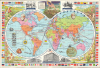
This is a 1957 pictorial map of the world printed by the spice company McCormick (McCormick-Schilling). Colorful and informative, the map illustrates the world of spices through the historical spice trade and early modern cartography.A Closer Look
The map covers the world on a double-hemisphere projection. A wealth of information is offered, ranging from the locations where various spices in the McCormick portfolio are sourced to the routes of important explorers and purely decorative elements. Surrounding the map are illustrations of spice harvesting, patriotic imagery (including Fort McHenry, alluding to the company's Baltimore roots), and promotional depictions of McCormick-Schilling offices. The map is further surrounded by flag illustrations from various spice-producing countries around the world and by portraits of great overland and seafaring explorers. The inclusion of anthropomorphic wind heads, a zodiac chart, and mythical sea creatures harken, like the double-hemisphere projection, to the world maps of the early modern period. Indeed, much of early exploration was motivated by the unquenchable market for flavor. The verso includes an 'Encyclopedia of flavoring extracts - spices - teas - coffees,' drawings of McCormick products, and colorful illustrations of trading ships.Publication History and Census
This map was printed by A. Hoen for McCormick in 1957. McCormick issued numerous 'spice maps' in various sizes and formats from the 1920s to the early 1970s, with this being the largest and most decorative. This particular iteration was published from 1955 onwards with minor adjustments to each subsequent edition. The present edition is noted in the OCLC among the holdings of the Osher Map Library at the University of Southern Maine.Condition
Very good. Light wear along original fold lines. Verso repairs to fold separations and at fold intersections. Slight loss at a few fold intersections.
References
Rumsey 8849.003. OCLC 5449991.