1862 Arrowsmith Map of the Yangtze River, China
YangTszeKiang-arrowsmith-1862$125.00

Title
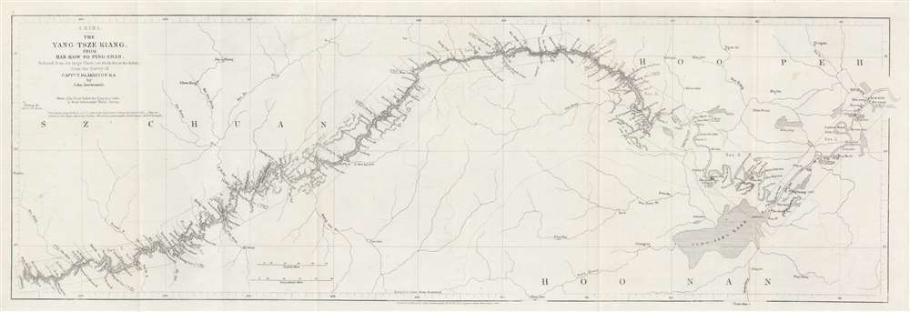
China. The Yang-Tsze Kiang, from Han-Kow to Ping-Shan; reduced from the large Chart (of which this is the Index) from the Survey of Captain T. Blakiston R.A.
1862 (dated) 7.75 x 23.25 in (19.685 x 59.055 cm) 1 : 1837440
1862 (dated) 7.75 x 23.25 in (19.685 x 59.055 cm) 1 : 1837440
Description
This is an 1862 John Arrowsmith map of the Yangtze River, China. Coverage extends from Hankou (Hankow) to Pingshan. The map follows 1861 Thomas Wright Blakiston (December 27, 1832 - October 15, 1891) Yangtze River Expedition. Blakiston's expedition traveled over 900 miles further up the river than any previous Western navigation. Blakiston also conducted detailed surveys of the Yangtze and produced a landmark map of the river. The present map acts as a key for Blakiston's larger map. Cities and towns of varying size are labeled throughout. Additional notations mark the now submerged Yangtze Gorges and other physical features.
Publication History and Census
This map was created by John Arrowsmith and published in the 1862 edition of The Journal of the Royal Geographical Society. An example is cataloged in OCLC and is part of the institutional collection at the National Library of Scotland.CartographerS
Aaron Arrowsmith (1750-1823), John Arrowsmith (1790-1873), and Samuel Arrowsmith. The Arrowsmith family were noted map engravers, publishers, geographers, and cartographers active in the late 18th and early 19th century. The Arrowsmith firm was founded by Aaron Arrowsmith, who was trained in surveying and engraving under John Cary and William Faden. Arrowsmith founded the Arrowsmith firm as a side business while employed by Cary. The firm specialized in large format individual issue maps containing the most up to date and sophisticated information available. Arrowsmith's work drew the attention of the Prince of Wales who, in 1810, named him Hydrographer to the Prince of Wales, and subsequently, in 1820, Hydrographer to the King. Aaron Arrowsmith was succeeded by two sons, Aaron and Samuel, who followed him in the map publication business. The Arrowsmith firm eventually fell to John Arrowsmith (1790-1873), nephew of the elder Aaron. John was a founding member of the Royal Geographical Society. The firm is best known for their phenomenal large format mappings of North America. Mount Arrowsmith, situated east of Port Alberni on Vancouver Island, British Columbia, is named for Aaron Arrowsmith and his nephew John Arrowsmith. More by this mapmaker...
Royal Geographical Society (fl. 1830 - present) is a British Society established in 1830 to promote geographical science and exploration. Originally titled the "Geographical Society of London", the RGS received its royal charter from Queen Victoria in 1859 shortly after absorbing several similar but more regional societies including the African Association, the Raleigh Club and the Palestine Association. The RGS sponsored many of the most important and exciting voyages of exploration ever undertaken, including the exploration of Charles Darwin, David Livingstone, Robert Falcon Scott, Richard F. Burton, John Speke, George Hayward, H. M Stanley, Ernest Shackleton and Sir Edmond Hillary. Today, the RGS remains a leading global sponsor of geographical and scientific studies. The Society is based in Lowther Lodge, South Kensington, London. Learn More...
Source
Sarel, H.A., 'Notes on the Yang-tsze-Kiang, from Han-kow to Ping-shan', The Journal of the Royal Geographical Society Vol. 32 (London: John Murray) 1862.
Condition
Very good. Exhibits light wear along original fold lines.
References
OCLC 316517087.