This item has been sold, but you can get on the Waitlist to be notified if another example becomes available, or purchase a digital scan.
1823 Franklin Map of Manitoba and Saskatchewan, Canada
YorkFactoryCumberland-franklin-1823$375.00

Title
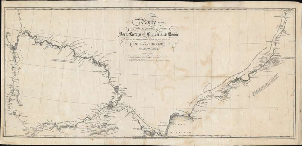
Route of the Expedition from York County to Cumberland House and the Summer and Winter Tracks from thence to Isle a la Crosse in 1819 and 1820.
1823 (dated) 10.5 x 22 in (26.67 x 55.88 cm) 1 : 1800000
1823 (dated) 10.5 x 22 in (26.67 x 55.88 cm) 1 : 1800000
Description
This is an 1823 John Franklin map of Manitoba and Saskatchewan, Canada. Depicting from York Factory, Manitoba, to Lac Île-à-la-Crosse in Saskatchewan, the map traces the first two years of Franklin's ill-fated Coppermine Expedition. Franklin marks the expedition's daily camps, beginning on September 9, 1819, in York Factory. Short notes provide information concerning the soil, trees, and other flora. Locations of latitude measurements are even noted. Numerous lakes are identified, including Lake Winnipeg. Portages (when the river was impassable by boat) also appear along the expedition's route and the distance of each is provided in yards.
The Coppermine Expedition
The Coppermine Expedition, led by this map's creator, John Franklin, was organized by the Royal Navy and had a stated goal of mapping the Canadian coastline from the mouth of the Coppermine River eastward to the Hudson Bay. Poor planning and bad luck plagued the expedition from the start. Few supplies were sent with the expedition from England because planners chose to rely on the Hudson's Bay Company and the North West Company. These two had recently fought a de facto war over trapping rights and did not operate well - to say the least. Thus, even on the expedition's arrival in Canada, the needed supplies did not appear as expected, and the provided boats were too small for what little they had. Nonetheless, the expedition set out from York Factory, believing that the necessary provisions would be sent. For the next two years, as the men labored up rivers and suffered through harsh Canadian winters, their supply woes never ended. Franklin, though, never chose to turn back, and he and his men set off down the Coppermine River in June 1821 as planned, but their progress was slower than imagined. By late August, with only 500 miles mapped, the group elected to return toward their winter 1820 camp. Their rations ran out by the first week of September, and game, which had been scarce the entire journey, proved elusive. In the end, only eleven of the twenty-two men who left York Factory survived, and the expedition was marred by accusations of murder and cannibalism.Publication History and Census
This map was created by John Franklin, engraved by John Walker, and published by John Murray II in John Franklin's book, Narrative of a Journey to the shores of the Polar Sea, in the years 1819, 20, 21, and 22. Four examples of the separate map are cataloged in OCLC. They are part of the institutional collections at the University of Montana, Washington State University, Stanford University, and the Bavarian State Library. An example is also part of the collection at the John Carter Brown Library.CartographerS
Sir John Franklin (April 16, 1786 - June 11, 1847) was a British Arctic explorer and an officer in the Royal Navy. Born in Spilsby, Lincolnshire, Franklin was the ninth of twelve children. Educated at a grammar school in Louth, Franklin soo developed an interest in a career at sea, although his father wanted him to either become a businessman or enter the clergy. Somehow, Franklin convinced his father to let him embark on a trial voyage aboard a merchant ship at the age of twelve, which only confirmed his wishes. So, his father secured him a Royal Navy appointment aboard the HMS Polyphemus in March 1800. Franklin joined the Polyphemus in the fall of 1800, and was aboard during the Battle of Copenhagen in the following year, when the Polyphemus was part of Horatio Nelson's squadron. Franklin was then transferred to the HMS Investigator, and embarked on an expedition to Australia as a midshipman. He fought in several other battles during the Napoleonic Wars, and was even present at the Battle of Trafalgar in 1805 aboard the HMS Bellerophon. He was wounded at the Battle of Lake Borgne during the War of 1812. Franklin's first command was the HMS Trent in 1818. Franklin led the ill-fated Coppermine Expedition between 1819 and 1822, which saw the death of 11 of the 22 members of the team. Franklin returned to England in 1823 and married Eleanor Anne Porden, and the couple had a daughter the following year, also named Eleanor. His wife Eleanor died of tuberculosis in 1825. He led the Canadian Mackenzie River expedition in 1825, which was much more successful than the disastrous Coppermine expedition. He remarried on November 5, 1828, to Jane Griffin. Franklin then served as Lieutenant Governor of Van Diemen's Land (Tasmania) from 1837 until he was removed from office in 1843. After leaving Van Diemen's Land, Franklin was named commander of yet another Arctic expedition, his fourth. This expedition, meant to complete the charting of the Northwest Passage, is now known as Franklin's lost expedition, because Franklin and all the men on his team either died or disappeared. More by this mapmaker...
John Walker (1787 - April 19, 1873) was a British map seller, engraver, lithographer, hydrographer, geographer, draughtsman, and publisher active in London during the 19th century. Walker published both nautical charts and geographical maps. His nautical work is particularly distinguished as he was an official hydrographer for the British East India Company, a position, incidentally, also held by his father of the same name. Walker's maps, mostly published after 1827, were primarily produced with his brothers Charles Walker and Alexander Walker under the imprint J. and C. Walker. Among their joint projects are more than 200 maps for the influential Society for the Diffusion of Useful Knowledge Atlas (SDUK). In addition they published numerous charts for James Horsburgh and the British Admiralty Hydrographic Office, including Belcher's important map of Hong Kong and Carless' exploratory map of Karachi. The J. and C. Walker firm continued to publish after both Walkers died in the 1870s. Learn More...
John Murray I (1737 - 1793) founded the British publishing firm John Murray (1768 - present) in London. Born in Edinburgh, Murray served as an officer in the Royal Marines and built a list of authors that included Isaac D’Israeli and published the English Review. Murray the elder also was one of the founding sponsors of the London evening newspaper The Star in 1788. John Murray II (November 27 1778 - June 27, 1843) continued the family publishing business and developed it into one of the most important and influential publishing houses in Britain. The list of authors published by the firm grew to include Jane Austen, Sir Walter Scott, Washington Irving, George Crabbe, and Lord Byron under his tenure. Murray II also moved the business to 50 Albermarle Street in Mayfair, which became famous for Murray’s tradition of ‘four o’clock friends’, which was afternoon tea with his writers. John Murray III (1808 - 1892) continued to grow the business, and the firm published the first English translation of Goethe’s Theory of Colours, David Livingstone’s Missionary Travels and Charles Darwin’s Origin of Species during his tenure. Murray also published Herman Melville’s first two books. The firm began publishing Murray Handbooks in 1836, an ancestor of all modern travel guides. Sir John Murray IV (1851 - 1928) was publisher to Queen Victoria. Three successive Murray’s after Murray IV led the business until it was purchased by Hodder Headline in 2002, which was acquired by the French conglomerate Lagardère Group in 2004. Today, Murray is an imprint of Lagardère under the imprint Hachette UK. Learn More...
Source
Walker, J., Narrative of a Journey to the shores of the Polar Sea, in the years 1819, 20, 21, and 22 (London: John Murray) 1823.
Condition
Good. Even overall toning. Exhibits some offsetting. Some old creases.
References
OCLC 1076363862.