
64th Engineer Base Topographic Battalion (sold)

64th Engineer Base Topographic Battalion (fl. c. 1941 - 1971) was the primary cartographic arm of the U.S. Army in Asia during World War II (1939 - 1945) and the Korean War. Beginning in the Pacific during the First World War, 64th Engineer Topo pioneered modern aerial mapping, producing thousands of maps of little-known and previously unmapped islands - among them Iwo Jima. They also leveraged existing cartography to update and reproduce relevant historical maps. Their efforts were instrumental in the American recapture of the Philippines, the occupation of Japan, and throughout the Korean War. Operations spanned across multiple countries, including Libya, Iran, Ethiopia, and Liberia, showcasing their adaptability and the crucial nature of their work in challenging environments. The unit was disbanded in the early 1970s when satellite mapping made their work obsolete.
Hong Kong during World War II.
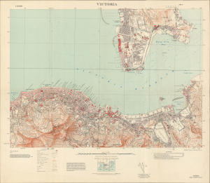
Victoria.
sold
- Digital Map Information
- Suitable for large format printing
- File Size: 919.49 MB
- File Type: ZIP / TIFF
- ICC color profile embedded
- Delivered instantly via download link
An exceptional 1945 detail map of Victoria Harbor and City, Hong Kong, issued by the U.S. Army's 64th Engineer Base Topographic Battalion near the end of World War II, when Hong Kong was still suffering under the Japanese Occupation. (more details)