
Broenner, Henry Lodowick (sold)

Henry (Harry) Lodowick (Louis) Broenner (Brönner) (December 21, 1702 - May 25, 1769) was a German book and printseller established in Frankfurt am Main. Virtually nothing is known of his youth or history, outside of his published works. In 1752 he published an edition of Crespel's popular account of his voyages in Canada; in 1777 he published an edition of Marmontel's account of the destruction by the Spanish of the Peruvian Empire. He produced a large number of maps pertaining to the European theatre of the Seven Years' War, most of which focused on the campaigns participated in by the mercenary forces of Hesse-Cassel (after all, Frankfurt is in Hesse.) These were predominantly not original publications - his source for most were the works of the French cartographer Beaurain. But what his maps lacked in originality they had in topicality and timeliness. He produced no atlas, and it is probable that his maps were separate issues intended for sale at the Frankfort messe, the international fair which descended upon Frankfort-am-Main twice a year. Such maps were a popular seller, being crucial in the spread of news of current political affairs: an important aspect of the messe.
After his death in 1769, his sons Heinrich Remigius Brönner (d.1798) and Johann Carl Brönner (d. 1812) continued to operate the business, Brönnersche Buchhandlung und Druckerei, apparently continuing to use their father's imprint. It is almost certainly in the same vein of their father's newsworthy maps that the younger Brönners produced their 1777 copy of the Holland/ Pownall map of New York and New Jersey: not just the timeliness of the news, but its relevance to German and particularly to Hessian interests. (The British were employing a large number of Hessian mercenaries in the conflict.)
After his death in 1769, his sons Heinrich Remigius Brönner (d.1798) and Johann Carl Brönner (d. 1812) continued to operate the business, Brönnersche Buchhandlung und Druckerei, apparently continuing to use their father's imprint. It is almost certainly in the same vein of their father's newsworthy maps that the younger Brönners produced their 1777 copy of the Holland/ Pownall map of New York and New Jersey: not just the timeliness of the news, but its relevance to German and particularly to Hessian interests. (The British were employing a large number of Hessian mercenaries in the conflict.)
Revolutionary War Map for the Hessian Market.
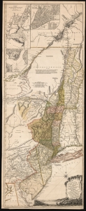
The Provinces of NEW YORK, and NEW JERSEY; with part of PENSILVANIA, and the Province of Quebec. Drawn by Major Holland, Surveyor General, of the Northern District in America. Corrected and Improved, from the Original Materials, By Governr. Pownall, Member of Parliament. Published by Harry Lodowick Broenner, Book-seller to Franckfort upon the Mayn. 1777.
sold
- Digital Map Information
- Suitable for large format printing
- DPI: 600
- File Size: 162.27 MB
- File Type: ZIP / TIFF
- ICC color profile embedded
- Delivered instantly via download link
This is a rare, separately issued German edition of the best-informed map available focusing on the northern theatre of the American Revolution: Samuel Holland's 1775 map of The Provinces of New York and New Jersey, in its final version corrected by Governor Thomas Pownall. This map was published by the heirs of Harry Lodowick Broenner, a Frankfurt-am-Main bookseller, whose forays into cartography were characterized by the swift reproduction of up-to-date maps, topically relevant to Frankfurter interests. As the Holland-Pownall map provided the best available view of the American war zone in which Hessian mercenaries were expected to be active, it would have been an apt target for the Broenners. (more details)