
Arkstée, Johann Caspar (sold) (Hans Kaspar Arkstée, Hans Kasper Arkstée, Jean Caspar Arkstée)

Johann Caspar Arkstée (c. 1700 - 1776) was a Dutch bookseller, printer, and publisher of geographical works active in Amsterdam and Leipzig during the 18th century. Also known as Hans Kaspar or Hans Kasper Arkstée, he grew up in Nijmegen, where his father settled with him in 1703, and reportedly left the city at nineteen. In 1734, he established the publishing partnership Arkstée and Merkus with his half-brother Hendrik Merkus (1714/15 - 1774). The partners established themselves in Leipzig during the later 1730s and were formally established in Amsterdam by 1740, operating there on the Oude Turfmarkt. Their contribution to cartography lay principally in publishing maps within geographical, historical, and travel literature. Among their substantial undertakings was the map-illustrated Allgemeine Historie der Reisen zu Wasser und zu Lande, published in Leipzig in 1747 - 1774. They also issued the Journal du siège de Berg op Zoom en 1747 in 1750, with an accompanying map. The firm maintained its own printing establishment and participated in the international book trade, including the Frankfurt book fair in 1737 - 1765. Arkstée was also an author: his Nijmegen, de oude hoofdstad der Batavieren, first published in 1733, combined a verse description of the city with historical and antiquarian annotations. Following Merkus's death in 1774 and Arkstée's death in Amsterdam in 1776, Merkus's widow, Elselina Vaster, continued the Amsterdam business on a reduced scale.
AKA: Hans Kaspar Arkstée, Hans Kasper Arkstée, Jean Caspar Arkstée
State-of-the-art mapping of Lake Champlain at the outbreak of the French and Indian War.
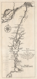
Karte von dem Fluße Richeliue und dem See Champlain Nach den Manuscripten des Schatzes von Karten Grüdrißen und Tagebüchern der Marine.
sold
- Digital Map Information
- Suitable for large format printing
- File Size: 3.14 MB
- File Type: ZIP / TIFF
- ICC color profile embedded
- Delivered instantly via download link
This is the 1756 German edition of the 1744 Bellin map of Lake Champlain and the St. Lawrence River. Bellin composed this map from French surveys conducted in the 1740s, making it one of the earliest accurate maps of Lake Champlain. This map was the state-of-the-art of Lake Champlain cartography and was the best available map of Lake Champlain at the outbreak of the French and Indian War (1754 - 1763) and the American Revolutionary War (1775 - 1783). Bellin's work was only supplanted when the British published Brassier's map in 1776. (more details)