
Barker, Elihu (sold)

Elihu Barker (17?? - 1792) was an English-American adventurer, engraver, and mapmaker active in Kentucky in the late 18th century. Little is known of Barker's life. Scholarship suggests he was born in England. He appears in Philadelphia as 'An Engraver for M. Carey' in the 1790s. His is best known for 'surveying' and producing the first serious large-scale map of Kentucky - a remarkable achievement for the time. Barker, must have moved to Kentucky in the 1770s or early in the 1780s to work on this map. He died in Philadelphia in 1782, a year before his great map was published. Promotion of the map was taken over by his son, Oliver Barker, a resident of Kentucky. Another of Barker's sons, William Barker (June 29, 1770 - April 19, 1805, engraved the map and followed in his father's footsteps, becoming an engraver for the Carey firm.
One of the earliest obtainable maps of Kentucky.
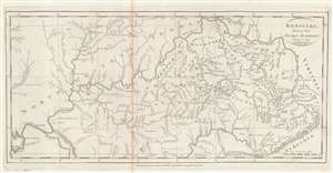
Kentucky, Reduced from Elihu Barker's Large Map.
sold
- Digital Map Information
- Suitable for large format printing
- Full resolution TIFF file
- ICC color profile embedded
- Delivered instantly via download link
An example of Matthew Carey's 1795 reduction of Elihu Barker's map of Kentucky - one of the earliest obtainable specific maps of Kentucky based upon actual observation and settlement. It also follows closely on Kentucky's admission to the Union. The map is a reduced version of the unobtainable Elihu Barker map of 1793, entitled A Map of Kentucky from Actual Survey, by Elihu Barker, also published by Carey in Philadelphia. The present map has less detail, given the reduced size, but closely adheres to Barker's important map, described as 'so well done it cold be used today with satisfaction'. Throughout, settlements, stations, salt licks, courthouses, furnaces, springs, planned settlements, and forts are noted - providing an invaluable insight into life in Kentucky when it was still the 'frontier'. (more details)