
Bernard, Jean-Frédéric (sold)

Jean-Frédéric Bernard (1683 - June 27, 1744) was a French Huguenot bookseller, historian, theologist, and publisher active in Amsterdam in the first half of the 18th century. Bernard was likely from Velaux, Provence, France. In 1685, the Bernard family was expelled from France as heretics due to religious law put into place under Louis IV. The family relocated to Amsterdam, where his father became a pastor. Jean-Frédéric briefly moved to Geneva, where he established himself as bookseller, but by 1705, was back in Amsterdam with a new bookshop. His most significant work is the multi-volume Recueil de voyages au Nord, published between 1715 and 1738, significant for marking the beginning of scientific criticism in matters of geographical facts. His theological writings bordered on heretical, one of his declarations being that 'in general all religions were similar, for they had the same principles and pursued the same objectives'. Nonetheless, he was a smart businessman and highly successful. Amsterdam tax records from 1742 placed him near the top of the Dutch publishing hierarchy. After his 1844 death, his Swiss son-in-law, Marc Michel Rey (1720 - 1780) took over the bookselling and publishing business.
Hennepin ... reconsidered?
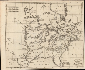
Le Cours de Fleuve Missisipi, Selon les Relations les plus modernes.
sold
- Digital Map Information
- Suitable for large format printing
- DPI: 600
- File Size: 33.38 MB
- File Type: ZIP / TIFF
- ICC color profile embedded
- Delivered instantly via download link
This is an interesting 1737 Dutch issue of Louis Hennepin's map of 1697, prepared by J. F. Bernard. It is based on the second of Hennepin's three maps, considered the map most influential in perpetrating Hennepin's fraud regarding the course of the Mississippi. The mapping of the Mississippi here, which meets the Gulf of Mexico far west of its actual location, was instrumental in fostering nearly 50 years of cartographic misrepresentation. (more details)