
Blondeau, Alexandre (sold)

Alexandre Blondeau (fl. c. 1799 - 1828) was a French line engraver based in Paris. In 1816 during the reign of Louis XVIII, he was appointed 'Graveur du Roi' and 'Premier Graveur du Dépot de la Guerre'. His apprentices include the topographical engraver Pierre Léonard Dandeleux (1783 - 1850).
Louisiana on the cusp of the Louisiana Purchase.
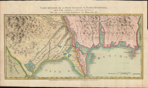
Carte Détaillée de la Basse-Louisiane et Floride Occidentale, pour étre adaptée à l'Ouvrage intitulé, Vue da la Colonie Espagnol due Mississipi, et c.
sold
- Digital Map Information
- Suitable for large format printing
- DPI: 600
- File Size: 21.22 MB
- File Type: ZIP / TIFF
- ICC color profile embedded
- Delivered instantly via download link
This is Alexandre's Blondeau's exceptional 1803 map of Spanish-administered Louisiana and West Florida, issued for Pierre-Louis Berquin Duvallon's travel narrative, Vue de la Colonie Espagnole due Mississipi. It is one of the best maps to capture the Gulf littoral during the Post-American Revolutionary War Spanish period on the cusp of the Louisiana Purchase. (more details)
Louisiana on the cusp of the Louisiana Purchase.
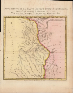
Carte Reduite de la Haute-Louisiane et Pays Circonvoisins, pour etre adaptee a l'ouvrage intitule Vue de la Colonie Espagnole du Mississipi, et c.
sold
- Digital Map Information
- Suitable for large format printing
- DPI: 300
- File Size: 3.12 MB
- File Type: ZIP / TIFF
- ICC color profile embedded
- Delivered instantly via download link
This is Alexandre's Blondeau's exceptional 1803 map of Spanish-administered upper Louisiana, issued for Pierre-Louis Berquin Duvallon's travel narrative, Vue de la Colonie Espagnole due Mississipi. It is one of the best maps to capture the Upper Mississippi Valley on the cusp of the Louisiana Purchase. The map moreover underscores the significance of the Mississippi River as a trade artery between the Great Lakes, and hence the Atlantic, and the Gulf of Mexico. (more details)